La Nina is upon us, increasing the likelihood of above normal rainfall and cloud this summer across much of Australia, especially for the northern and eastern coastline.
La Nina explained simply.
La Nina is well underway in the central and eastern equatorial Pacific waters, with significant cooling observed during the last few months. The atmospheric and ocean conditions have both exceeded La Niña thresholds, increasing the confidence of La Niña influencing the outlook at least until the end of summer.
It is well known that La Nina brings wet conditions to Australia, but it also increases the number of cyclones and brings an early start to the northern wet season. During La Niña years, there is a greater risk of flooding compared to other years across northern and eastern Australia, due to high moisture levels in the atmosphere.
How much solar influx is likely this summer with La Nina upon us?
Normal to below normal solar influx is likely this summer owing to increased number of days with cloud and rain. This is particularly true for the eastern coastline and rooftop solar in Sydney and Brisbane, due to the cities proximity to the Pacific Ocean and onshore flow. Northern Australia can expect frequent shower and storm activity within the monsoon trough this summer, bringing more cloudy days than normal.
On Saturday the 24th of October the eastern NEM (National Electricity Market) observed a very low solar radiation day due to thick clouds over eastern Australia (Figure 1). Increased periods of cloud cover is typical of a La Niña event and highlights the need for accurate and timely forecasts for effective solar operations.
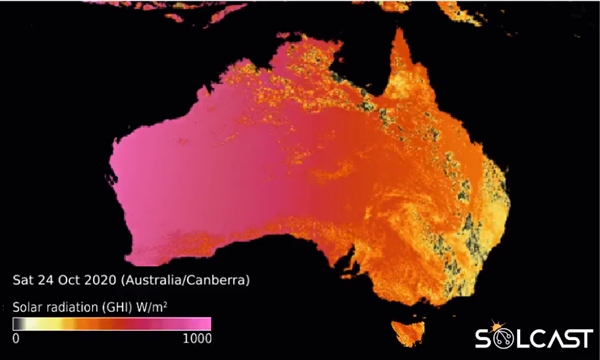
Figure 1: Solcast’s solar radiation forecast for Saturday the 24th of October 2020.
How will Australia’s solar influx change with our warming climate?
Australia’s climate is changing, with studies showing a higher frequency of El Nino (drier conditions/possible drought) events after the 1970’s. A continued decrease in winter rainfall across southern and eastern Australia is expected in the future, likely leading to periods of drought. Solar farms located in southeastern Australia are probable to observe more sunny days in the future overall. However, short and heavy rainfall events are expected to increase due to climate change.
Northern Australia’s rainfall has increased in recent years, which is expected to continue under the influence of climate change. Therefore, an increased number of cloudy days across northern Australia are estimated in the future, which may inhibit solar influx.
Another impact of climate change is a greater proportion of high intensity storms and fire seasons, emphasising the importance of risk mitigation for solar farms and other infrastructure.
For more information about Weatherzone’s solar services, please contact us at apac.sales@dtn.com.


