The downstream influence of Severe Tropical Cyclone Fina caused intense inland heat to build and be drawn into eastern Australia, causing energy demand to soar in NSW and Queensland.
Severe Tropical Cyclone Fina crossed the northeast Kimberley coast in WA late on Monday, November 24, 2025, but downstream influences from the system will be felt 3,000 km away as vast amounts of heat from the Timor Sea is drawn and transported into higher levels of the atmosphere.
Image: Severe Tropical Cyclone Fina approaching the northeast Kimberley coast on Monday, November 24, 2025.
This warm upper-level air moved southwards before descending over the Australian continent under the influence of an upper-level high pressure system.
One important point to note about the air that Fina ejected into the upper-atmosphere is that while it has lost a lot of the moisture it began with, it has retained its potential temperature. This means the air warmed up significantly as it descends towards the ground over central Australia over the weekend and early week, a process called adiabatic warming.
The two maps below show the maximum temperature forecasts for Wednesday and Thursday, respectively, highlighting heat pushing into NSW and then Queensland in the coming days.
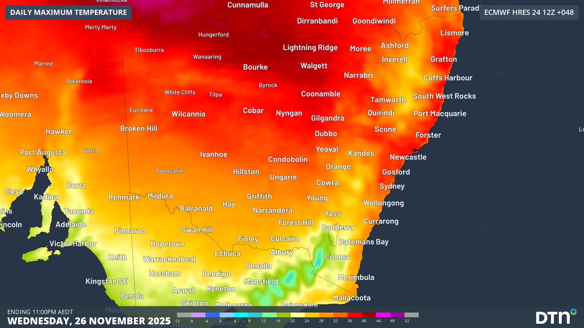
Image: Forecast maximum temperatures across NSW on Wednesday, November 26, 2025.
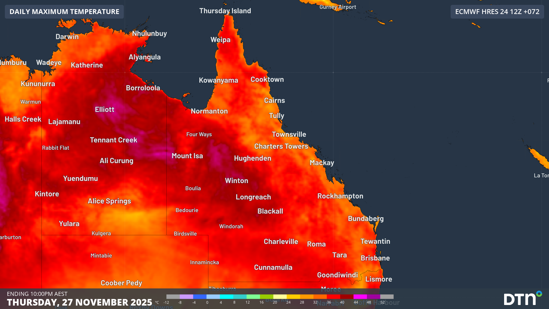
Image: Forecast maximum temperatures across Queensland on Thursday, November 27, 2025.
Temperatures are forecast to reach 36°C on Wednesday for Sydney, and 36°C on Thursday for Brisbane, driving high energy demand for energy providers in the coming days. Warm temperatures are forecast to persist for NSW and Queensland into early next week, limiting any cooling relief and amplifying the energy demand across the period. Severe heatwave conditions currently extend across much of Queensland and northeast NSW, with pockets of extreme heatwave conditions for northeastern Queensland.
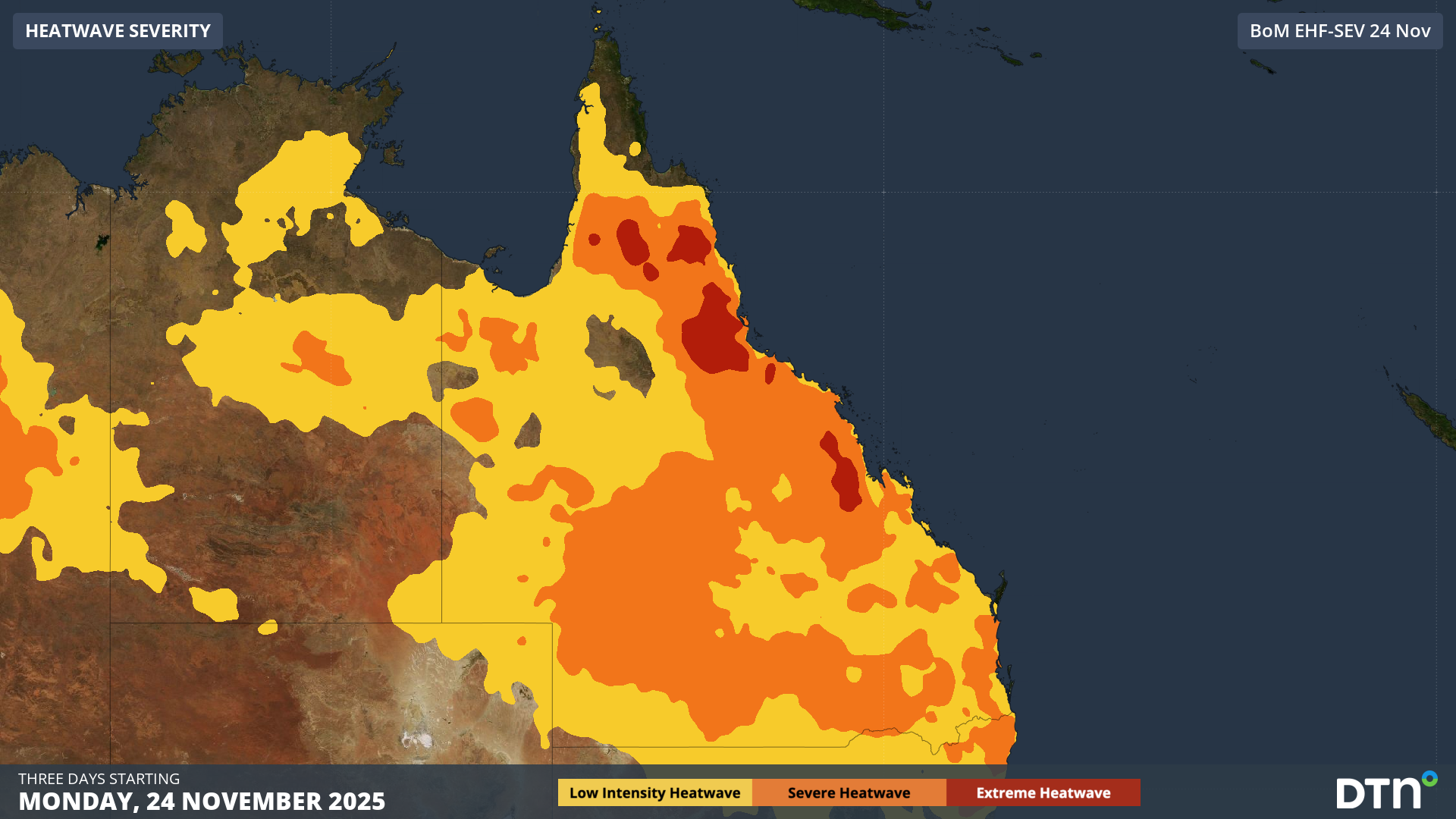
Image: Heatwave conditions across Queensland between Monday and Wednesday, November 24-26, 2025.
DTN APAC has grown to become the outright leader within the Australian energy market, serving wind, solar, hydro, trading, utilities and network companies.
You can’t control the weather, but you can gain precision insights to optimise your response. What lights us up is providing your energy business with tailored weather information to reduce your risk and keep you moving ahead of the curve.
Our services cover all aspects – from wind and solar generation to demand forecasts, wholesale markets to retail so, no matter where your company sits, we have solutions for you. We have worked closely with market participants to create products that meet the evolving needs of the sector, aiming to increase safety and profitability for our customers.
Your customisable Energyzone interface can assess heat/heatwave potential from 14 days out to 12 months. It allows you to benefit from specialised indices for CDD/HDD/apparent temperature/sunshine hours to help accurately predict the demand for electricity. This, along with high-resolution modelling and local knowledge, gives you the most precise information available to make the critical decisions that bolster your production.
Benefit from the timely delivery of accurate weather information, allowing informed and effective decision-making.
How DTN APAC Risk Communicator can inform your decision making with tailored weather and seasonal climate outlook
DTN APAC is a diverse team, with global forecasting, product development and analytics expertise. Couple this with extensive industry experience spanning Aviation to Energy, and we are primed to assist you in strengthening your response to weather impact.
We work hard to identify your operational pressures and tailor our services and products to meet your needs. Concise communication, giving you full situational awareness exactly when you need it, is our focus. We want to reduce weather risk in your operations, every day.
We deliver clear and comprehensive weather data that you can’t get anywhere else, personalised risk assessments and briefings to you and your team, so that your critical decisions can be made with confidence.

We are available 365 days a year, so you always have the timely guidance you require, especially when extreme temperatures hit.
Learn more about our large range of industry leading products and services or email us at sales.apac@dtn.com


