
Severe thunderstorms have formed over parts of Qld and NSW this afternoon, with reports of hail around 7cm in diameter, intense rainfall and flooding and damaging winds.
The combination of a surface and upper-level trough and moisture-laden easterly winds are triggering severe thunderstorms across southeastern Qld and northeastern NSW.
The images below show the severe thunderstorms across the region on Wednesday afternoon.
Image: Himawari-9 satellite image at 2pm AEST on Wednesday, October 9.
This comes after severe thunderstorms lashed southeast Qld on Tuesday afternoon, bringing heavy rainfall to parts of Brisbane and the Sunshine Coast.
On Wednesday afternoon severe thunderstorms developed across parts of NSW and Qld, with reports of giant hail and heavy rainfall:
- 7cm hailstones were observed north of Injune, Qld at around 1:20PM AEST.
- 35.6mm was recorded at Inverell in 30 minutes to 2:46pm.
- Intense rainfall and flooding in Southport, Qld has been reported
Widespread falls of 50 to 70mm have been observed across southeast Qld and Northeast NSW in the past seven hours since 9am.
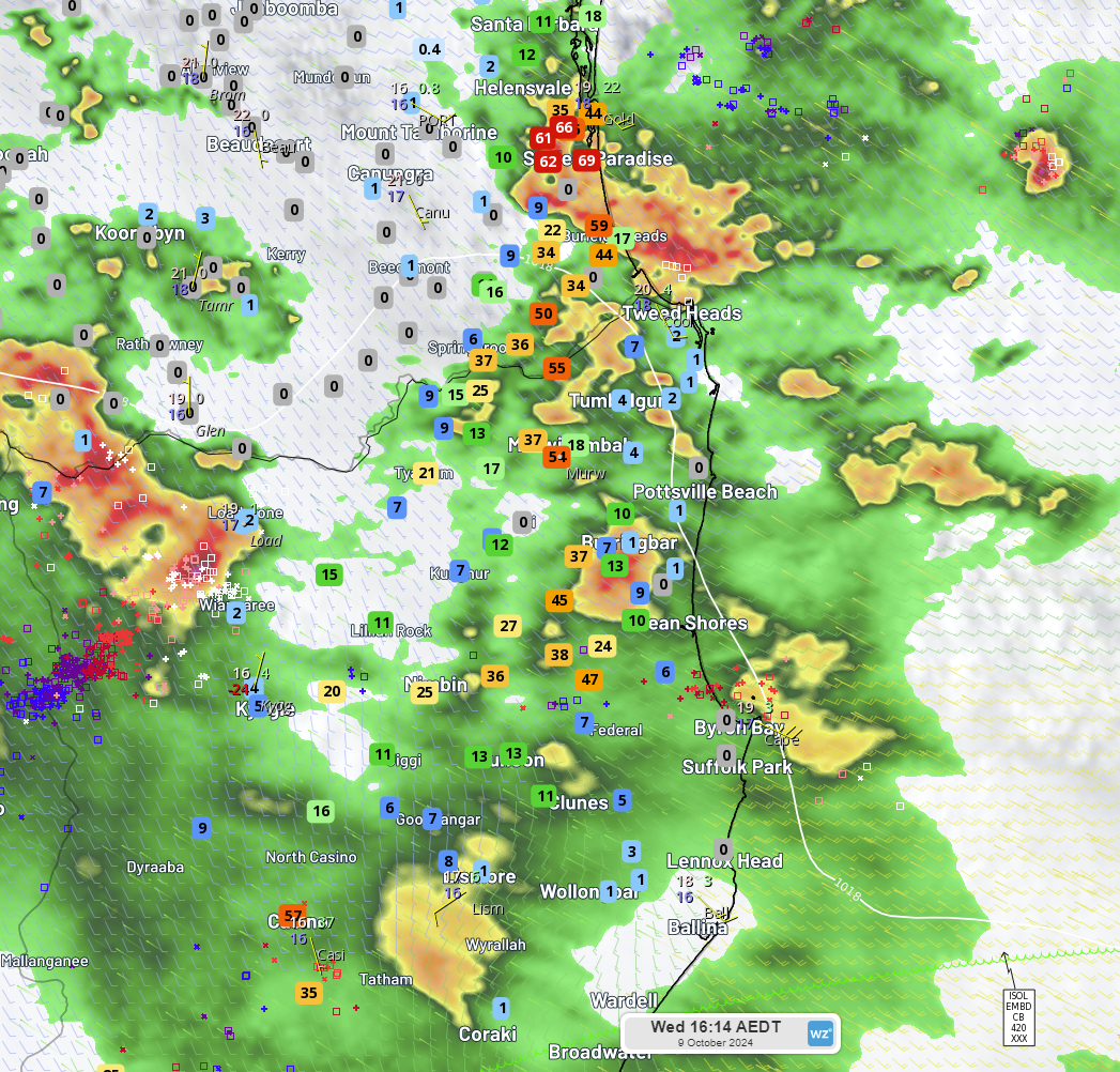
Image: Rainfall observations for seven hours since 9am, Wednesday, October 9.
These thunderstorms are forming over the Qld-NSW Interconnector (QNI) which is likely to impact the transmission capacity between the two states on Wednesday afternoon.
As of 3:30pm, a severe thunderstorm warning is current for very dangerous storms which are likely to produce large, possibly giant hailstones and damaging winds across southern and central Qld. Over the border in NSW, a thunderstorm warning has been issued for heavy rainfall, large hailstones and damaging winds about the Northern Tablelands and North West Slopes.
These thunderstorms have the potential to continue into Wednesday evening, before the risk eases in some areas on Thursday. While storms should clear NSW on Thursday, Qld could see severe thunderstorms develop in central and northeastern Qld on Thursday, with the potential for damaging wind gusts.
Stormtracker is a severe weather solution that can assist you in observing, in real-time, any storm or event that has the potential to impact your business.
Embedded in DTN APAC’ industry interfaces, the system gives you a time advantage when monitoring conditions developing over your infrastructure and location.
Stormtracker is our Global Information System (GIS) tracking tool, providing multiple weather layers and zoom controls overlaid on a map of your location and infrastructure. You can choose a snapshot or full screen view, depending on your requirements. The maps allow you to monitor all weather, and specifically any systems likely to cause risk for your business. You also have the capacity to observe:
- real time lightning and thunderstorm alerts
- localised lightning strike frequency
- official warnings for storm, cyclone, wind, flood and fire
- sentinel hotspot fires and fire agency current incidents
Stormtracker’s radar imagery updates every 10 minutes, so you are always able to respond rapidly to changing conditions. You can customise alerting to notify you when your staff or infrastructure are under threat. With increased situational awareness, your ability to make informed decisions quickly is optimised.
DTN APAC’ experience and intelligence gives you a clear path through complex situations. Let us assist you, offering actionable insight when extreme weather poses risk to your business. For more information, please visit our website or email us at apac.sales@dtn.com.


