
Hot, dry and windy weather causing elevated fire danger and severe heatwave conditions are sweeping across southeastern Australia over the next three days, driving high energy demand and disruption to operations.
Clear skies associated a large and slow-moving high pressure system have allowed hot air to build up over parts of northern, western and central Australia this week. This hot air will spread across southern and southeastern Australia between now and the weekend under the influence of a broad low pressure trough, which will also cause wind to strengthen over several states.
Temperatures rising over all of southeastern Australia in the next few days will bring severe heatwave conditions and high energy demand. The burst of heat and windy conditions also brings disruptive elevated fire danger ratings to parts of SA, Victoria and NSW.
South Australia
North to northwesterly winds are strengthening over SA on Thursday as the low pressure trough deepens over the state. These blustery winds are driving hot inland air towards the south, causing temperatures to reach about 34°C in Adelaide and 36°C around Keith. Further north, temperatures are likely to exceed 40°C in the state’s Pastoral districts on Thursday.
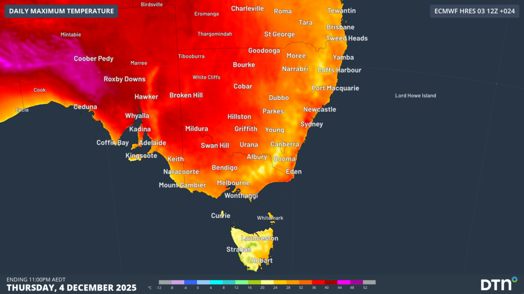
Image: Forecast maximum temperatures on Thursday, December 4, 2025.
The combination of heat, blustery winds and low relative humidity have caused Extreme fire danger ratings over central and eastern part of SA on Thursday. Total fire bans have been declared in eight of the state’s 15 districts:
- Eastern Eyre Peninsula
- Flinders
- Mid North
- Yorke Peninsula
- Mount Lofty Ranges
- Riverland
- Murraylands
- Upper South East
Milder southerly winds will drop temperatures and fire danger ratings in the state’s south from Thursday afternoon into Friday, although intense heat will linger in the north of SA until Saturday. While Adelaide is only forecast to reach 22°C on Saturday, some northern pastoral areas could reach the high-40s on Saturday afternoon.
Victoria
All of Victoria will be affected by a surge of hot northwesterly winds on Thursday, with temperatures forecast to reach 34°C in Melbourne, 36°C in Mallacoota and 38°C in Mildura. Extreme fire danger ratings are likely to develop in parts of the Mallee, Wimmera and Northern Country districts amid this heat on Thursday, with total fire bans declared for all three districts.
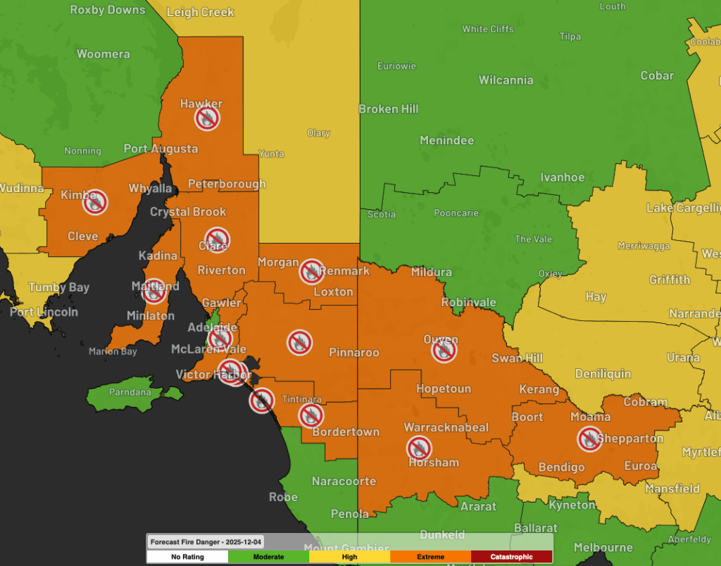
Image: Forecast fire danger ratings and total fire bans as seen on the DTN APAC Stormtracker dashboard on Thursday, December 4, 2025.
Milder southwesterly winds will spread through southern Victoria from Thursday afternoon into Friday, although northern Victoria will remain hot on Friday before cooling over the weekend. Extreme fire danger is expected to linger in parts of the Mallee and Northern Country districts on Friday.
New South Wales
Hot air will spread over NSW from Friday into the weekend, causing a spike in temperatures and fire danger ratings.
Sydney’s daily maximum temperatures are forecast to reach 30°C on Thursday, 35°C on Friday and 36°C on Saturday. The city’s western suburbs will be several degrees warmer, likely reaching around 40-41°C on Friday and Saturday. Temperatures will also reach the low to mid-40s in western NSW on Friday and Saturday.
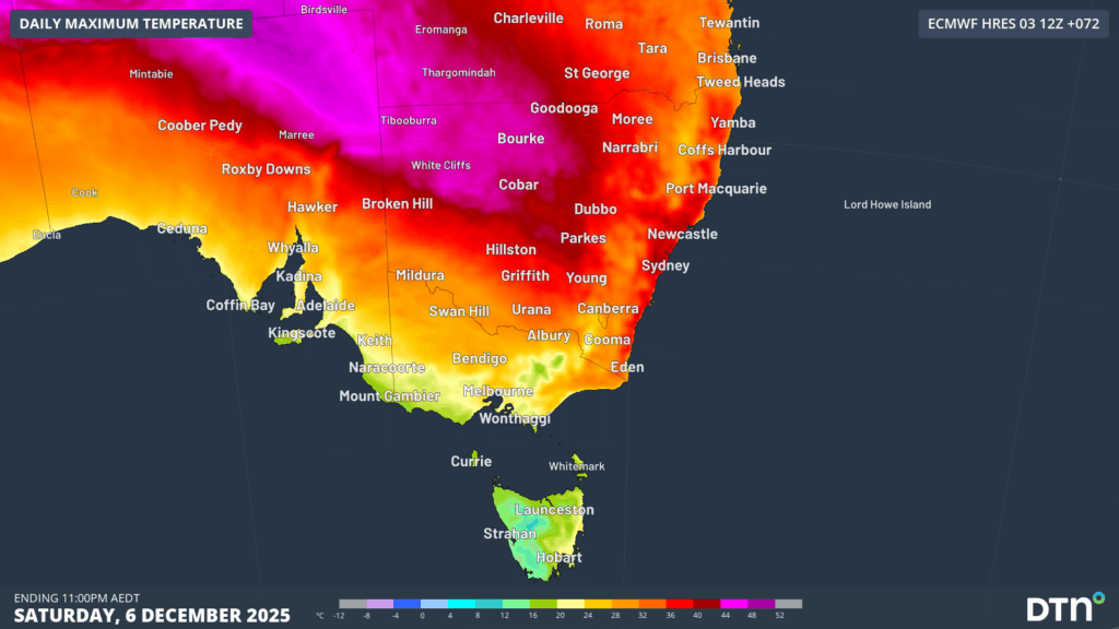
Image: Forecast maximum temperatures on Saturday, December 6, 2025.
Increasingly warm overnight conditions over this period, with Sydney’s minimum temperatures forecast to only drop to 19°C on Friday, 23°C on Saturday and 20°C on Sunday, will prevent overnight relief from the heat. Severe heatwave conditions are forecast across the period, with high energy demand expected on Friday and Saturday as energy customers turn on A/C units to cool off.
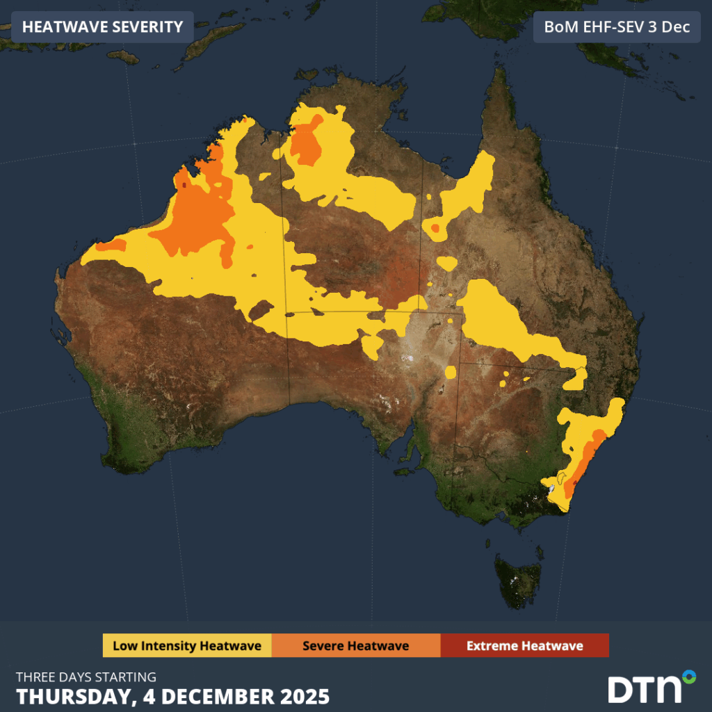
Image: Forecast heatwave conditions between Thursday and Saturday, December 4-6, 2025.
Extreme fire danger ratings are likely to develop in parts of southern NSW on Friday and central, eastern and northern NSW on Saturday. Saturday’s Extreme fire danger is likely to affect parts of the Greater Sydney, Greater Hunter and Illawarra/Shoalhaven districts.
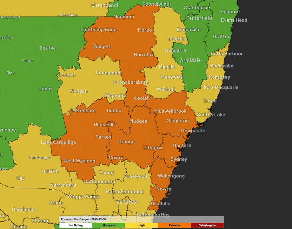
Image: Forecast fire danger ratings as seen on the DTN APAC Stormtracker dashboard on Saturday, December 6, 2025.
Thunderstorms igniting fires possible
While much of southeastern Australia will experience hot and windy weather over the next few days, some places could also see thunderstorms.
The atmosphere is too dry for widespread storms and heavy rain, so storms are likely to be scattered and fast-moving. The biggest threats from these storms will be damaging and possibly destructive winds, and dry lightning, which could ignite bush or grass fires.
Heat and thunderstorm activity will also spread further north into northern NSW and Queensland on Sunday and Monday.
How DTN APAC Services Fire-Prone Outdoor Industries
Working in often challenging conditions across high-risk outdoor operations including forestry, emergency services, mining, rail, and utilities, our consolidated weather services ensure full situational awareness for you and your team.
DTN APAC serves fire-prone outdoor industries, delivering trusted weather data and severe weather alerting to maintain safety, protect your assets and underpin your operational planning.
Reinforce your Prevention, Preparedness, Response and Recovery (PPRR) efforts with our tailored services.
Prevention: Utilise our seasonal outlooks and daily forecasting to identify and implement prevention measures. Understand the climate risks affecting your operations. Calculate optimal timing for maintenance activities, vegetation management, and scheduled shutdowns.
Preparedness: Gain understanding of bushfire risk in the days, weeks and months leading up to peak fire season. Use DTN APAC’s seasonal outlooks and 14-day forecasting to plan workforce deployment, equipment positioning, and preventative operations such as controlled burns or asset maintenance.
Response: We deliver fire danger forecasts and provide nowcasting and forecasting of severe weather events, including thunderstorm/lightning detection and alerting, to give you full situational awareness of emergency conditions likely to impact your operations and infrastructure.
Recovery: Assess the weather risks affecting post-incident recovery and restoration processes. Utilise post-event analysis reports to support insurance claims, evaluate operational response effectiveness, and inform future risk management strategies.
We work to bring you full situational awareness so you can mitigate risk, ensure workforce safety, and maintain operational continuity across your outdoor assets.
Learn more about our large range of industry leading products and services or email us at sales.apac@dtn.com
See our Case Study on how Tasmania Fire Service (TFS) improved lightning detection and continued optimising preparations for challenging fire seasons ahead with DTN APAC’s full suite of solutions.


