
June nights were absolutely frigid in Canberra and parts of inland New South Wales, with average monthly minimums the coldest in decades in several locations driving high energy demand.
Let’s start with the national capital, which shivered through a June average minimum of –2.7°C, which made it the coldest June for overnight temperatures in 41 years.
Canberra nights were 3.8°C degrees colder on average than the long-term June average minimum of 1.1°C. This was the largest anomaly anywhere in NSW or the ACT.
In June 2025 in Canberra:
- 23 of the 30 minimum temperatures were below zero.
- The mercury fell to –5°C or lower on 11 nights, including two separate streaks of five nights in a row.
- The coldest night was –7.6°C on June 21 – the first of three consecutive nights when temperatures fell below –7°C.
The coldest temperatures recorded anywhere in Australia so far this year were –10°C on June 21 at Goulburn Airport, about an hour northeast of Canberra, and the same temperature at Cooma on June 22.
The average June 2025 minimum at Goulburn Airport was –2.2°C which was 3.6°C below the long-term average, while Cooma’s average June minimum of –4°C was 2.7°C below average.
And the chill extended much further north, with multiple locations on the Central and Northern Tablelands and nearby forecast districts experiencing colder-than-average nights in June, while many coastal and Sydney area weather stations were also significantly colder than usual at night.
But the biggest anomalies across NSW and the ACT were in inland regions on the plains and tablelands.
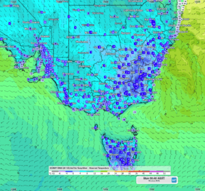
Image: Temperatures across southeast Australia at 6:40am on the final morning of June 2025, with dark blue areas showing temperatures in the range of 0°C to –4°C. These sorts of readings occurred frequently in many areas throughout the month, with the mercury often dipping even lower.
Why such cold June nights in the ACT and large parts of NSW?
Clear, windless conditions are the classic ingredients for cold frosty nights inland, and there were plenty of them in June.
Canberra had slightly less than two thirds of its average June rainfall, while many other parts of inland NSW were also relatively dry.
June also saw prolonged periods of very dry, cold air at the 850mb level, a low-level atmospheric pressure layer sitting approximately 1500m above sea level.
This cold, dry air sank at night, causing temperature inversions (where the air is colder at lower altitudes than higher altitudes).
A good example of a temperature inversion occurred on the night of June 21 (mentioned above) when Goulburn Airport plummeted to –10°C. That same night, Australia’s highest weather station at the top of Thredbo stayed above zero.
Slightly warmer minimums can be expected across coastal and inland NSW this week with moist air driven onshore by winds circulating around the East Coast Low off the NSW coast.
DTN APAC has grown to become the outright leader within the Australian energy market, serving wind, solar, hydro, trading, utilities and network companies.
You can’t control the weather, but you can gain precision insights to optimise your response. What lights us up is providing your energy business with tailored weather information to reduce your risk and keep you moving ahead of the curve.
Our services cover all aspects – from wind and solar generation to demand forecasts, wholesale markets to retail so, no matter where your company sits, we have solutions for you. We have worked closely with market participants to create products that meet the evolving needs of the sector, aiming to increase safety and profitability for our customers.
Your customisable Energyzone interface can assess heat/heatwave potential from 14 days out to 12 months. It allows you to benefit from specialised indices for CDD/HDD/apparent temperature/sunshine hours to help accurately predict the demand for electricity. This, along with high-resolution modelling and local knowledge, gives you the most precise information available to make the critical decisions that bolster your production.
Benefit from the timely delivery of accurate weather information, allowing informed and effective decision-making.
Learn more about our large range of industry leading products and services or email us at sales.apac@dtn.com
Thumbnail source: SujaysPhotography (@sujays_photography_brisbanenow on Instagram)


