Prosper in a dynamic world
Search

Coldest day in years, frost on the way in WA


Parts of southwestern Australia just shivered through their coldest day in more than a decade as a polar air mass hit WA.

The sequence of satellite images below shows a cold front and trailing polar air mass passing over the southwest of WA during the last two days.

Video: Composite infrared/visible satellite images over the past 48 hours, showing cold air spreading over southwestern Australia on Monday and Tuesday.

On Tuesday, Perth only reached a maximum temperature of 12.4ºC, which is about 7ºC below average for this time of year. This made Tuesday the city’s coldest day in two years and its fourth coldest day this century.

Nearby, Bickley’s top temperature of 9.4ºC on Tuesday was its coldest day since 2005 and its coldest August day in records dating back to 1994.

These abnormally low temperatures were made possible by a cold air mass combined with frequent rain and cloud cover, with Perth collecting close to 40mm of rain during the 48 hours to 9am on Wednesday. In the far south of WA, some of Tuesday’s precipitation even fell as snow on the Stirling Range.

Daytime temperatures will gradually warm up over the next few days, with Perth forecast to reach about 17ºC on Wednesday and up to 21ºC by Friday. However, clear skies and lighter winds will cause very cold overnight temperatures across southern WA over the next few nights, with frost likely over the state’s southern inland.

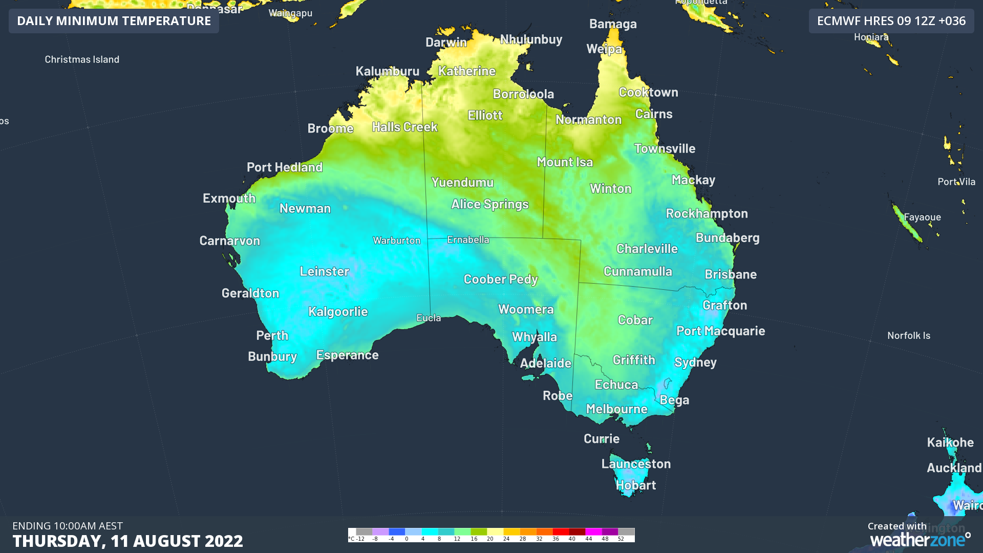
Image: Forecast minimum temperatures on Thursday morning according to the ECMWF-HRES model.

For more information on our energy forecasts, please contact us at bsuiness@weatherzone.com.au.

Latest news

Satisfy your weather obsession with these news headlines from around the nation, and the world.

Perth sets rainfall streak not seen in 18 years as water storage levels fall

For four months in a row, Perth has exceeded its average monthly rainfall – the first time this has happened in the traditionally wet winter and spring period since 2007. Perth reached its September average of 79.3mm during light showers on Tuesday and Wednesday. Another 13.2mm of rain then fell in the 24 hours to […]

DTN remote sensing captures rain and thunderstorms lashing Solomon Islands

Aviation, mining and shipping industries in the Solomon Islands and other South Pacific nations are often unable to use traditional radar to warn of incoming storms that disrupt operations and put workers in harm’s way. DTN APAC offers a suite of remote sensing weather solutions that give businesses and industries in remote areas around the […]

Negative Indian Ocean Dipole officially underway – here’s what it means for Australian businesses and industries

A negative Indian Ocean Dipole (IOD) event is now underway, increasing the likelihood of above average rain over large parts of Australia in the coming months. What is the Indian Ocean Dipole (IOD)? The IOD is an index used to monitor sea surface temperatures across the tropical Indian Ocean. It’s an important index for the […]

La Niña more likely this year after BoM switches to new index – what does this mean for Australian businesses?

The likelihood of La Niña occurring in 2025 has increased due to a change in the way the Bureau of Meteorology calculates sea surface temperature anomalies in the tropical Pacific Ocean. What is La Niña? La Niña refers to a distinct pattern of sea surface temperatures across the tropical Pacific Ocean. When La Niña is […]