Prosper in a dynamic world
Search

Australia’s coldest January in 21 years

Australia just experienced its coolest start to a year since 2002 as the ongoing influence of La Nina helped suppress temperatures over large parts of the country.

The national mean temperature in Australia during January was equal to the 1961 to 1990 average, making it the country’s coolest January in 21 years.

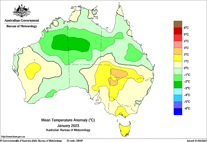
Image: Mean temperature deciles in January 2023. Source: Bureau of Meteorology

Daytime maximum temperatures were particularly cool across large swathes of northern and central Australia, thanks to abundant cloud cover, frequent rain and the cooling effect of water evaporating from the sodden landscape.

Australia’s mean maximum temperature last month came in 0.3ºC below the 1961 to 1990 average, also the coolest national mean maximum since 2002.

Image: Cloud and lightning near Bendigo, Vic in early January 2023. Source: @chxute74 / Instagram

Rainfall was mixed across Australia in January, with above average falls in the north and patches of drier than usual weather in the east and south.

Australia's coldest January in 21 years

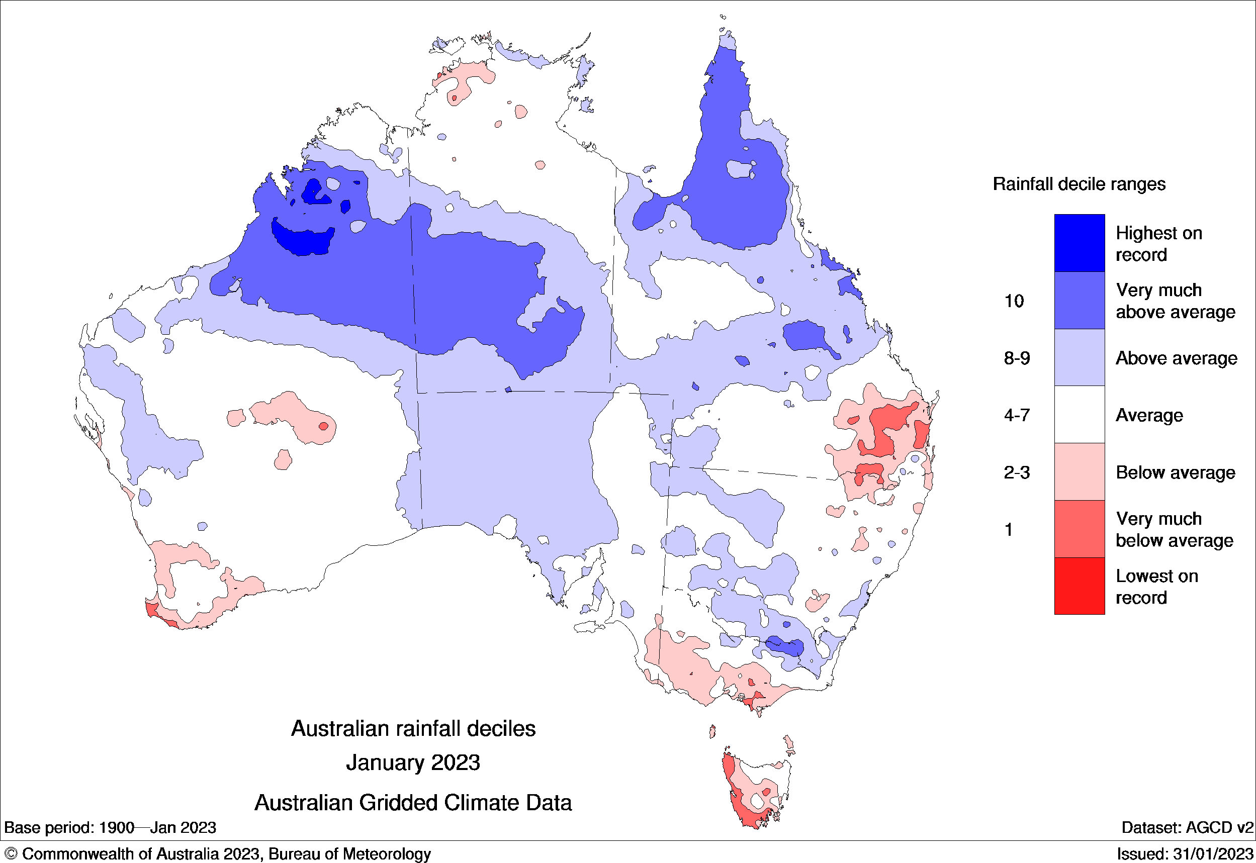
Image: Rainfall deciles in January 2023. Source: Bureau of Meteorology

When averaging rainfall across the country, Australia just had its wettest January in six years.

DTN APAC can provide climate updates tailored to your business, whether its local or international. To request a briefing or to find out more please email us at apac.sales@dtn.com.

Latest news

Satisfy your weather obsession with these news headlines from around the nation, and the world.

How does DTN help businesses monitor bushfire induced pyrocumulonimbus thunderstorms that ignite more fires?

Intense heat from bushfires during elevated fire danger days can trigger fire-induced pyrocumulonimbus thunderstorms that ignite additional fires. In early January 2026, an extreme heatwave sweeping over southeastern Australia brought catastrophic fire danger to Victoria. Intensely hot bush and grass fires spread erratically and quickly in hot, dry and gusty winds, with pyrocumulonimbus generating lightning, […]

Active seas to the north and east of Australia disrupting port and maritime operations

Seas to the north and east of Australia are experiencing periods of increased activity this week, leading to disruptions to port, maritime and offshore operations. Intense and hazardous Tasman Sea Ocean conditions across NSW’s South Coast rapidly deteriorated last Friday as a deep feed of easterly winds whipped up large and dangerous seas. The Batemans […]

Transport, emergency and energy industries flooded across Greater Sydney with weekend deluges

Transport, emergency, energy and port industries in eastern NSW and Sydney were impacted by significant flash flooding with intense and heavy rainfall this weekend. Rainfall rates between 80 and 140mm in one to three hours were registered across parts of Sydney’s Northern Beaches and Central Coast on Saturday afternoon and evening. In some areas, these […]

DTN Dangerous Thunderstorm Alerts in action with severe thunderstorms disrupting Perth industries

Severe thunderstorms impacted southwest WA and the Perth region on Sunday, December 14, 2025, triggering Dangerous Thunderstorm Alerts (DTA) by DTN for industries and businesses in the region. DTN operates Dangerous Thunderstorm Alerts (DTA) which alert businesses and industries to thunderstorms based on intensity and movement. These alerts provide advanced notice of thunderstorms moving into […]