
Australia just had its warmest spring on record with a mean temperature more than 2°C above the long-term average.
The national mean temperature in spring 2024 – which is the average of 112 weather stations spread out across the country – was about 24.58°C. This is exceptionally high for spring, coming in at 2.08°C above the 1961-90 long-term average.
This huge anomaly made spring 2024 Australia’s warmest spring in records dating back to 1910, beating the previous record of +2.03°C from 2020.
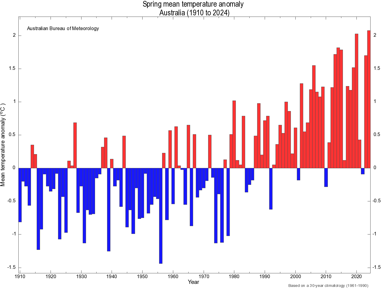
Image: Australia’s spring mean temperature anomalies between 1910 and 2024. Source: Bureau of Meteorology.
Nowhere in Australia had a cooler-than-average spring, and most of the country experienced average spring temperatures that were in the top 10 percent of historical records.
The map below shows the observed mean temperature deciles for Australia in spring 2024. The orange shading shows that temperatures were above average almost everywhere, while the darkest shading reveals that parts of four states and one territory experienced record-breaking warmth during the season.
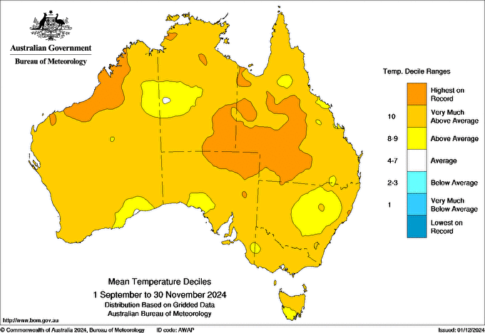
Image: Observed mean temperature deciles during spring 2024. Source: Bureau of Meteorology
Here’s how spring 2024 ranked out of 115 years of observations (1910 to 2024) for each state and territory, based on the mean temperature anomaly relative to 1961-90:
- Queensland: +2.47°C – warmest on record
- WA: +2.02°C – 3rd warmest on record
- NSW/ACT: +2.17°C – 8th warmest on record
- SA: +2.15°C – 5th warmest on record
- NT: +1.70°C – 4th warmest on record
- Victoria: +1.60°C – 6th warmest on record
- Tasmania: +0.76°C – 9th warmest on record
Last season’s exceptional air temperature anomaly was partially driven by the influence of abnormally warm oceans surrounding the country. While the final data isn’t yet available for the whole season, sea surface temperatures in the Australian region were running at record-breaking levels through the middle of the season and have remained well above average in recent weeks.
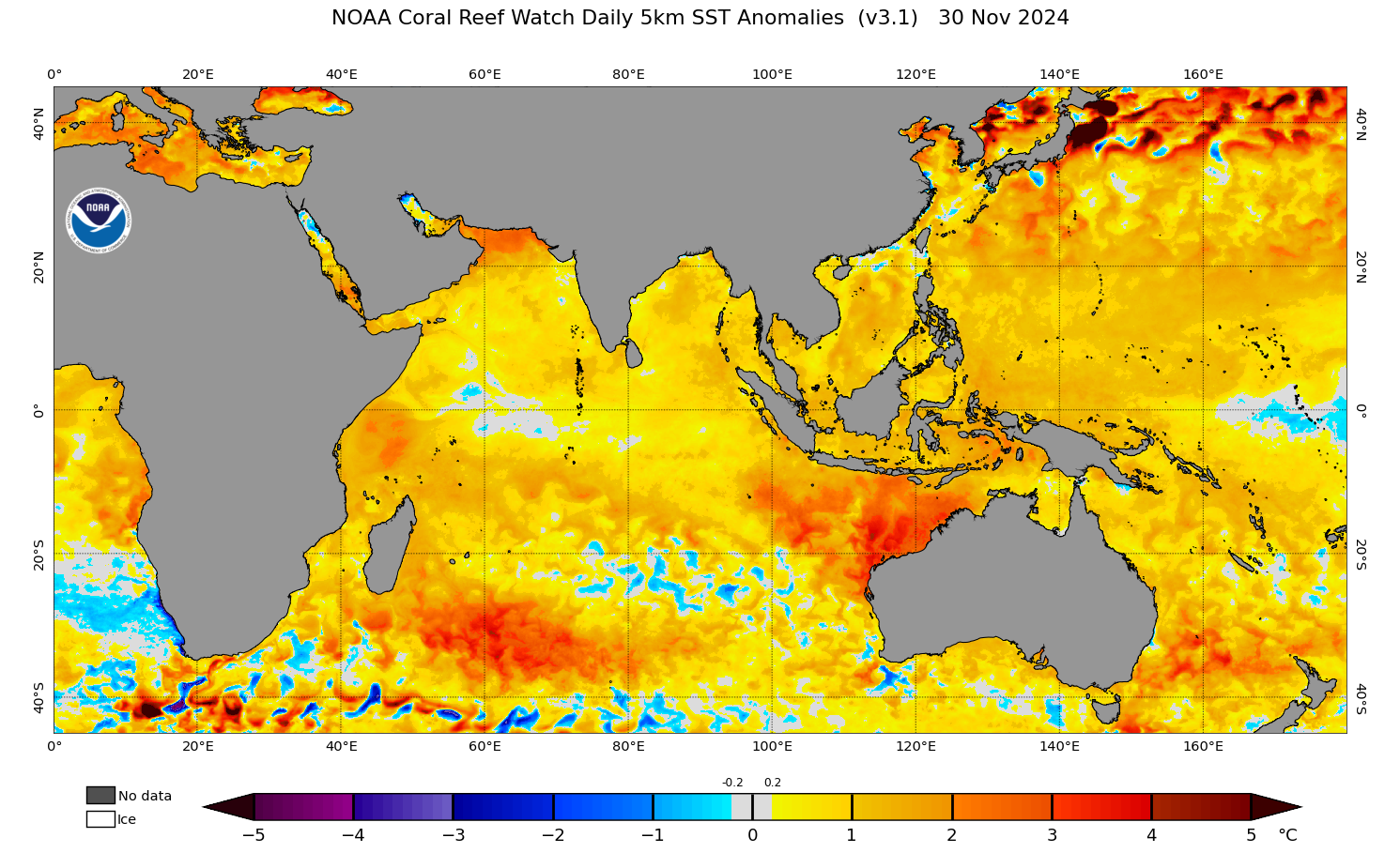
Image: Sea surface temperature anomaly on the final day of spring 2024, showing abnormally warm water surrounding Australia. Source: NOAA
Australia’s record-breaking spring warmth is one piece of a larger puzzle that reveals a broader picture of global warming in 2024. According to the World Meteorological Organization, 2024 is on track to become Earth’s hottest year on record.
DTN APAC supplies precise weather intelligence to over 75% of the National Energy Market (NEM); and is the trusted provider for the Australian Energy Market Operator (AEMO).
Weatherzone’s next-generation nowcasting and forecasting system, OpticastTM, is independently proven to outperform other industry models, allowing energy traders to respond rapidly to changing conditions. From 14 day forecasting to seasonal outlooks, you have access to complete and powerful weather intelligence giving you the confidence to make the best call.
Meeting the needs of the changing market, Weatherzone utilises high-resolution modelling and local knowledge to provide 5-min granularity observations and forecasts, optimising your market bidding and maximising your profits. These, coupled with briefings from our energy meteorologists, give you full awareness of the associated risk.
Benefit from specialised indices such as apparent temperature, Cooling/Heating Degree Days (CDD/HDD) and Effective Degree Days (EDD) to help accurately predict demand. You can get a clear picture of forecast conditions across the market and quickly assess heat/heatwave potential from 14 days out to 12 months
No matter where your energy trading focus lies, we have the power generation and weather insights to inform your critical decisions, keeping you ahead of the curve. For more information please visit our website or email us at sales.apac@dtn.com.


