More heavy rain is on the horizon for already saturated areas in central and eastern Australia this week, with flooding and severe thunderstorms likely.
Large areas of central and eastern Australia have already seen 2 to 4 times their average November rainfall and another month’s worth is on the way this week.

Image: Observed November rainfall percentages, after the first 21 days of the month. Source: Bureau of Meteorology.
Over the last three weeks, an abundance of atmospheric moisture has interacted with a series of series of upper-level troughs to produce widespread, persistent and heavy rain on Australia.
This moisture was enhanced by a La Niña in the Pacific Ocean and warmer-than-average sea surface temperature near Australia.
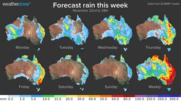
This wet weather pattern will continue over a large portion of Australia this week, with rain and thunderstorms set to impact part of every state and territory. There should also be enough rain to cause flooding in at least three states.

Image: Forecast accumulated rain this week, according to the ECMWF-HRES model.
On Monday, rain and thunderstorms will affect south-eastern QLD and northeast NSW as an upper-level low pressure system interacts with humid easterly winds.
Early on Monday, QLD’s Ma Ma Creek saw 72mm in one hour to 7am during a severe storm, while Gatton and Little Egypt observed 30-minute rainfall rates of 40-45mm around the same time.
Severe storms are likely to continue in south-eastern and central QLD and far northern NSW into Monday afternoon, with heavy rainfall which may lead to flash flooding the main concern. However, damaging to destructive winds and hail are also a risk in southeast and central QLD.
Showers and a few storms will linger over eastern Australia on Tuesday, although they will generally be less intense than Monday.
Meanwhile, another upper-level trough moving over Australia from west to east will cause rain and thunderstorms over WA on Monday, before spreading into parts of SA, VIC and NSW on Tuesday.
On Wednesday, the upper-level trough will develop into a cut-off low and move further east, allowing it to interact with moisture-laden air sitting above the eastern half of the country.
This will produce three days of widespread rain and thunderstorms over the eastern half of Australia between Wednesday and Friday.

Image: ECMWF-HRES model forecast 24-hour rain on Wednesday November, 24.
Rain and thunderstorms will affect the eastern half of Australia on Wednesday, including large areas of SA, VIC and NSW, the ACT and QLD on Wednesday.
The greatest chance of heavy rain and severe storms on Wednesday will be along a corridor from the NT down to VIC, including the eastern inland of SA and NSW.

Image: ECMWF-HRES model forecast 24-hour rain on Thursday November, 25.
Rain and storm activity will intensify across QLD, NSW, the ACT, VIC and eastern SA on Thursday as the upper-level low moves further east, causing a surface trough and low-pressure system to deepen near the surface.
Heavy rain and severe thunderstorms are a high risk in VIC, NSW, the ACT and QLD on Thursday, with both flash and riverine flooding possible. Widespread 24-hour totals of 20-40mm are likely from central QLD down to VIC, while thunderstorms could produce localised falls of 50-100mm.

Image: ECMWF-HRES model forecast 24-hour rain on Friday November, 26.
The upper low is set to move further east on Friday, causing rain and thunderstorms to focus on eastern VIC, NSW, the ACT and eastern districts of QLD. These areas could see another 20-40mm on Friday alone, with some areas potentially receiving up to 100mm with thunderstorms.
By the weekend, the system is expected to move into the Tasman Sea, causing rain to ease significantly. However, lingering showers will remain for some areas along the east coast of the country over the weekend.
This week’s rain will be falling over already saturated catchments in some parts of the country. This will increase the likelihood of surface runoff and flooding, particularly in areas that see heavy rain over a short period of time.

Image: Root zone soil moisture anomaly during the first 21 days of November. This represents the percentage of available water content in the top 1 metre of the soil profile, relative to the long-term average. Credit: Bureau of Meteorology
As of Monday morning, moderate to major flooding was occurring in parts of Central West and Northern NSW as a result of recent rainfall. These areas are both likely to see more heavy rain this week.
This week’s rain, cloud and cool southerly winds are likely to cause temperatures to plummet from Thursday across south-eastern Australia. The cloud cover will also reduce solar output for at least three days across south-eastern Australia. For more information on Weatherzone’s solar output, rain, thunderstorm and wind forecasting, please contact us at apac.sales@dtn.com.


