Prosper in a dynamic world
Search

A very tropical Wednesday in Melbourne

It’s going to be 33 degrees, humid and pretty uncomfortable in Melbourne this Wednesday, which you undoubtedly know already if you’re in town.

Indeed the whole state of Victoria would be feeling a lot like Queensland today, and that’s basically because the weather is coming from there.

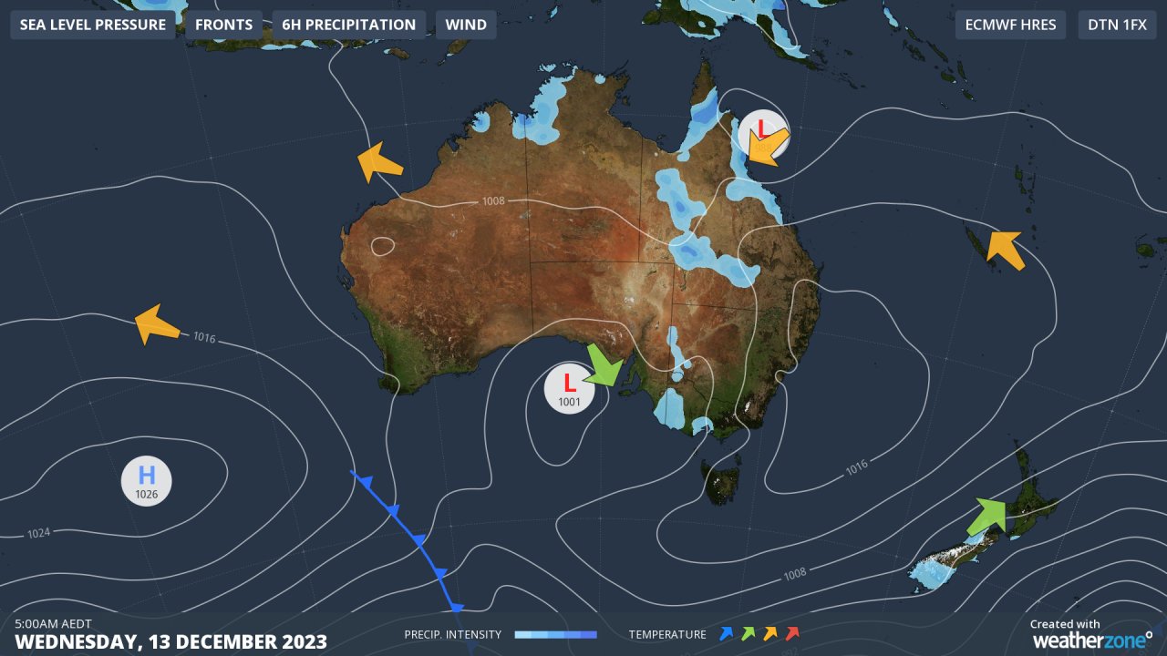
Take a look at the chart below. It shows a cut-off low centred over the Great Australian Bight which is dragging warm moisture-laden air from Queensland all the way down to Victoria and even Tasmania.

A very tropical Wednesday in Melbourne

What’s most remarkable about the weather in Melbourne this Wednesday morning is the extremely high dew point.

Dew point is the temperature at which dew would form if the air cooled to that level, and it’s usually significantly lower than the air temperature when it is not raining.

But in Melbourne at 9:30 am on Wednesday, the air temp was 24.8°C while the dew point was 21.3°C. The high dew point shows just how much moisture is available in the atmosphere right now.

That’s why showers and thunderstorms are likely this afternoon, and there is a good chance the storms will be severe given all the hot air and moisture about. We’ll keep you posted and please check our warnings page for the latest.

For more information on Weatherzone’s energy forecasts, please contact us at apac.sales@dtn.com.

Latest news

Satisfy your weather obsession with these news headlines from around the nation, and the world.

How does DTN help businesses monitor bushfire induced pyrocumulonimbus thunderstorms that ignite more fires?

Intense heat from bushfires during elevated fire danger days can trigger fire-induced pyrocumulonimbus thunderstorms that ignite additional fires. In early January 2026, an extreme heatwave sweeping over southeastern Australia brought catastrophic fire danger to Victoria. Intensely hot bush and grass fires spread erratically and quickly in hot, dry and gusty winds, with pyrocumulonimbus generating lightning, […]

Active seas to the north and east of Australia disrupting port and maritime operations

Seas to the north and east of Australia are experiencing periods of increased activity this week, leading to disruptions to port, maritime and offshore operations. Intense and hazardous Tasman Sea Ocean conditions across NSW’s South Coast rapidly deteriorated last Friday as a deep feed of easterly winds whipped up large and dangerous seas. The Batemans […]

Transport, emergency and energy industries flooded across Greater Sydney with weekend deluges

Transport, emergency, energy and port industries in eastern NSW and Sydney were impacted by significant flash flooding with intense and heavy rainfall this weekend. Rainfall rates between 80 and 140mm in one to three hours were registered across parts of Sydney’s Northern Beaches and Central Coast on Saturday afternoon and evening. In some areas, these […]

DTN Dangerous Thunderstorm Alerts in action with severe thunderstorms disrupting Perth industries

Severe thunderstorms impacted southwest WA and the Perth region on Sunday, December 14, 2025, triggering Dangerous Thunderstorm Alerts (DTA) by DTN for industries and businesses in the region. DTN operates Dangerous Thunderstorm Alerts (DTA) which alert businesses and industries to thunderstorms based on intensity and movement. These alerts provide advanced notice of thunderstorms moving into […]