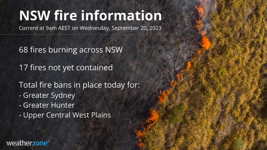
The heatwave continues in New South Wales, with summer-like temperatures and summer-like fire danger.
On Thursday morning, there were 68 bushfires burning, 17 of them uncontained, as dangerous winds pick up strength ahead of a southerly change due later on Wednesday.
The NSW Rural Fire Service has declared a total fire ban in three regions: Greater Sydney, Greater Hunter, and Upper Central West Plains. Please click here for a reminder of the total fire ban rules.
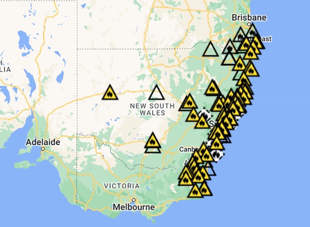
Image: That’s a lot of fires for September. Source: NSW RFS.
Meanwhile the unprecedented September hot spell continues to break records both for high temperatures, and for the duration of unseasonably hot temperatures.
- We’ve already seen Sydney equal its hottest September temperature in over 100 years of records, while Sydney Airport exceeded the old record.
- This Wednesday, Sydney is likely to register back-to-back 34-degree days for the first time on record in September. Indeed it will be the first time the mercury has soared that high on any two September days.
- Penrith in the city’s outer west could give the September high temp record of 37.3°C a nudge. As we were writing this story at 10 am, it had already touched 31.7°C.
There have also been some extremely warm minimum temperatures in the current long-lasting heatwave.
- While Sydney’s minimum of 20.5°C just before 9 pm on Tuesday evening was not a September record, the night actually warmed after that.
- At 3 am on Wednesday, Sydney was sitting on 22.8°C while Darwin was just 22.3°C at 3 am local time.
It’s not often that Sydney would be warmer than Darwin in the middle of a September night, or the middle of any night in any month, which illustrates how much hot air has been pushed into eastern NSW this week.
But there’s NSW relief in sight…
A southerly buster will sweep northwards along the NSW coast later this Wednesday. The good news is it will cool things down significantly and effectively signal the end of the heatwave.
The bad news for fire authorities and people with property in fire-affected or fire-prone areas is that it will be a mostly dry change, with only light showers expected along parts of the coastal fringe.
Meanwhile the heat will edge its way into southeast Queensland on Thursday, bringing temps in the low-to-mid thirties to Brisbane and the Gold Coast, with the mercury reaching the mid-to-high thirties further inland in places like Ipswich.
Please check the Weatherzone warnings page, and the latest warnings on the NSW Rural Fire Service page and the Qld Fire and Emergency Services page.
How can Weatherzone help?
Working in often severe conditions in the high-risk fields of forestry and emergency, our consolidated weather services can ensure full situational awareness for you and your team.
DTN APAC serves the forestry and emergency sectors, delivering trusted weather data and severe weather alerting to maintain safety, protect your assets and underpin your planning.
Weatherzone’s trusted nowcasting and forecasting system, OpticastTM, is independently proven to outperform other industry models, allowing you to respond rapidly to changing conditions. Opticast can ingest data from your on-site weather observation equipment, ensuring your forecast is customised to your local microclimate. From nowcasting and 14 day forecasting to seasonal outlooks, you have powerful, hyper-local weather alerting and intelligence, giving you decisive confidence when it’s most needed.
With lightning a prominent cause of forest fires throughout Australia, Weatherzone’s Total Lightning Network offers real-time detection and unsurpassed accuracy of lightning strikes to <200m. Based on a vast sensor network, both intra-cloud and cloud-to-ground strikes are located, ensuring you are alerted when severe weather is building and threatening your teams, assets and infrastructure. When volatile conditions increase the ferocity of fire it’s imperative you have lead-time to enact safety plans, keeping your people out of harm’s way.
Your weather intelligence is accessible across all devices in your network via our Weatherguard App, and your customisable interface.
We are there for you when you need us the most – 24/7, 365 days a year. For more information, please contact us at apac.sales@dtn.com


