
A late-winter thunderstorm outbreak is unfolding across eastern and southeastern Australia today, with severe thunderstorms likely in several states.
As the sun rose on Monday morning, thunderstorms were stretching from the eastern inland of the NT down to western VIC, spanning close to 3000 km in distance.
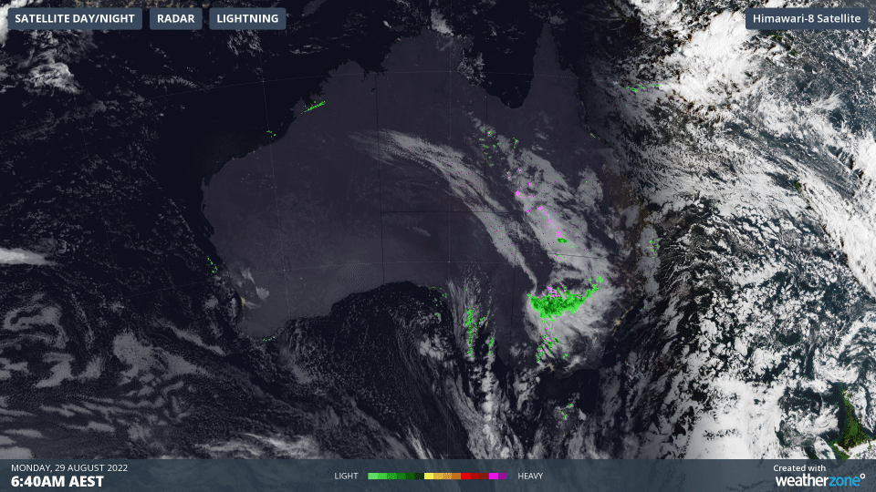
This morning’s thunderstorms were unusually active for a late-winter’s morning in Australia, with large thunderstorm outbreaks like this more commonly occurring in the afternoon during spring or summer.
Monday’s storms are being caused by a broad low pressure trough and cold front interacting with moisture-laden air and an unstable atmosphere. This instability is being enhanced by a large temperature contrast between an unseasonably warm air mass over the Australian continent encountering a much colder pool of air travelling up from the Southern Ocean.
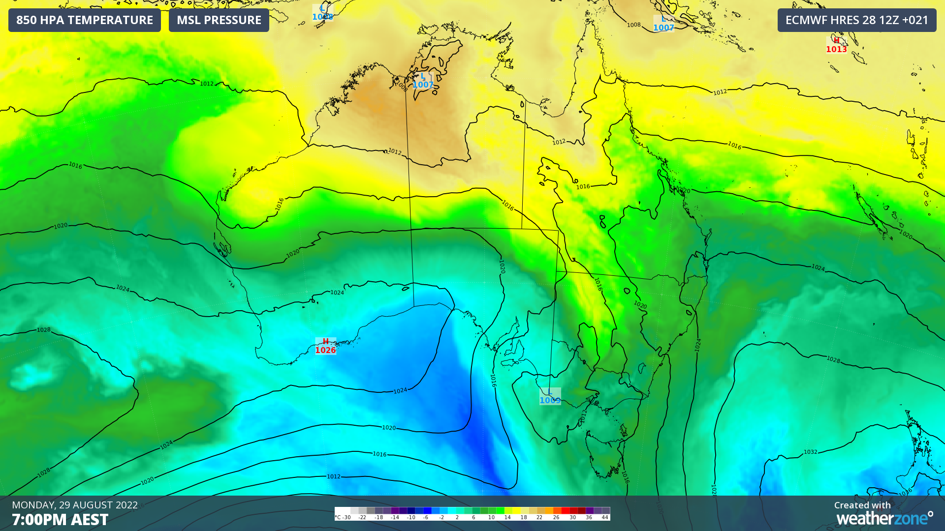
Image: Air temperature at around 1.5 km elevation and mean sea level pressure at 7pm AEST on Monday, August 29, according to the ECMWF model.
Rain and thunderstorms will continue to spread over eastern and southeastern Australia on Monday afternoon and evening, likely affecting parts of the NT, QLD, NSW, the ACT, VIC, SA and TAS.
Some of Monday’s storms could produce damaging winds, large hail and heavy rain, most likely in a corridor extending from southwest QLD, down through far western NSW and into western VIC. A few supercell thunderstorms could also develop in western NSW from Monday afternoon, possibly causing destructive winds and giant hail.
While the most intense thunderstorms are likely to occur on Monday afternoon and early evening, some storm activity will linger overnight and continue on Tuesday in parts of the NT, QLD, NSW and VIC.
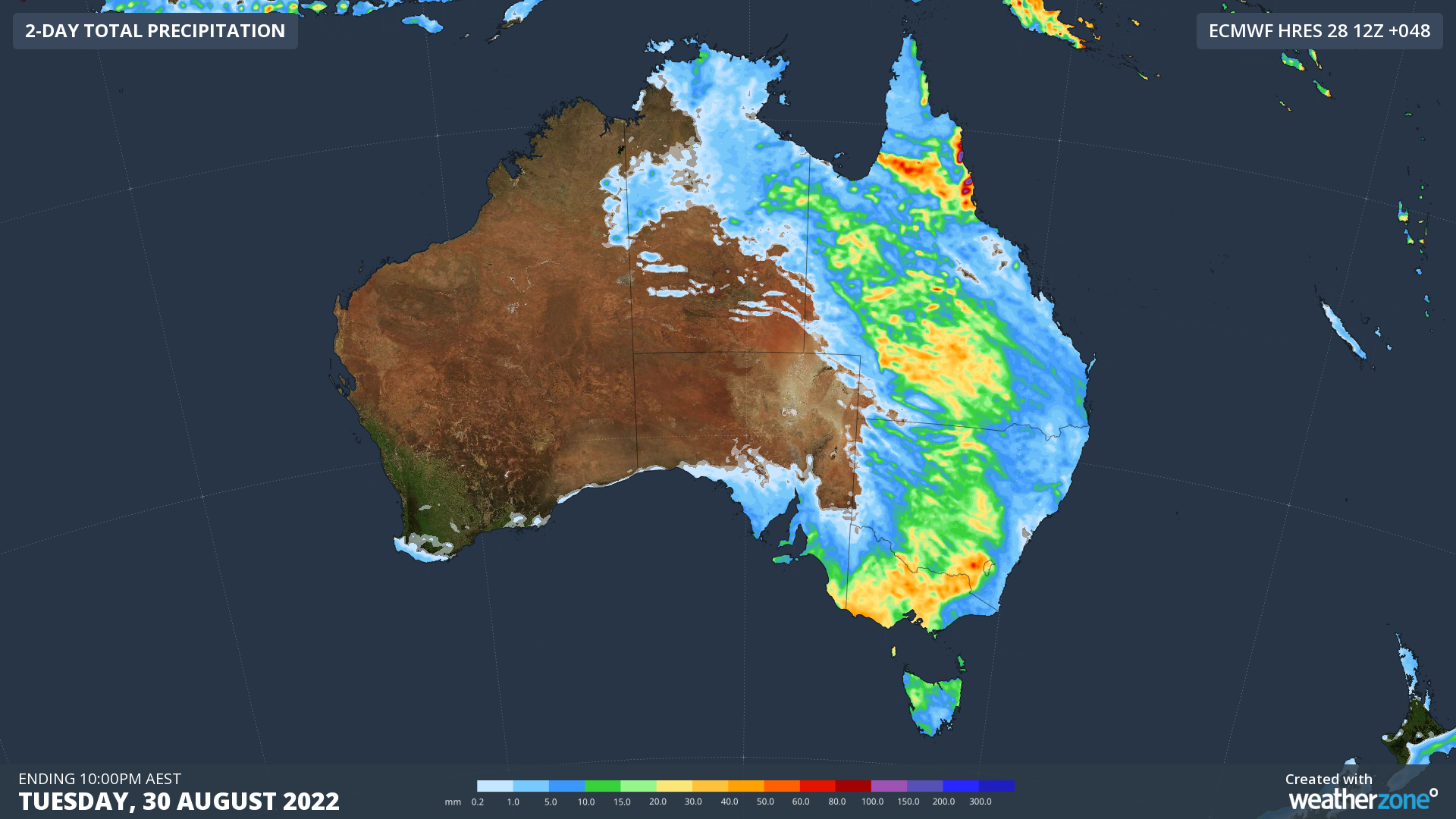
Image: Forecast accumulated rain during the 48 hours ending at 10pm AEST on Tuesday, August 30, showing the areas that are likely to receive rainfall from this system.
Severe thunderstorm warnings will be issued and updated as storms develop over the next 12 to 24 hours.
Weatherzone and DTN have the solution.
Weatherzone can help utilities transform their emergency management practices to proactively plan response and restoration efforts before severe weather-related outage events. Storm Impact Analytics is a damage and outage incident prediction system, developed by Weatherzone’s parent company DTN, that uses a machine learning-based approach to provide a set of quantitative predictions that support a more prepared response.
The outage prediction model considers high winds, temperature, precipitation, atmospheric instability, and more to determine the strength of incoming storms and the associated risks at various time horizons. This weather modelling is combined with non-weather data – such as historic utility outages, utility asset records, vegetation and other variables – and finally machine learning predictive analytics to determine the impact of weather on the utility across specific geographical regions.
This is then translated into impact information, such as the potential number of incidents, customer outages, and restoration effort estimates. This enables utilities to plan, make decisions and deploy restoration crews to the risk area/s, ensuring minimal service disruptions.
How can this system assist utility emergency preparedness managers?
The Storm Impact Analytics solution has been developed to respond to some of the most common questions that utility emergency preparedness managers are facing when extreme weather is on the horizon:
- Which assets are at risk?
- What might be the extent of damage of the assets at risk?
- Which customers could be potentially affected by the forecasted severe weather?
- Which past events are most like this forecasted storm?
- How to plan better for the workforce and inventory of materials that will be critical for restoration efforts?
Improving your outage response strategy and preparing for storms can help reduce your cost recovery.
The Multi-Hazard Mitigation Council estimates that every dollar spent reducing risk before an event such as a flood, or extreme winds, storm surge, wind extreme or wildfire saves up to 10 dollars that would otherwise need to be spent on recovery and response.
The system also enables emergency preparedness managers and their companies to have additional insight into infrastructure resiliency.
Storm Impact Analytics and its machine-learning models are integrated with the Weatherzone platform and include real-time monitoring by local, expert meteorologists, making it far more sophisticated than other methods.
For more information on our Storm Impact Analytics system, please contact us at apac.sales@dtn.com.


