While southeastern states are basking in spring warmth today, a surge of unseasonably cold air is approaching from Antartica with temperatures set to plummet over several states and territories.
The huge temperature contrast over just a day that we will see this week is being caused by a low-pressure system and associated cold front marching through the Southern Ocean on Tuesday. This front is also linking up with tropical cloud and moisture originated from the Indian Ocean with broad areas of rain to prevent daytime heating in the next few days.
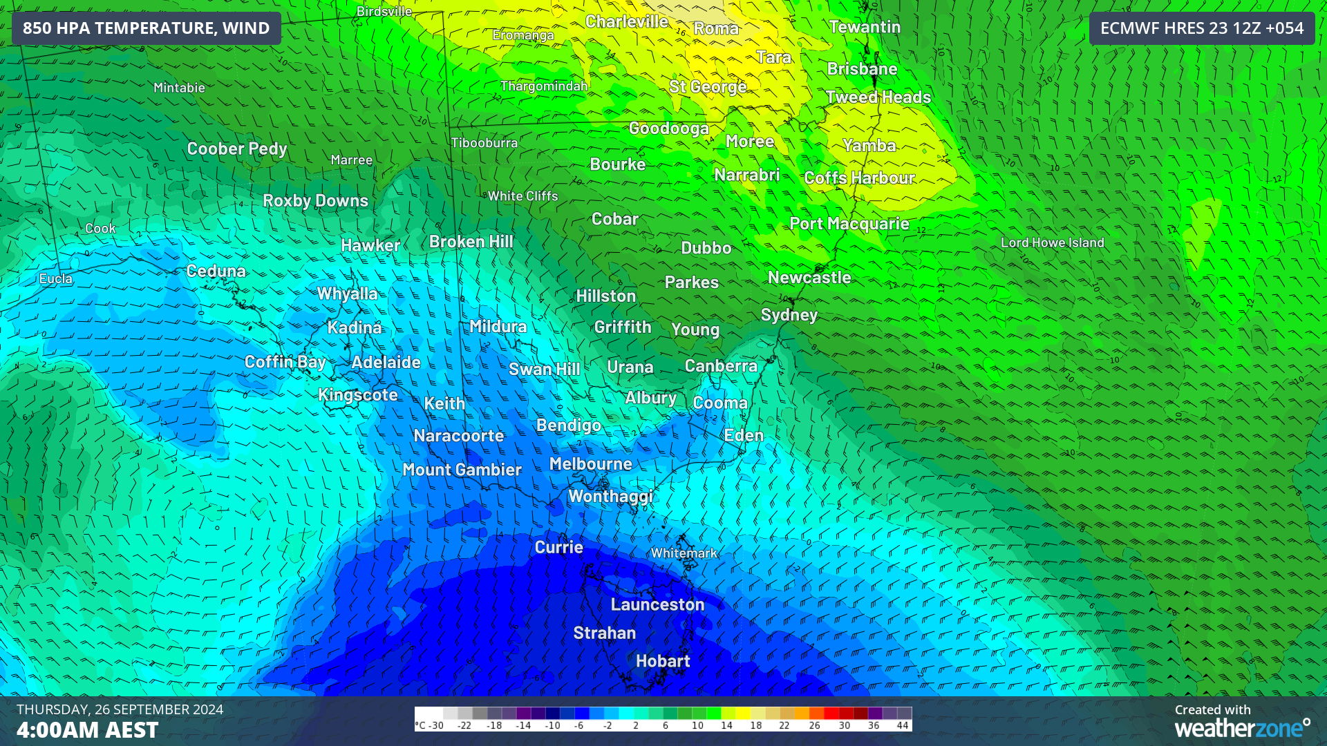
The image below shows the huge disparity in airmasses with warm northwesterly winds ahead of the cold front and icy cold southerly winds behind it.
Image: 850 hPa temperature and wind at 4am on Thursday, September 26, according to ECMWF.
Temperatures will be around 4 to 9°C above average ahead of this system and around 3 to 7° below average behind it.
The maps below show the above average temperatures forecast in the first third of the week, compared to the below average temperatures in the second third.
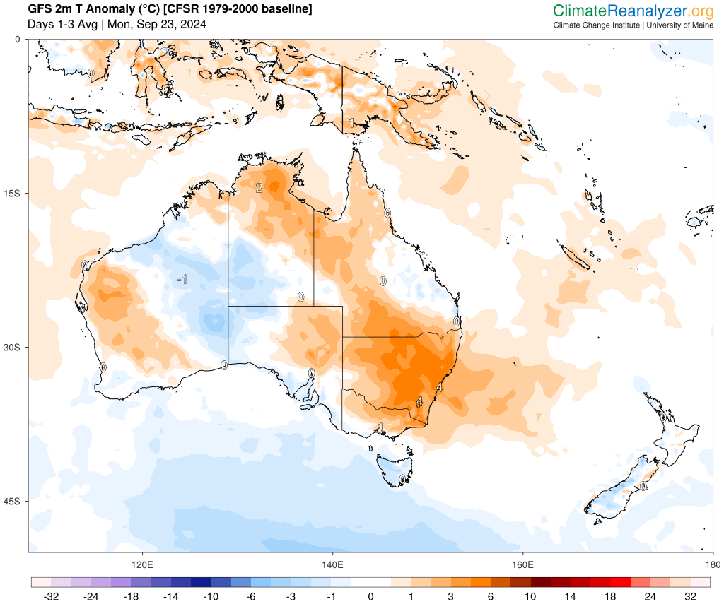
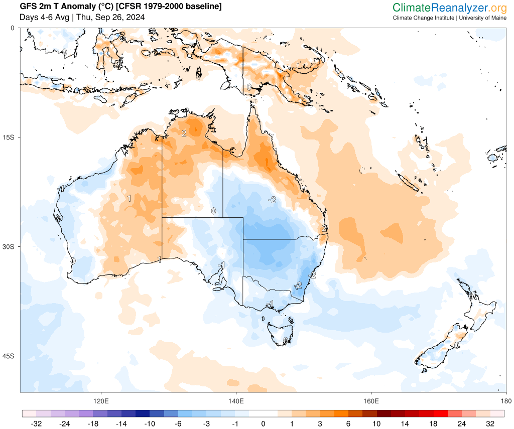
Images: 2m temperature anomaly (°C) forecast for three days beginning Monday September 23 (top) and Thursday, September 26 (bottom), according to GFS. Source: ClimateReanalyzer.org
Several capital cities will feel this 4 to 13 °C maximum temperature shift in the coming days:
- Melbourne’s daytime temperature should drop around 8°C, with 23°C forecast Tuesday and 15°C on Wednesday.
- Sydney’s temperature is forecast to drop around 12°C, with 31°C forecast on Wednesday, plummeting to around 19 to 20°C on Thursday and Friday.
- Adelaide’s temperature will drop from 22°C to 18°C on Thursday, a 4°C drop.
- Hobart’s temperature will also drop around 4°C between today and Thursday.
- Canberra’s temperature is expected to drop around 8°C between Tuesday and Thursday.
- Brisbane’s temperature should reach 29°C on Thursday and drop to around 22- 23°C on Friday
Blusterous southerly winds will also make these temperatures feel around 3 to 5°C colder than the actual temperature.
Behind the cold front and associated frigid airmass, a high pressure system will quickly move into its wake clearing skies and allowing temperatures to drop overnight.
Melbourne, Adelaide and Hobart are likely to see nighttime temperatures drop to around 3 to 5°C below average between Thursday and Saturday mornings.
Both Adelaide and Melbourne’s temperature should drop to around 5 to 6°C for several nights during this period, while Hobart’s minimums will drop to around 3 to 5°C.
After some very cold days and nights, temperatures should warm in the southeastern states over the weekend into early next week ahead of another cold front that will sweep across the region.
Weatherzone Business has grown to become the outright leader within the Australian energy market, serving wind, solar, hydro, trading, utilities and network companies.
You can’t control the weather, but you can gain precision insights to optimise your response. What lights us up is providing your energy business with tailored weather information to reduce your risk and keep you moving ahead of the curve.
Our services cover all aspects – from wind and solar generation to demand forecasts, wholesale markets to retail so, no matter where your company sits, we have solutions for you. We have worked closely with market participants to create products that meet the evolving needs of the sector, aiming to increase safety and profitability for our customers.
Benefit from the timely delivery of accurate weather information, allowing informed and effective decision-making. For more information, please visit our website or email us at apac.sales@dtn.com.


