
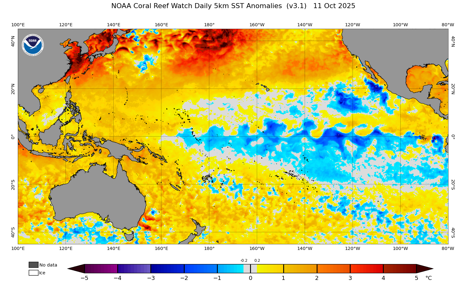
A La Niña advisory has been issued by the US Climate Prediction Center (CPC), indicating that La Niña conditions have emerged in the tropical Pacific Ocean and are expected to continue for the coming months.
What is La Niña?
La Niña is one of three phases of the El Niño-Southern Oscillation (ENSO), a coupled ocean-atmosphere phenomenon that occurs in the tropical Pacific Ocean. The three phases of ENSO are La Niña, El Niño and neutral.
When La Niña is occurring, cooler-than average water sits near the surface of the central and eastern equatorial Pacific Ocean, while easterly trade winds flowing over the tropical Pacific Ocean become stronger than usual. This pattern typically results is in enhanced cloud and rainfall over the western tropical Pacific region, including parts of Australia, Indonesia and southwest Pacific island nations.
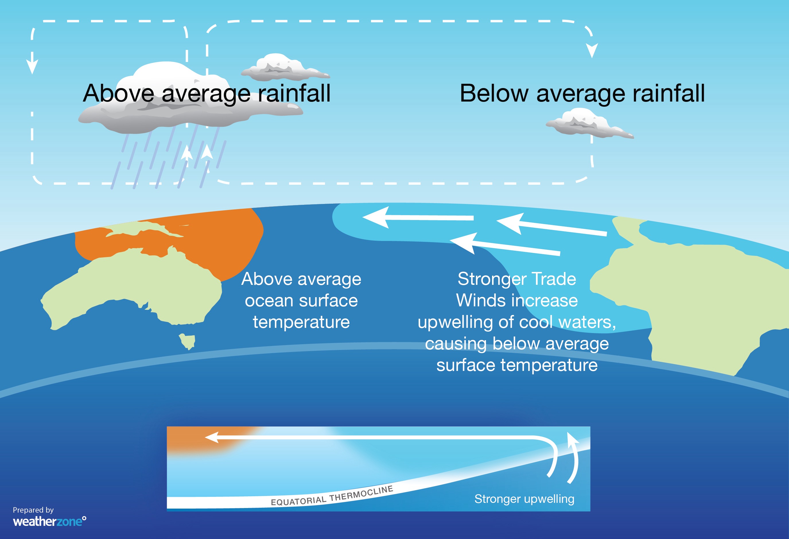
Image: Typical ocean and atmospheric components of La Niña.
La Niña Advisory declared by US Climate Prediction Center
A La Niña advisory was issued late last week by the US Climate Prediction Center (CPC). The advisory stated that “La Niña conditions are present and favored to persist through December 2025 – February 2026, with a transition to ENSO-neutral likely in January-March 2026.”
The CPC’s La Niña definition is based on sea surface temperatures in the central equatorial Pacific Ocean being at least 0.5°C cooler than average, and an expectation that this region will remain below this threshold for at least three consecutive months.
In addition to this ocean component, there also needs to be clear signs of an atmospheric response above the tropical Pacific Ocean for La Niña to be declared by the CPC. According to the advisory, these atmospheric changes are currently being observed.
“Collectively, the coupled ocean-atmosphere system reflected La Niña conditions,” the CPC says.
La Niña not yet recognised by BoM
The CPC’s definition of La Niña differs from that of Australia’s Bureau of Meteorology (BOM). While the CPC has declared that La Niña is underway, the BoM does not agree and still classifies the ENSO as being in a neutral state.
The Bureau has slightly different La Niña thresholds to the CPC, requiring more intense and prolonged ocean cooling in the tropical Pacific Ocean before a La Niña can be declared. Therefore, while conditions have now met the CPC thresholds for declaring La Niña, they aren’t yet sufficient for the BoM to follow suit.
According to the Bureau of Meteorology, “the El Niño–Southern Oscillation (ENSO) remains neutral.”
“The Bureau’s model currently predicts the tropical Pacific is likely to meet La Niña levels briefly during spring, before returning to neutral by summer.”
The current La Niña signal in the Pacific Ocean may not be strong enough for long enough for the BoM to declare La Niña. If one is declared, it is likely to be weak and short-lived.
How will this impact Australia’s weather?
Moderate-to-strong La Niña events that occur during late spring and early summer typically enhance cloud cover, rainfall and suppress daytime temperatures over large areas of Australia, particularly northern, central and eastern parts of the country. However, the influence of weak or borderline La Niña episodes is less predictable.
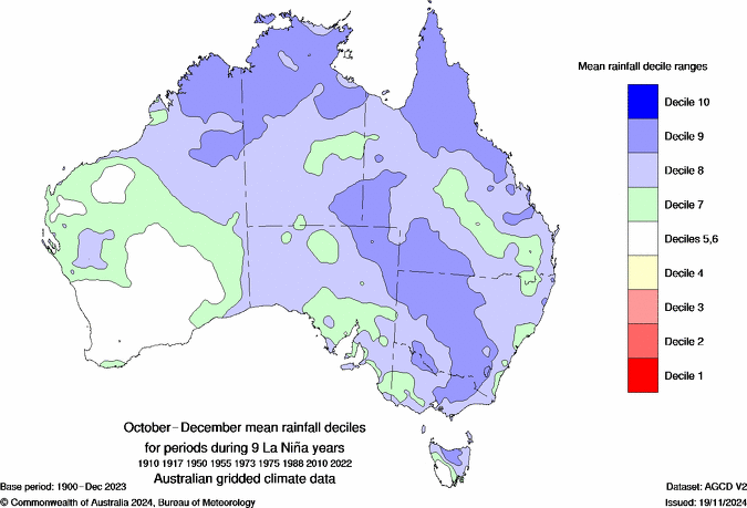
Image: Average October-to-December rainfall during nine moderate to strong La Niña events. Source: Bureau of Meteorology
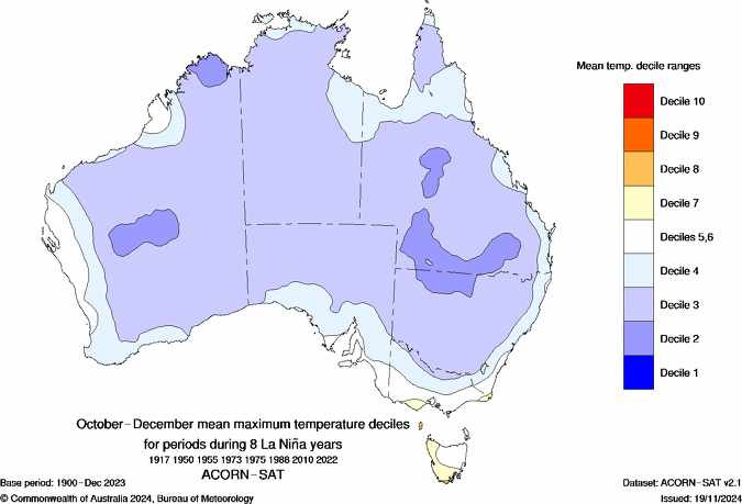
Image: Average October-to-December maximum temperatures during nine moderate to strong La Niña events. Source: Bureau of Meteorology
It is clear that a La Niña-like pattern has become established in the Pacific Ocean in recent weeks. However, this pattern is currently expected to be short-lived and relatively weak, which means it may not have a strong influence on Australia’s weather in the coming months.
Other climate drivers, including the Indian Ocean Dipole (IOD) and Southern Annular Mode (SAM), and abnormally warm sea surface temperatures closer to Australia, are expected to have a stronger influence on the Australian climate over the next few months.
How DTN APAC can help
The shifting climate is bringing increased complexity and greater risks to businesses worldwide. We are here for you, delivering trusted weather solutions to optimize your operations and profitability.
DTN APAC is a diverse team, with global forecasting, product development and analytics expertise. Couple this with extensive industry experience spanning Aviation to Energy, and we are primed to assist you in strengthening your response to weather impact.
We work hard to identify your operational pressures and tailor our services and products to meet your needs. Concise communication, giving you full situational awareness exactly when you need it, is our focus. We want to reduce weather risk in your operations, every day.
We deliver clear and comprehensive weather data that you can’t get anywhere else, personalised risk assessments and briefings to you and your team, so that your critical decisions can be made with confidence.
We are available 365 days a year, so you always have the timely guidance you require, especially when severe conditions hit.
You have our insights to rely on to see you through complex situations, minimising potential loss of profit and maximising the safety of your staff and assets.
Learn more about our large range of industry leading products and services or email us at sales.apac@dtn.com




