It was only last year that we came out of a 3-year La Niña but there is a significant chance that the Pacific Ocean returns to a La Niña state by spring this year, increasing the chances of wet weather across eastern Australia in spring and summer. The 2010/2011 La Niña event demonstrates that such a short turnaround can happen, and computer models have been consistently predicting La Niña as more likely than either El Niño or neutral conditions.
Firstly, it appears that La Niña is currently the more common phase of the El Niño Southern Oscillation (ENSO). We can see that by looking at the multi-variate ENSO index (MEI) for the past several decades from 1979 to 2023. The MEI considers atmospheric variables (cloud, pressure and wind patterns), in addition to the Pacific Ocean’s surface temperature pattern, giving a more wholistic index than other indices.
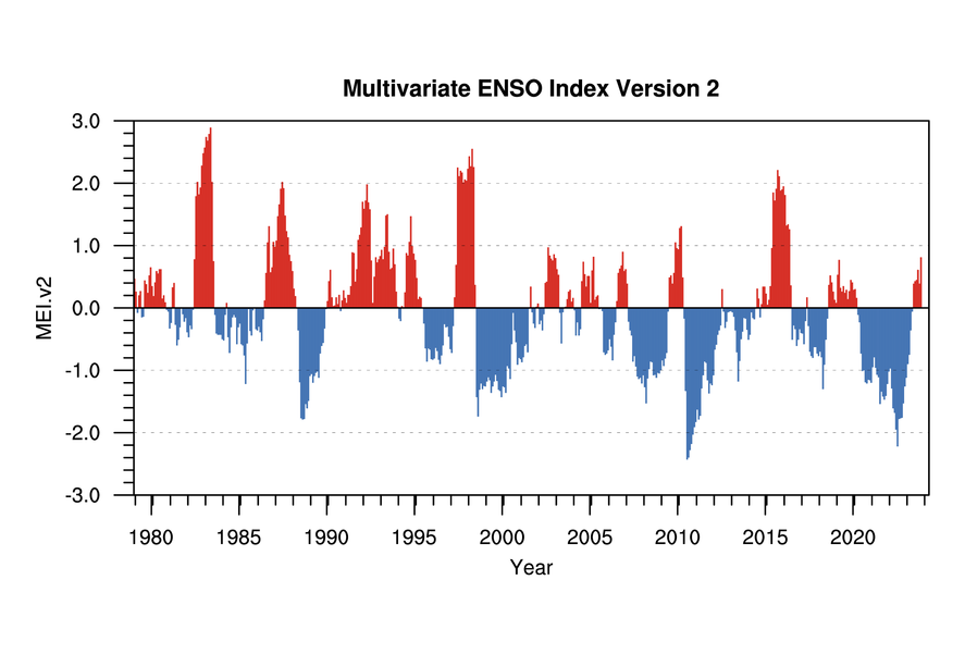
Image: Multivariate ENSO index from 1979 to 2023. Source: NOAA
The graph shows MEI values averaged over two-month periods. El Niños are among the red peaks, La Niñas are among the blue troughs, and neutral conditions are among either colour but with lower values. Up until the 1997/1998 El Niño there was more often El Niño conditions (red peaks) and less often La Niña conditions (blue troughs), but from then onwards there has been more often La Niña conditions and less often El Niño conditions. (This pattern is connected to a longer-term climate oscillation and should reverse back to more El Niños in the future.)
Notice that this year’s El Niño event corresponds only to a small red peak. Even though the oceanic component of El Niño has been quite strong this year, according to the composite MEI value, this year’s El Niño has been rather weak overall due to the atmosphere not linking up strongly with the ocean. In fact, the Southern Oscillation Index (SOI) that measures the pressure pattern associated with ENSO has been above -7 since December 2023, so technically the atmosphere is not currently coupled with the ocean.
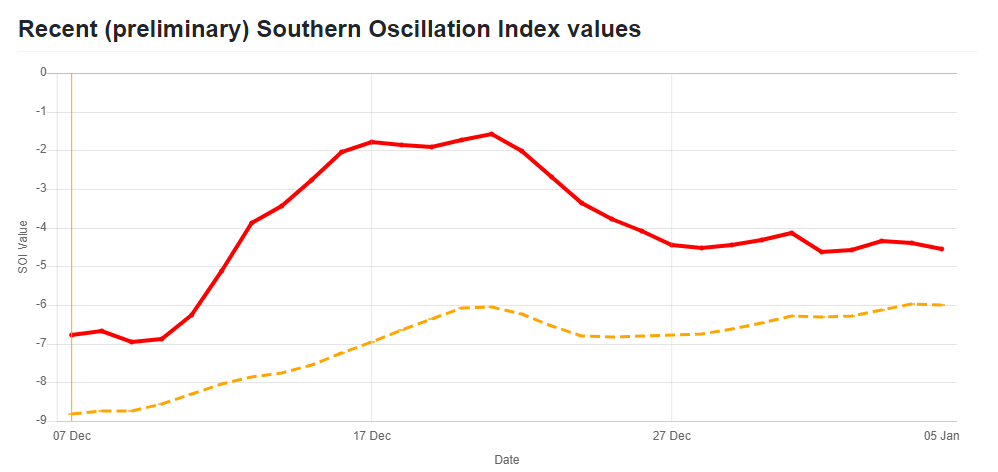
Image: Recent SOI values (red 30 day average, orange 90 day average). Source: longpaddock.qld.gov.au
Now we turn to a recent example of the Pacific Ocean returning quickly to La Niña conditions after a brief El Niño. There were weak-to-moderate La Niña conditions from 2007 to 2009, then there was an El Niño in 2009/2010 that broke down quickly and returned to a very strong La Niña in 2010/2011, leading to Australia’s first and second wettest years (2022 was only the ninth wettest year). So, it would not be surprising if we see La Niña conditions return this year.
Interestingly, the 2009/2010 El Niño contributed to a dry winter and spring but then, despite the El Niño, much of eastern and central Australia experienced an unusually wet summer.
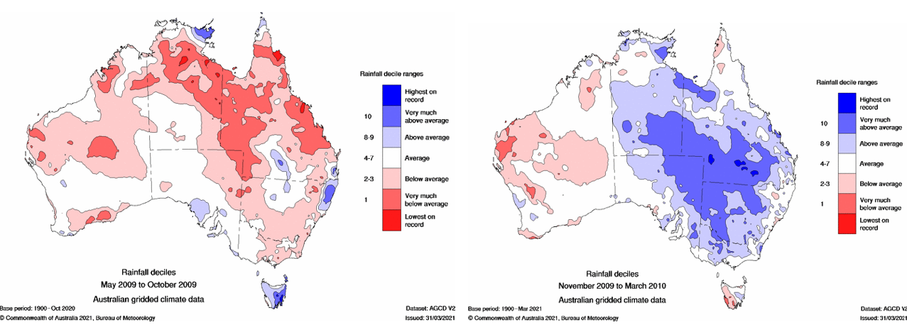
Left: Rainfall deciles May 2009 to October 2009. Right: Rainfall deciles November 2009 to March 2010. Source: BOM
Let’s look at the sea surface temperature patterns over the last few months. Between September 2023 and December 2023 there has been cooling of the eastern Pacific Ocean:
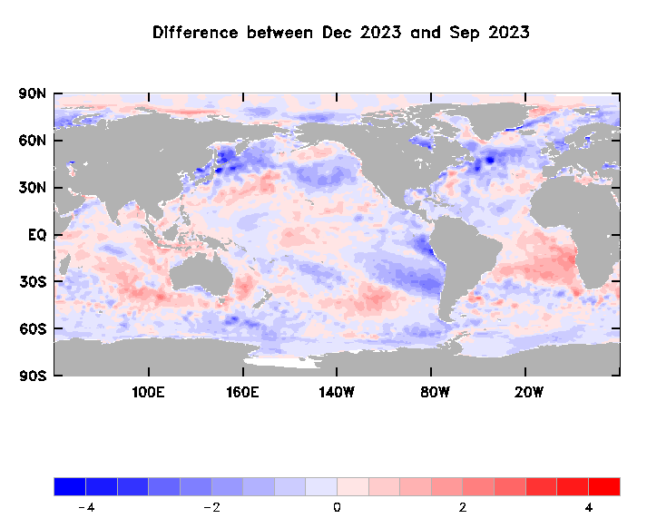
Image: Sea surface temperature difference between December 2023 and September 2023. Source: BOM
In terms of the forecast sea surface temperature pattern, the Canadian and US models are predicting this trend to continue and develop into a La Niña by spring – the blue tongue of colder water along the equatorial Pacific Ocean in the following graphs would constitute a La Niña.
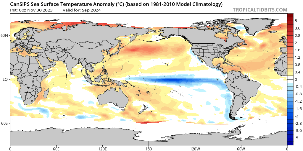
Image: Canadian model (CanSIPS) sea surface temperature anomaly for September 2024. Source: tropicaltidbits.com
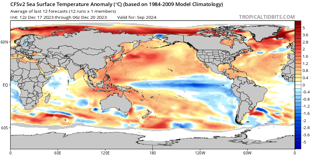
Image: US model (CFS) sea surface temperature anomaly for September 2024. Source: tropicaltidbits.com
The European model does not have a forecast out to spring at this stage, but the forecast to July 2024 indicates the emergence of colder-than-normal water in the eastern Pacific, supporting the other models that go further out in time.
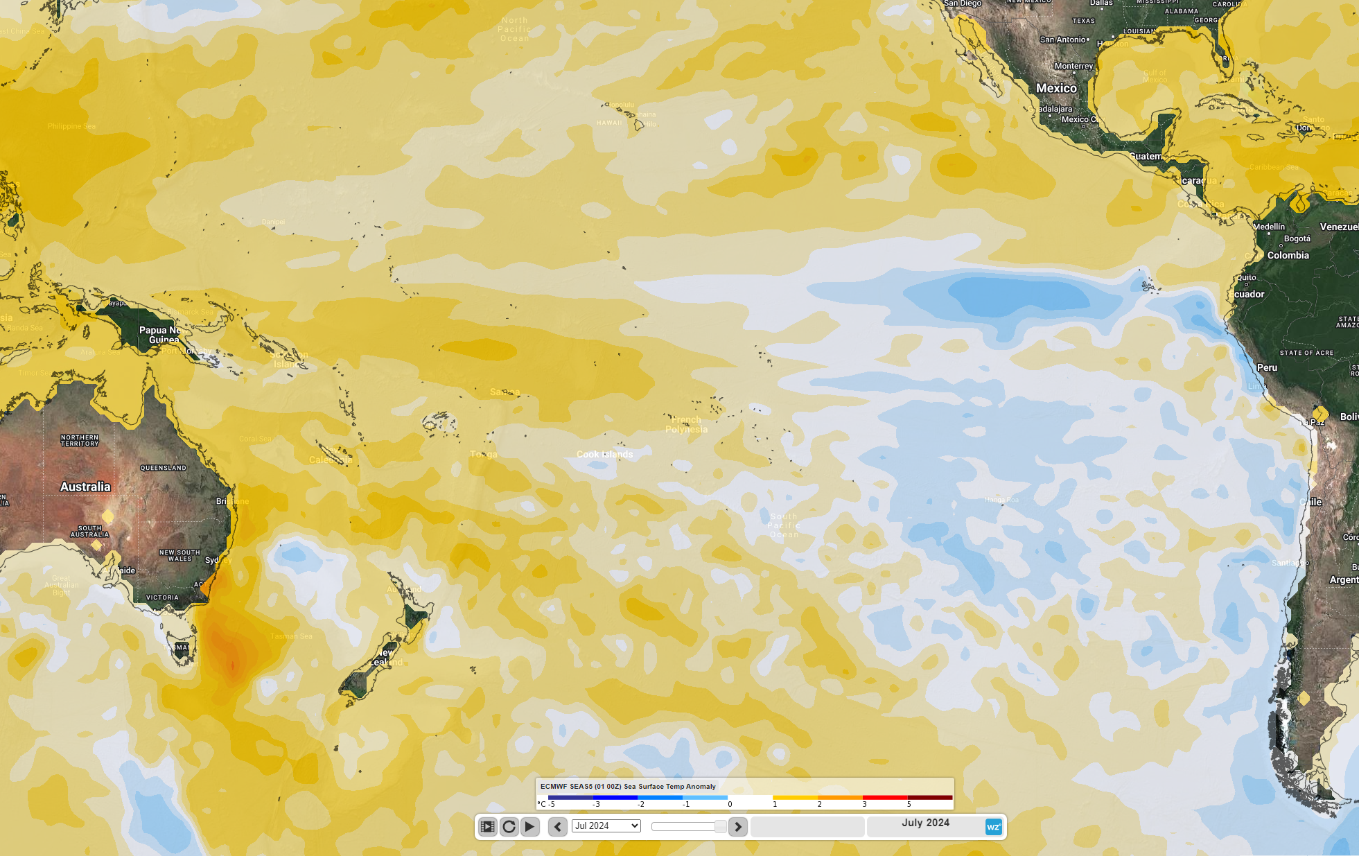
Image: European model (ECMWF) seasonal forecast of sea surface temperature anomalies for July 2024
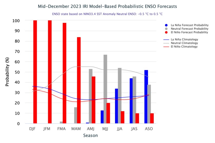
Finally, the probabilistic forecast from the International Research Institute for Climate and Society, is giving a higher chance of La Niña conditions than either El Niño or neutral conditions for the three-month period August-September-October.
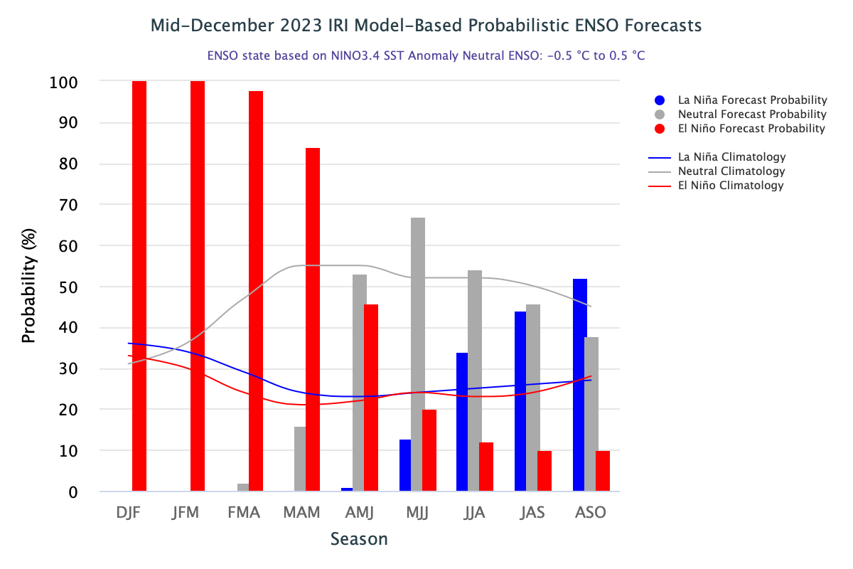
IRI Model-based probabilistic ENSO forecasts published December 19th 2023. Source: iri.columbia.edu
If La Niña does return, then it would increase the chances of a wet spring and summer this year in eastern Australia. It would be just one piece of the puzzle for our weather later this year into next year and there will be other factors like the Indian Ocean Dipole that influence our rainfall and temperature, but it is still an important piece of that puzzle.
For more information on our seasonal climate outlook briefings and updates, please contact us at apac.sales@dtn.com.


