
The data is in, and Australia just registered its warmest financial year on record with a mean temperature more than 1.5°C above the long-term average.
It may seem odd to measure the climate of Australia’s fiscal year, but there are benefits to compiling climate summaries for the 12-month period from July to June.
Firstly, the July-to-June period contains one whole summer (and severe weather season) in Australia. This can make it a good alternative to using calendar years for annual climate summaries, which split summers but contain whole winters.
Secondly, financial year climate summaries can be aligned with other reporting processes that occur over the July-to-June period. This makes it easier for researchers and analysts to compare climate information with other datasets over the same period.
A financial year like no other
Based on temperature observations collected from 112 weather stations across the country, Australia’s national mean temperature in the 2024-25 financial year was 1.68°C above the 1961-90 average. This made it Australia’s warmest financial year in records dating back to 1910, beating the previous record from 2015-16 by 0.28°C.
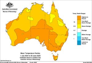
Image: Mean temperature deciles for the 2024-25 financial year. Source: Bureau of Meteorology.
In addition to record-breaking air temperatures, it was also the warmest financial year on record for the oceans surrounding Australia.
The average sea surface temperature in the Australian region during the 2024-25 financial year was 0.94°C above the 1961-90 average. This beat the previous record anomaly of +0.73°C from 2023-24.
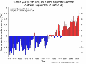
Image: Financial year sea surface temperature anomalies for the Australian region between 1900 and 2025. Source: Bureau of Meteorology.
The 2024-25 financial year was also slightly wetter than usual for Australia, although not as wet as the previous two financial years.
How can DTN APAC help your business this next financial year?
From Mining to Aviation, Transport to Forestry, Energy to Agriculture, DTN APAC services businesses across Australia, Asia Pacific and globally. You can strengthen your business’ response to short- and long-term severe weather impact when you work with our diverse team, bringing you global forecasting, product development, and analytics expertise.
A tropical cyclone season for the books
As seen in our Northern Australia’s 2024-25 wet-season wrap up, 12 tropical cyclones formed in the Australian region, the most since the 2005-06 season, and eight of them were severe (category 3 or more). Over a billion dollars were lost, mainly due to Cyclones Zelia and Alfred, with huge disruptions to mining, aviation and energy industries as shut down procedures had to be taken.
DTN APAC gives you a comprehensive tropical cyclone service that helps your enterprise prepare for the worst in the best possible way.
As the climate delivers increasingly severe weather events, their potential to impact your business operations grows.
DTN APAC, specialises in industry-leading forecast, alerting and threat analysis of tropical cyclones, offering you expert, customised solutions when the weather turns wild.
Providing rapid-update forecast information, we alert you to any low-pressure system gaining power within your region and, unlike other providers, can track its development out to 7 days. This gives you the time to prepare and safeguard your staff, sites and assets.
You will have the most precise weather intelligence charting rainfall, wind speeds and potential storm surges to help you make critical decisions quickly. Whether it’s adjusting key work schedules, protecting your staff or securing your site, we have the alerting capability to keep you steps ahead of the storm.
We will support you, 24/7, keeping you informed and making your critical decisions easier.
Intense drought conditions spread across more than just the agricultural sector
The wetter than usual conditions around Australia were unfairly spread, with most of that rain falling across northern and eastern parts of the country. The hot and dry conditions exacerbated intense drought conditions across parts of western and southern Australia, with a record dry start to the year for South Australia, Victoria and Tasmania.
Dry weather also impacts forestry, emergency services and the mining industry through unseasonable fire risk across Australia’s south during winter and increased risk of dust from blasting dispersing, leading to costly environmental fines.
DTN APAC offers seasonal and long-term outlooks covering wind, rainfall and extreme heat out to 12 months into the future. The shifting climate is bringing increased complexity and greater risks to businesses worldwide. We are here for you, delivering trusted weather solutions to optimize your operations and profitability.
Our Weather Risk Communicators work hard to identify your operational pressures and tailor services and products to meet your needs. Concise communication, giving you full situational awareness exactly when you need it, is our focus. We want to reduce weather risk in your operations, every day.
We deliver clear and comprehensive weather data that you can’t get anywhere else, personalised risk assessments and briefings to you and your team, so that your critical decisions can be made with confidence.
We are available 365 days a year, so you always have the timely guidance you require, especially when severe conditions hit.
You have our insights to rely on to see you through complex situations, minimising potential loss of profit and maximising the safety of your staff and assets.
Learn more about our large range of industry leading products and services or email us at sales.apac@dtn.com
Thumbnail image source: iStock / Siwawut


