

A dangerous mixture of hot, dry and windy weather is causing catastrophic fire danger ratings in parts of western Victoria today. The term ‘catastrophic fire danger’ refers to the highest rating on the Australian Fire Danger Rating System, which has four tiers: Moderate High Extreme Catastrophic Each category corresponds to a range of values in […]

Parts of central and western Victoria have just endured their driest February in more than 30 years, priming the landscape for extreme to catastrophic fire danger this Wednesday. While December and January were abnormally wet for most of Vic, the tap has been turned off for the western half of the state during February. The […]
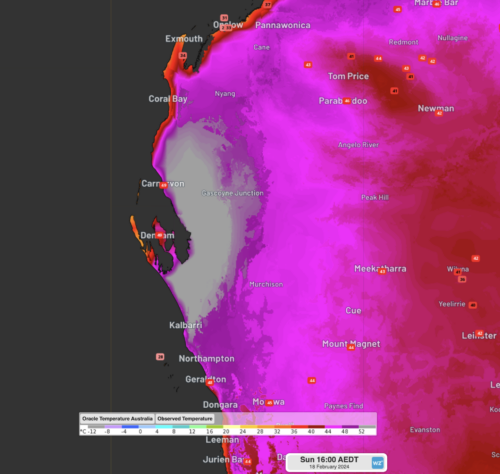
Temperatures reached close to 50 degrees over parts of WA’s Gascoyne and Central West, setting new town records over the region, and ranking in some of Australia’s hottest temperatures ever recorded. The Gascoyne region of Western Australia spans over 135,000 square kilometres (about double that of Tasmania), yet only has a total of 6 weather […]
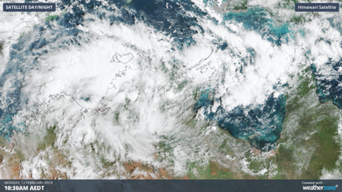
Darwin has had its wettest day in 7 years as a tropical low builds strength in the Top End and could become a tropical cyclone later this week. Over the last 36 hours, a tropical low has been building over the western Top End. Last night, the low strengthened enough to incorporate cross-equatorial winds from […]

Australia just had its third-warmest and ninth-wettest January on record, which is a remarkable combination. Ordinarily, you would not expect both above-average temperatures and above-average rainfall to go hand in hand. Simply put, that’s because clouds block direct sunlight, preventing warming. For example, Australia’s hottest January on record fell in a scorching, sunny summer. That […]
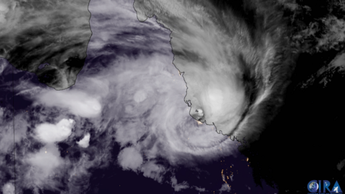
Some weather models are hinting at the possibility of yet another tropical cyclone, after Jasper and Kirrily, to develop in the Coral Sea and make landfall over the Queensland coast. But how likely is this to happen at this stage? Thumbnail image: Severe Tropical Cyclone Kirrily at landfall. Source: Cooperative Institute for Research in the Atmosphere […]

Was it really only yesterday that we were wondering where summer had gone in Melbourne? On Monday morning, we published a story about Melbourne’s relatively mild summer of 2023/2034 to date, in which we noted that: Average Melbourne maximums had been around half a degree below the long-term average in both December and January, although […]
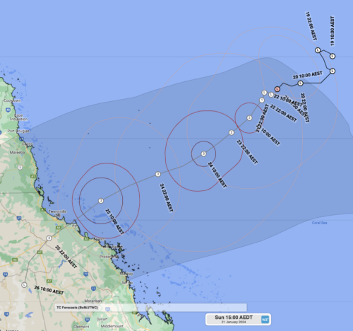
A tropical low, soon to be named Tropical Cyclone Kirrily, is expected to make landfall over Queensland this week as a category 3 strength system. At 11am AEST Sunday, Tropical Low 05U was about 940 km east northeast of Townsville, with wind gusts up to 85km/h and was slow-moving. This large mass of swirling cloud […]

Weatherzone and DTN both honour the accomplishments and prioritise the professional development of our dedicated team. In a world that continually accelerates with advancements across the science and tech space, our responsibility and passion is to stay at the forefront. Our experts are always broadening their innovative capacity, and undergoing continuous education in response to […]

Australia’s tropical cyclone season is officially underway, but we may not see much activity for few months yet. The season runs from November to April, and for mining operators and businesses across northern Australia, 2026-27 is shaping up to be a season where the headline numbers and the real risk may not line up. On […]

A positive Indian Ocean Dipole is underway, but this one is unlikely to deliver the textbook dry spring and summer that businesses have come to expect from the pattern. The Bureau of Meteorology officially declared a positive IOD on Tuesday, October 27, which typically like El Niño can cause drier and warmer conditions over parts of […]

Waters off Indonesia have cooled in recent weeks, an indication that a positive Indian Ocean Dipole (IOD) event could be developing. It’s an important climate driver for Australia, and it could shape rainfall and temperatures heading into summer, with flow-on effects for farmers, energy and other industries. What is the Indian Ocean Dipole? The IOD […]

Leonora, WA, had its wettest September day on record earlier this month. Three weeks later, more than 1.3 million lightning pulses were detected within 800 km of the town in 48 hours. Why is a stalled trough delivering storms to mining country, and what it could mean for operations? The DTN Total Lightning Network detected […]
