Prosper in a dynamic world
Search

Australia has never seen a January like it

Australia just had its third-warmest and ninth-wettest January on record, which is a remarkable combination.

Ordinarily, you would not expect both above-average temperatures and above-average rainfall to go hand in hand. Simply put, that’s because clouds block direct sunlight, preventing warming.

For example, Australia’s hottest January on record fell in a scorching, sunny summer. That was January 2019, when rainfall was significantly below average in all states and territories.

But in January 2024:

• Australia’s national area-averaged mean temperature was 1.54°C above the 1961–1990 average

     • Australia’s area-averaged rainfall total in January was 47.4% above the 1961–1990 average

It’s interesting to note that rainfall and temperatures in January 2024 were not only above average across Australia as a whole, but in all eight states and territories.

That might come as a suprise to residents of Melbourne, where December and January maximum temps were slightly below average as we mentioned in a recent story. https://www.weatherzone.com.au/news/when-will-melbourne-have-real-summer/1766019

But as you can can see on the chart below, Victoria’s mean (overall 24-hour) temps were actually slightly above average due to a combination of extreme heat in the state’s northwest and warmer-than-usual minimums across the whole state.
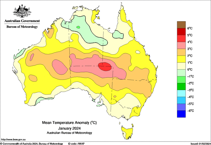
Source: Bom

Just as Melburnians might be surprised by the January temperature data, many West Australians will doubtless be taken aback by the fact it was a wet month nationwide.

If you look at the rainfall chart below, you’ll see that most of the west coast was parched.
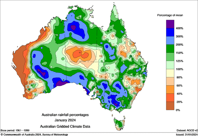
Source: BoM 

There were also other parts of the country that had a dry January compared to normal, including parts of central Queensland that missed the action from ex-Tropical Cyclone Kirrily. https://www.weatherzone.com.au/news/extc-kirrily-just-refuses-to-quit/1771881

But Australia is a large country, and when averaged out as a whole, January 2024 was indeed a remarkable month for both warmth and wetness.

To find out more, please visit our website or email us at apac.sales@dtn.com.

Latest news

Satisfy your weather obsession with these news headlines from around the nation, and the world.

Rapid El Niño signal accelerating risk for Australian businesses

El Niño–favourable conditions are gathering pace across the tropical Pacific, with key ocean indicators approaching threshold levels and early atmospheric responses emerging.  While uncertainty remains around final El Niño strength, historical analogues show that even weak events can generate widespread impacts, including reduced rainfall, warmer daytime temperatures, increased frost risk, elevated fire danger, reduced tropical cyclone activity, and more. Industries including […]

Australia’s 2025–26 Cyclone Season: Slightly Above Average, Dominated by Severe Systems

Australia has just experienced a highly impactful tropical cyclone season, with more than 60% of systems reaching severe intensity, causing widespread disruption and damage to communities and multiple industries across northern Australia.  The 2025–26 Australian tropical cyclone season officially ran from 1 November 2025 to 30 April 2026. During this six-month period, Australia saw 11 tropical cyclones, with nine […]

What does a ‘super El Niño’ mean for Australia’s businesses?

There are signs that a very strong, or ‘super’ El Niño could develop in the tropical Pacific Ocean later this year. So, what does this mean for Australia’s weather during the second half of 2026? El Niño on the horizon The tropical Pacific Ocean is currently in a neutral state, meaning neither El Niño nor […]

How does DTN help businesses monitor bushfire induced pyrocumulonimbus thunderstorms that ignite more fires?

Intense heat from bushfires during elevated fire danger days can trigger fire-induced pyrocumulonimbus thunderstorms that ignite additional fires. In early January 2026, an extreme heatwave sweeping over southeastern Australia brought catastrophic fire danger to Victoria. Intensely hot bush and grass fires spread erratically and quickly in hot, dry and gusty winds, with pyrocumulonimbus generating lightning, […]