
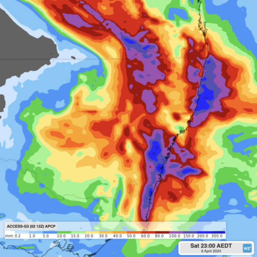
Heavy rainfall of up to 300mm is expected this Friday and Saturday for southeast Queensland and eastern NSW, as a powerful cut-off low and a moisture-rich coastal trough combine. A pool of cold air currently crossing the Great Australian Bight is expected to produce an upper-level low pressure system over southeastern Australia by Thursday. This […]

What a turnaround in Melbourne weather. After the driest March in 170 years of records, Melbourne just had its heaviest day of April rain in 47 years and its wettest day in any month in a tick over four years. Just 2.8 mm was recorded in Melbourne’s gauge at Olympic Park during the whole of […]

The tropical moisture that caused significant flooding in the NT and Qld is set to move southeast over Easter, bringing heavy rainfall, thunderstorms and possible flooding and damaging winds with it. The map below shows the massive rainfall totals that fell across the southern NT and parts of Qld over the last week. Image: The […]
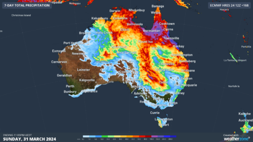
Heavy rain and thunderstorms will continue in parts of Qld and the NT over the next few days, increasing the risk of flooding and outback road closures. This week’s wet weather is being caused by the remnants of Tropical Cyclone Megan and an associated low-pressure trough extending across the NT and Qld. The […]
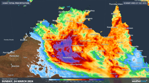
There are early signs that parts of SA, the NT, NSW and Qld could get soaked on the Easter long weekend, as moisture left behind by ex-Tropical Cyclone Megan spreads south. Tropical Cyclone Megan made landfall over the southwest Gulf of Carpentaria on Monday, March 18. The system then weakened to a tropical low […]
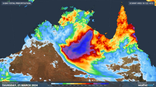
The remnants of Severe Tropical Cyclone Megan will carry heavy rain across the NT over the next few days as communities assess the damage in the powerful system’s wake. Megan made landfall as a category three severe tropical cyclone on Monday afternoon, crossing the coast to the southeast of Port McArthur. The tropical cyclone caused […]
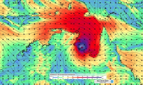
Destructive winds have started to lash the NT coastline as Severe Tropical Cyclone Megan edges closer to making landfall. At 9:30am ACST on Monday, March 18, Severe Tropical Cyclone Megan was a category three system located 55 km east northeast of Port McArthur. The satellite images below show the powerful cyclone sitting over the Gulf […]
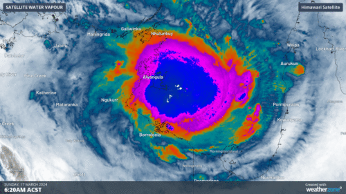
After dumping half a year’s worth of rainfall over Groote Eylandt in the past 48 hours, Tropical Cyclone Megan is building strength in the Gulf of Carpentaria and will make landfall over the NT coast on Monday night. Tropical Cyclone Megan formed on Saturday afternoon in the Gulf of Carpentaria, making it the fifth tropical […]
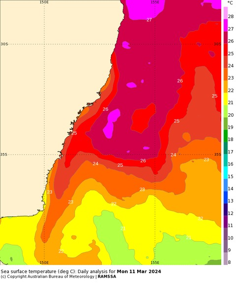
A tongue of water warm enough to support tropical cyclone development has been detected off the central NSW coast this month, breaking temperature records in the western Tasman Sea. Sea surface temperatures off the NSW coast have been running around 2 to 3°C above average in recent weeks, with some areas more than 3°C warmer […]

Australia’s tropical cyclone season is officially underway, but we may not see much activity for few months yet. The season runs from November to April, and for mining operators and businesses across northern Australia, 2026-27 is shaping up to be a season where the headline numbers and the real risk may not line up. On […]

A positive Indian Ocean Dipole is underway, but this one is unlikely to deliver the textbook dry spring and summer that businesses have come to expect from the pattern. The Bureau of Meteorology officially declared a positive IOD on Tuesday, October 27, which typically like El Niño can cause drier and warmer conditions over parts of […]

Waters off Indonesia have cooled in recent weeks, an indication that a positive Indian Ocean Dipole (IOD) event could be developing. It’s an important climate driver for Australia, and it could shape rainfall and temperatures heading into summer, with flow-on effects for farmers, energy and other industries. What is the Indian Ocean Dipole? The IOD […]

Leonora, WA, had its wettest September day on record earlier this month. Three weeks later, more than 1.3 million lightning pulses were detected within 800 km of the town in 48 hours. Why is a stalled trough delivering storms to mining country, and what it could mean for operations? The DTN Total Lightning Network detected […]
