
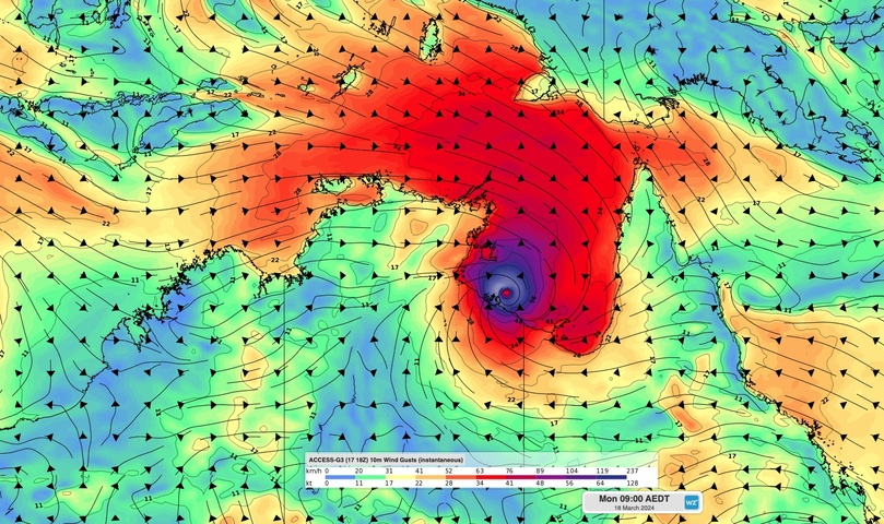
Destructive winds have started to lash the NT coastline as Severe Tropical Cyclone Megan edges closer to making landfall.
At 9:30am ACST on Monday, March 18, Severe Tropical Cyclone Megan was a category three system located 55 km east northeast of Port McArthur. The satellite images below show the powerful cyclone sitting over the Gulf of Carpentaria on Monday morning,
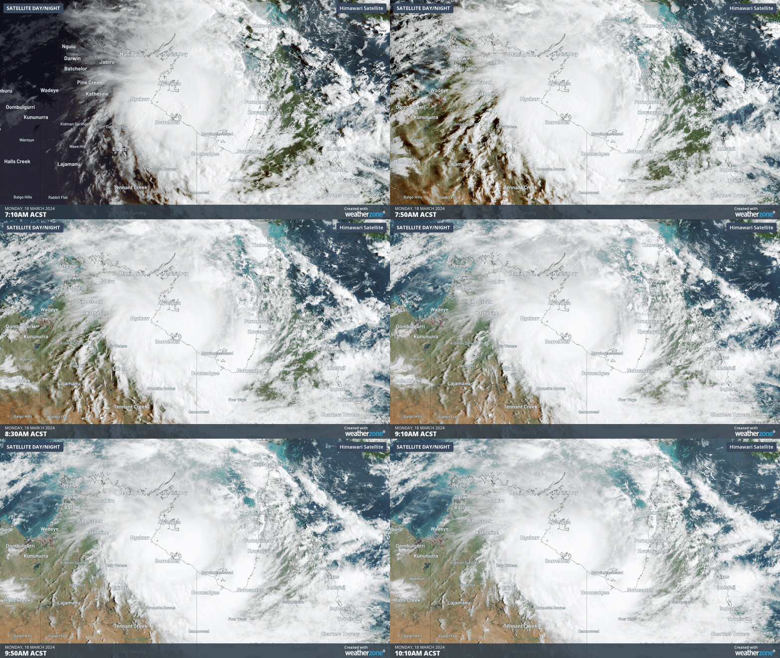
While Megan is not expected to make landfall until Monday afternoon, it was already close enough to the coast to cause severe weather on Monday morning.
A wind gust of 126 km/h was observed at Centre Island shortly before 9am ACST on Monday. Less than one hour later, a gust of 132 km/h was recorded at 9:43am.
Centre Island is part of the Sir Edwards Pellew Group of Islands, which sit just off the NT coast in the southwest Gulf of Carpentaria. These islands are expected feel the full force of Megan as the system approaches the NT coast on Monday.
According to the official forecast track map from the Bureau of Meteorology, severe Tropical Cyclone Megan is expected to make landfall between Bing Bong and the NT/Qld Border during Monday afternoon into the evening.
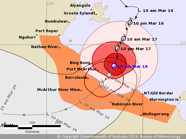
Image: Track map for severe tropical cyclone Megan, issued at 10:21am ACST on Monday, March 18, 2024. A more recent track map may be available. Source: Bureau of Meteorology
Megan’s landfall is likely to cause very destructive winds, heavy rainfall, flooding and a dangerous storm tide over the Sir Edwards Pellew Group and along the southwest coast of the Gulf of Carpentaria.
This may include wind gusts to around 200 km/h near Megan’s very destructive core, and more than 500 mm of rain near and to the east of the system’s centre.
Megan should weaken quickly after crossing the coast. However, the remnant low pressure system is expected to carry heavy rain across the NT during the next few days.
The map below shows how much rain one forecast model is predicting over the NT between Monday and Wednesday.
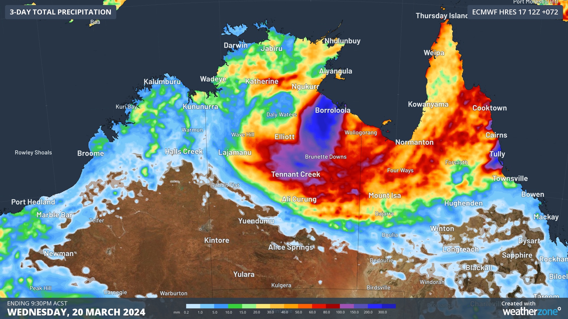
Image: Forecast accumulated rain during the 72 hours ending at 9:30pm ACST on Wednesday, March 20, according to the ECMWF-HRES model.
Megan will be the fourth tropical cyclone to make landfall in the Australian region so far this season and the second to cross the NT coast.
Check the latest tropical cyclone advisories and track maps for the most up-to-date information on Tropical Cyclone Megan.
DTN APAC, specialises in industry-leading forecast, alerting and threat analysis of tropical cyclones, offering you expert, customised solutions when the weather turns wild.
Providing rapid-update forecast information, we alert you to any low-pressure system gaining power within your region and, unlike other providers, can track its development out to 7 days. This gives you the time to prepare and safeguard your staff, sites and assets.
You will have the most precise weather intelligence charting rainfall, wind speeds and potential storm surges to help you make critical decisions quickly. Whether it’s adjusting key work schedules, protecting your staff or securing your site, we have the alerting capability to keep you steps ahead of the storm.
We will support you, 24/7, keeping you informed and making your critical decisions easier. For more information, please contact us at apac.sales@dtn.com.




