

Prosper in a dynamic world
Search

The polar vortex and how it affects Australia

Stretching high above Earth’s North and South Poles are two swirling columns of extremely cold air encircled by powerful winds. These whirlpools of frigid air and wind are each called the polar vortex, and they can have a big...

Winter 2024 outlook

Australia has entered winter without any strong climate drivers influencing the country’s weather patterns. So, what can we expect to see across Australia during winter 2024? The term ‘climate drivers’ refers to patterns of sea surface temperatures and associated...

Damaging wind warning for entire state of Tasmania

A severe weather warning has been issued for damaging winds across all 11 weather districts in Tasmania on Friday, with dangerous gusts also likely in parts of Victoria, NSW and the ACT over the next two days. A strong cold...

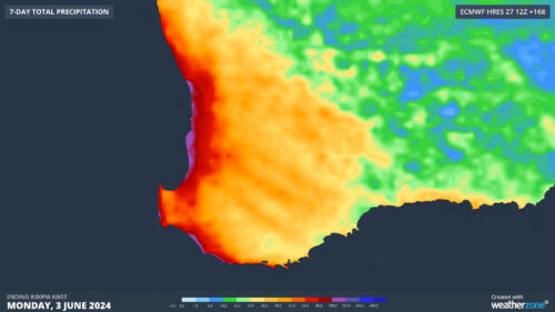
Welcome rain returning to WA this week

A series of cold fronts will deliver much-needed rain to southwestern Australia this week, easing a drought that has broken records over the past seven months. The animation below shows cloud streaming over WA on Tuesday morning ahead of...

Catastrophic fire danger observed in western Victoria

A dangerous mixture of hot, dry and windy weather is causing catastrophic fire danger ratings in parts of western Victoria today. The term ‘catastrophic fire danger’ refers to the highest rating on the Australian Fire Danger Rating System, which...

Driest February in decades to bring catastrophic fire danger in western Victoria

Parts of central and western Victoria have just endured their driest February in more than 30 years, priming the landscape for extreme to catastrophic fire danger this Wednesday. While December and January were abnormally wet for most of Vic,...

Rain and lightning over NSW, Qld fires

A burst of rain and thunderstorms swept over a number of active fire grounds in northern NSW and southern Qld on Friday, delivering a bittersweet mix of welcome rain and pesky lightning. Friday is the first day of a...

Latest news

Satisfy your weather obsession with these news headlines from around the nation, and the world.

Australia’s 2026-27 Tropical Cyclone Season: Late Start, Real Risk

Australia’s tropical cyclone season is officially underway, but we may not see much activity for few months yet.  The season runs from November to April, and for mining operators and businesses across northern Australia, 2026-27 is shaping up to be a season where the headline numbers and the real risk may not line up.  On […]

Positive IOD declared: Not a typical dry signal for Australia

A positive Indian Ocean Dipole is underway, but this one is unlikely to deliver the textbook dry spring and summer that businesses have come to expect from the pattern.  The Bureau of Meteorology officially declared a positive IOD on Tuesday, October 27, which typically like El Niño can cause drier and warmer conditions over parts of […]

Signs of a positive Indian Ocean Dipole, but it may not follow the textbook

Waters off Indonesia have cooled in recent weeks, an indication that a positive Indian Ocean Dipole (IOD) event could be developing. It’s an important climate driver for Australia, and it could shape rainfall and temperatures heading into summer, with flow-on effects for farmers, energy and other industries.  What is the Indian Ocean Dipole?  The IOD […]

1.3 million lightning strikes and a record September downpour: the storms testing WA’s Goldfields

Leonora, WA, had its wettest September day on record earlier this month. Three weeks later, more than 1.3 million lightning pulses were detected within 800 km of the town in 48 hours. Why is a stalled trough delivering storms to mining country, and what it could mean for operations?  The DTN Total Lightning Network detected […]
