Prosper in a dynamic world
Search

WA: wintry chill down south, tropical cyclone up north

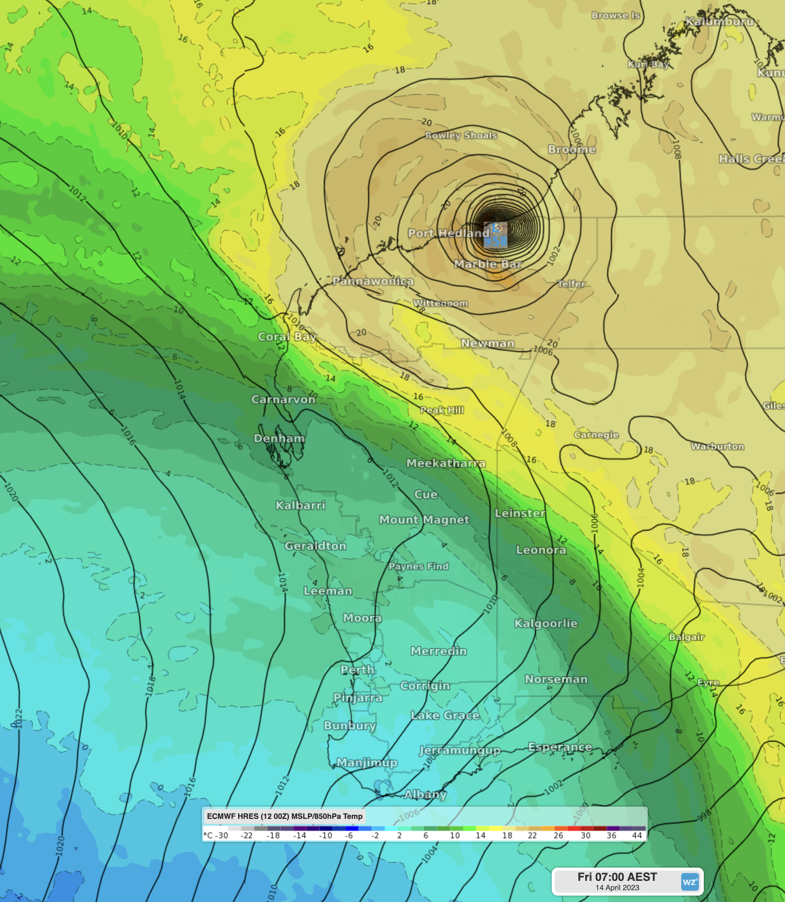
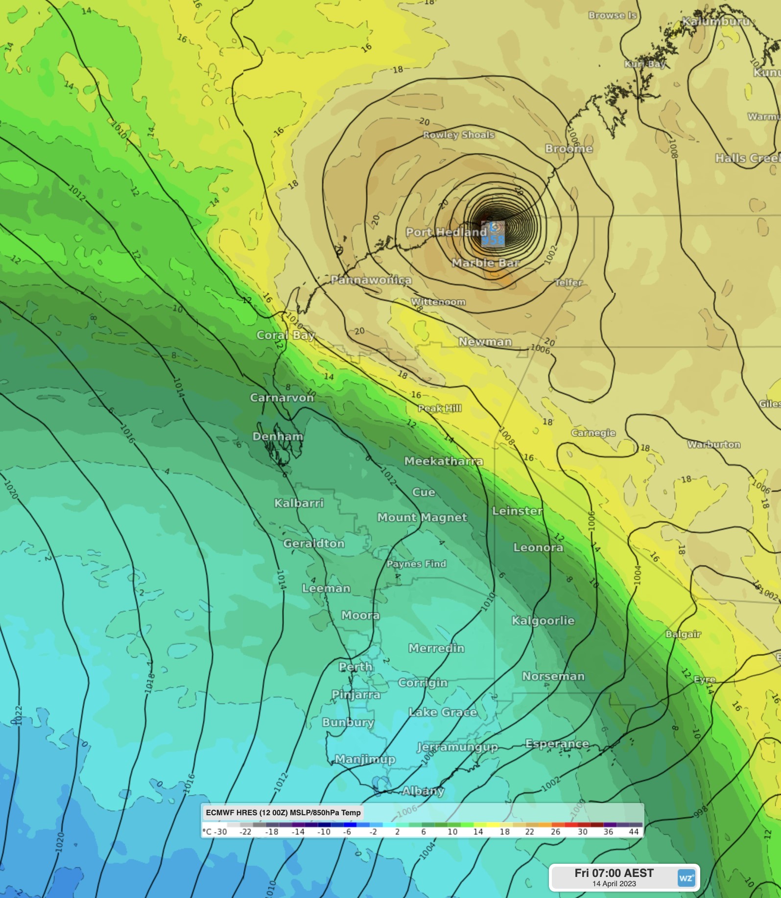
It’s all happening in West Australian weather right now, with Severe Tropical Cyclone Ilsa bearing down on the Kimberley and Pilbara while a strong cold front lurks southwest of Perth as WA sees a wintry chill down south.

We’ve written lots about Ilsa this week and there will be plenty more to cover as it reaches Category 4 strength and crosses the coastline later on Thursday.

For now, let’s focus on the system set to impact WA’s South West Land Division in coming days. You can see the arched cloudband and tell-tale speckle cloud pattern of polar air behind the cold front on the Wednesday afternoon satellite image. You also can’t miss TC Ilsa.

WA: wintry chill down south. tropical cyclone up north

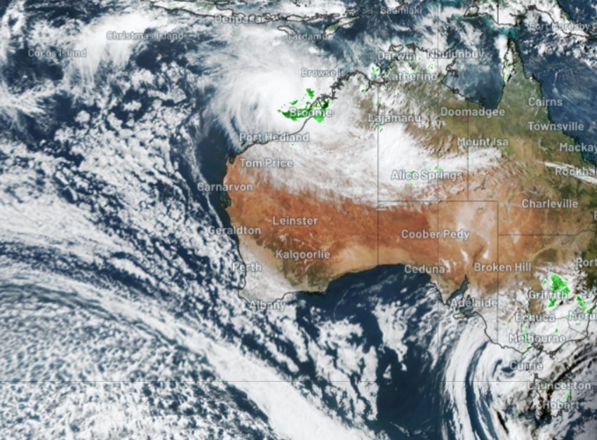
It’s quite the contrast to see two powerful systems like this simultaneously about to impact a single Australian state.

For Perth, the first serious cold front of autumn won’t bring a lot of rain, but it will usher in the first day of 2023 with a maximum below 20°C, with Friday topping out at 18°C or 19°C.

WA: wintry chill down south. tropical cyclone up north

On the south coast, Albany will reach only 15°C on Friday, and plenty of rain can be expected down that way too, along with some small hail.

Indeed, Albany’s average max temp in July (the coldest month) is 15.8°C. So we’re going to see southern parts of WA shiver through temps colder than an average winter day, while a cyclone rages up north.

That says plenty about the time of year, but mostly it speaks to the vastness of the great state of Western Australia.

As ever, please check our warnings page for the latest on Severe Tropical Cyclone Ilsa and any other extreme weather.

To find out about Weatherzones temperature, visit our website or email us at apac.sales@dtn.com.

Latest news

Satisfy your weather obsession with these news headlines from around the nation, and the world.

Madden-Julian Oscillation increasing tropical cyclone potential for northern Australia industries

Sea surface temperatures exceeding 31°C off the coast of northern Australia and an active phase of the Madden-Julian Oscillation (MJO) are increasing the likelihood of early-season tropical cyclone activity, with hints of the season’s first tropical cyclone coming as early as next week. Tropical cyclones require sea surface temperature of 26.5°C or warmer to develop, […]

Tropical cyclone season begins with warm oceans surrounding northern Australia

The 2025-26 tropical cyclone season has begun with abnormally warm oceans surrounding northern Australia, signalling an increased risk for severe tropical cyclones in the coming months. The Australian tropical cyclone season runs from November 1 to April 30. During this six-month period, there are usually about 9 to 10 tropical cyclones in the Australian region, […]

7.8 million lightning pulses detected by DTN’s Total Lightning Network over Australia in one week

A barrage of thunderstorms battered large areas of eastern and northern Australia over the past week, producing close to 8 million lightning pulses across the country and more than 4 million over Queensland alone. DTN’s Total Lightning Network (TLN) detected around 7.79 million lightning pulses above Australia last week. This lightning was observed over every […]

Warmest October on record for Sydney, Brisbane

Sydney and Brisbane just had their warmest October on record, despite a relatively cool end to the month. A surge of cold air caused temperatures to plummet in eastern Australia earlier this week. In Brisbane, the temperature only reached 22.2°C on Tuesday, while Sydney’s maximums remained below 18°C on both Tuesday and Wednesday. These chilly […]