Prosper in a dynamic world
Search

Tropical Cyclone Ilsa expected to intensify rapidly

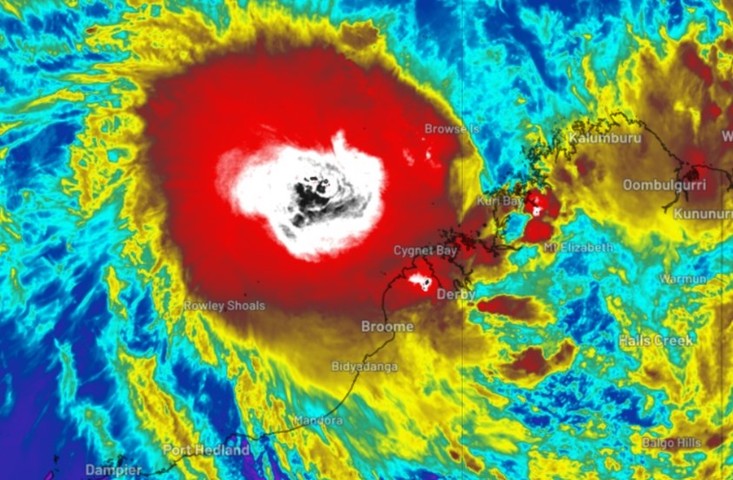
Tropical Cyclone Ilsa has officially been declared, and is expected to intensify rapidly in coming hours and days,

Just after 2 pm AWST, the BoM issued official notice that the tropical low it had been watching with interest for days had formed into a Category 1 cyclone, with sustained winds near the centre of 75 km/h and gusts to 100 km/h.

It was located approximately 400 kilometres NNW of Broome and 700 kilometres NNE of Port Hedland, moving SW at 13 km/h.

The Bureau also said:

  • TC Isla is expected to intensify further during Tuesday and Wednesday as it moves southwest, parallel to the Kimberley coast
  • There’s a significant risk it will become a severe tropical cyclone on Wednesday
  • It is expected to track to the S and then SE during Thursday, with a severe impact likely along the coast and adjacent inland areas between Port Hedland and Broome during late Thursday or early Friday

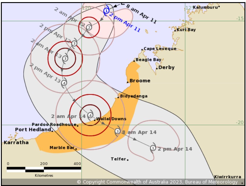
Image: As you can see, the cyclone is expected to be Cat 4 as it crosses the coast. That means sustained winds close to 200 km/h and gusts well over 200 km/h. Source: BoM.

The last cyclone originating in Australian waters to make landfall on the mainland was Cyclone Ellie on December 22, 2022.

While that storm’s winds didn’t cause widespread damage, the system was notable because of its persistence as a tropical low which delivered flooding rains far inland for weeks.

There are early indications that Ilsa could also bring heavy rains far inland, albeit to different parts of the interior. But before that happens, its immediate impacts on coastal communities and nearby areas could be far more severe.

DTN APAC provides detailed specific forecasts to clients when a tropical cyclone is expected to impact them. We provide detailed forecasts of wind, rainfall, and waves for you particular unique assets so you know what weather is headed your way. To find out more, please email us at apac.sales@dtn.com.

Latest news

Satisfy your weather obsession with these news headlines from around the nation, and the world.

Madden-Julian Oscillation increasing tropical cyclone potential for northern Australia industries

Sea surface temperatures exceeding 31°C off the coast of northern Australia and an active phase of the Madden-Julian Oscillation (MJO) are increasing the likelihood of early-season tropical cyclone activity, with hints of the season’s first tropical cyclone coming as early as next week. Tropical cyclones require sea surface temperature of 26.5°C or warmer to develop, […]

Tropical cyclone season begins with warm oceans surrounding northern Australia

The 2025-26 tropical cyclone season has begun with abnormally warm oceans surrounding northern Australia, signalling an increased risk for severe tropical cyclones in the coming months. The Australian tropical cyclone season runs from November 1 to April 30. During this six-month period, there are usually about 9 to 10 tropical cyclones in the Australian region, […]

7.8 million lightning pulses detected by DTN’s Total Lightning Network over Australia in one week

A barrage of thunderstorms battered large areas of eastern and northern Australia over the past week, producing close to 8 million lightning pulses across the country and more than 4 million over Queensland alone. DTN’s Total Lightning Network (TLN) detected around 7.79 million lightning pulses above Australia last week. This lightning was observed over every […]

Warmest October on record for Sydney, Brisbane

Sydney and Brisbane just had their warmest October on record, despite a relatively cool end to the month. A surge of cold air caused temperatures to plummet in eastern Australia earlier this week. In Brisbane, the temperature only reached 22.2°C on Tuesday, while Sydney’s maximums remained below 18°C on both Tuesday and Wednesday. These chilly […]