
It didn’t break the drought, but a decent drop of rain over the long weekend was a welcome change for parched areas of Victoria, South Australia and Tasmania.
A low pressure complex and an associated series of cold fronts delivered multiple rounds of rain and snow across southern and southeastern Australia over the King’s Birthday long weekend.
The map below shows an estimation of how much rain fell across the region during the past five days.

Image: Estimated observed rainfall during the 120 hours ending at 9am AEST on Tuesday, June 10, 2025.
Five-day rainfall totals of about 20 to 50 mm were observed in South Australia, Victoria, Tasmania and southern NSW. Some areas saw heavier falls, including the mainland alps and southwest Victoria. Mount Sabine, located on the Otway Ranges in Victoria, received 130 mm of rain in the 48 hours ending at 9am AEST on Monday, June 9.

Image: Rainfall deficiencies between February 2024 and May 2025. Source: Bureau of Meteorology.
The rain that fell over the long weekend covered areas that have been abnormally dry for a very long time.
Rainfall accumulations since the start of 2025 have been running more than 50 mm below the long-term average in parts of South Australia, Victoria and Tasmania. At the end of May, year-to-date rainfall deficiencies were even exceeding 200mm in parts of Victoria and 400 mm in some areas of Tasmania. These 2025 rainfall deficiencies built on longer-term shortages that have plagued the region over the last couple of years.
Fortunately, the rain from the past week helped reduce rainfall deficiencies in some areas. However, it wasn’t enough to completely eradicate them in many areas.
The maps below show the rainfall from the past week compared to the rainfall anomalies from the first five months of 2025.
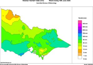
Image: Observed rainfall in Victoria during the week ending at 9am on June 9, 2025. Source: Bureau of Meteorology.

Image: Observed rainfall anomalies in Victoria during the first five months of 2025. Source: Bureau of Meteorology.

Image: Observed rainfall in South Australia during the week ending at 9am on June 9, 2025. Source: Bureau of Meteorology.

Image: Observed rainfall anomalies in South Australia during the first five months of 2025. Source: Bureau of Meteorology.

Image: Observed rainfall in Tasmania during the week ending at 9am on June 9, 2025. Source: Bureau of Meteorology.

Image: Observed rainfall anomalies in Tasmania during the first five months of 2025. Source: Bureau of Meteorology.
Southern and southeastern Australia will need to see more healthy rain-bearing systems this winter to further reduce or wipe out the longer-term rainfall deficiencies. With the past week’s rain in the ground, at least the season is off to a positive start.
How DTN APAC helped agriculture and forestry industries prepare for drought conditions
From Forestry to Agriculture across Australia, Asia Pacific, and globally, you can strengthen your business’ response to long-term weather impact when you work with our diverse team, bringing you global forecasting, product development, and analytics expertise.
We work hard to identify your operational pressures and tailor our services and products to meet your needs. Concise communication, giving you full situational awareness exactly when you need it, is our focus. We want to reduce weather risk in your operations, every day.
Whether it’s preparing for next seasons sowing, irrigation or harvesting, or simply ensuring your operations team is equipped to confidently make decisions ahead of severe weather, our weather Risk Communicators are here for you.
Our weather risk communicators deliver short- to long- term guidance from:
- hourly-event weather monitoring (alerting you of impending thunderstorms and heavy rain).
- week to month operational planing based on likely timing of increased rain or persistent dry periods.
- seasonal long term planning based on climate drivers and the likely trends across the coming months.
As seen below, long range forecasts provided by our weather risk communicators at the start of autumn allowed drought affected industries to prepare for continued rainfall deficiencies over the coming months.

Early indications on rainfall, temperature and wind patterns through our seasonal briefings can save your business millions of dollars, and help effective long-term planning of operations.
We deliver clear and comprehensive weather data, personalised risk assessments and briefings to you and your team, so that your critical decisions can be made with confidence.
We are available 365 days a year, so you always have the timely guidance you require, especially when severe conditions hit.
You have our insights to rely on to see you through complex situations, minimising potential loss of profit and maximising the safety of your staff and assets.
Learn more about our large range of industry leading products and services or email us at sales.apac@dtn.com


