Prosper in a dynamic world
Search

Australia’s equal 10th warmest March on record

Australia just had one of its warmest Marches on record as La Niña’s end brought drier and warmer weather to large parts of the country.

Australia’s mean temperature last month was 1.11ºC above the 1961-1990 average, making it the nation’s equal 10th warmest March in 114 years of records.

This late season-heat was most noticeable in eastern and central Australia, where large areas experienced temperatures in the highest 10 percent of historical records.

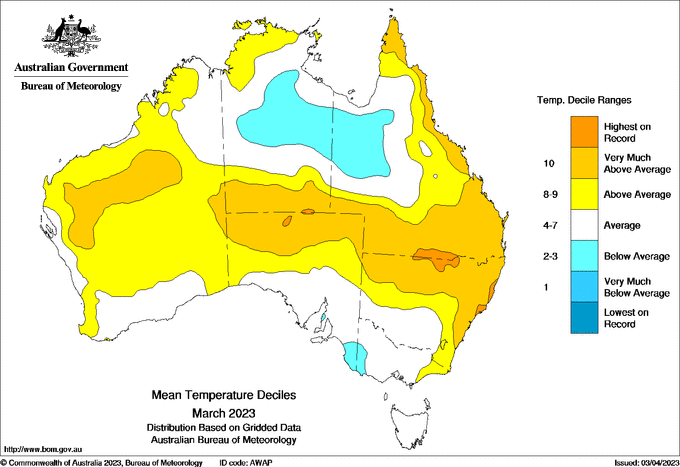
Image: Observed mean temperature deciles during March 2023. Source: Bureau of Meteorology

A few places even managed to set new records. In NSW and Qld, there were 10 weather stations with more than 30 years of observations that registered their highest average March maximum temperature on record.

Sydney was one of the places that set a record for the month, with a mean maximum temperature of 27.6ºC, a whopping 2.8ºC above the long-term average.

Rainfall was mixed across Australia in March, with below average rain in parts of northern and central Australia, and well above average to record-breaking falls in pockets of eastern inland NSW, northwest Qld, the eastern NT and inland WA.

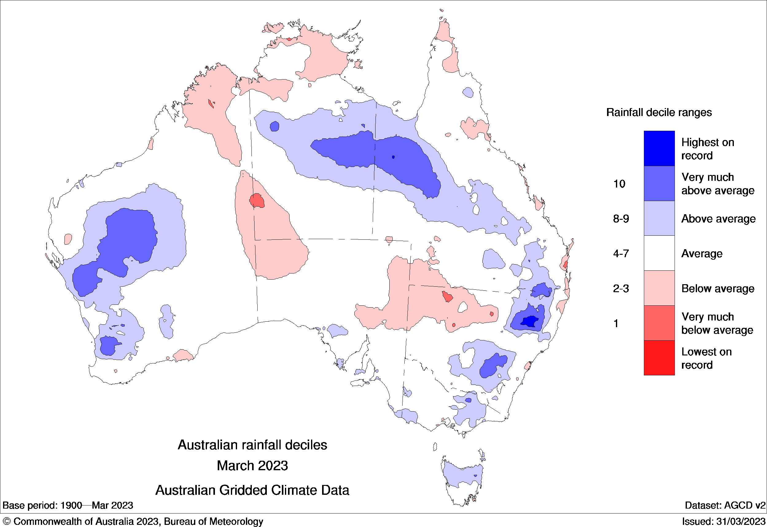
Image: Observed rainfall deciles during March 2023. Source: Bureau of Meteorology

Looking ahead, the potential for El Niño and a positive IOD later this year are increasing the likelihood of below average rain and above-average daytime temperatures over most of Australia during the rest of autumn into early winter.

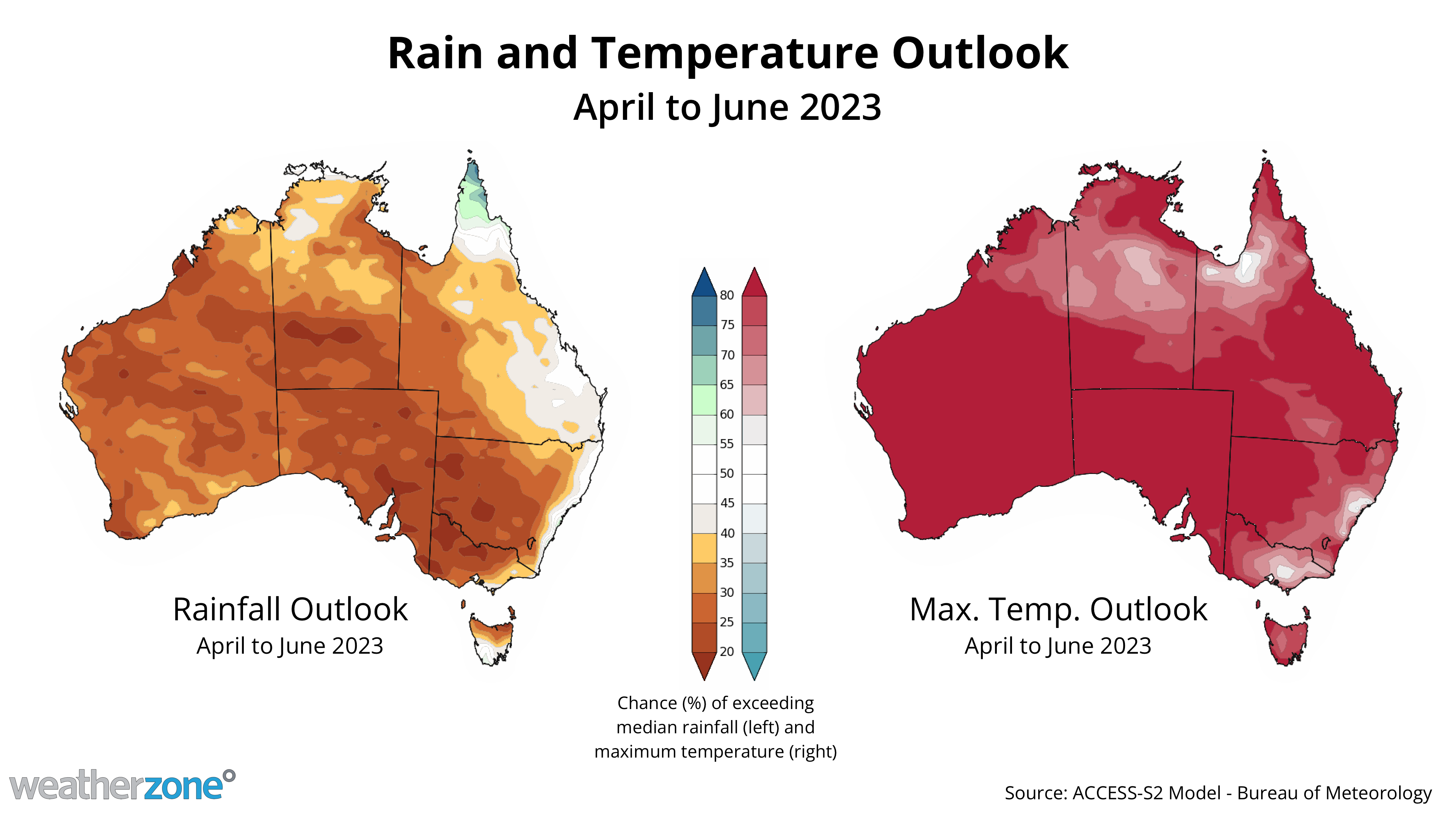
Image: Rainfall and maximum temperature outlooks for the next three months combined. Source: Bureau of Meteorology

DTN APAC can provide tailored climate briefings to your business to alert you of the most likely weather conditions and hazards to look out for during the upcoming season. Now is a good time to get a good look at the forecast for autumn and winter. To find out more or to book a presentation, please email apac.sales@dtn.com.

Latest news

Satisfy your weather obsession with these news headlines from around the nation, and the world.

How does DTN help businesses monitor bushfire induced pyrocumulonimbus thunderstorms that ignite more fires?

Intense heat from bushfires during elevated fire danger days can trigger fire-induced pyrocumulonimbus thunderstorms that ignite additional fires. In early January 2026, an extreme heatwave sweeping over southeastern Australia brought catastrophic fire danger to Victoria. Intensely hot bush and grass fires spread erratically and quickly in hot, dry and gusty winds, with pyrocumulonimbus generating lightning, […]

Active seas to the north and east of Australia disrupting port and maritime operations

Seas to the north and east of Australia are experiencing periods of increased activity this week, leading to disruptions to port, maritime and offshore operations. Intense and hazardous Tasman Sea Ocean conditions across NSW’s South Coast rapidly deteriorated last Friday as a deep feed of easterly winds whipped up large and dangerous seas. The Batemans […]

Transport, emergency and energy industries flooded across Greater Sydney with weekend deluges

Transport, emergency, energy and port industries in eastern NSW and Sydney were impacted by significant flash flooding with intense and heavy rainfall this weekend. Rainfall rates between 80 and 140mm in one to three hours were registered across parts of Sydney’s Northern Beaches and Central Coast on Saturday afternoon and evening. In some areas, these […]

DTN Dangerous Thunderstorm Alerts in action with severe thunderstorms disrupting Perth industries

Severe thunderstorms impacted southwest WA and the Perth region on Sunday, December 14, 2025, triggering Dangerous Thunderstorm Alerts (DTA) by DTN for industries and businesses in the region. DTN operates Dangerous Thunderstorm Alerts (DTA) which alert businesses and industries to thunderstorms based on intensity and movement. These alerts provide advanced notice of thunderstorms moving into […]