Prosper in a dynamic world
Search

BoM declares La Nina officially over

It’s over. La Niña and the wetter-than-usual weather it typically brings to large parts of Australia is officially behind us.

Last week, the U.S. Climate Prediction Center (CPC) declared that the 2022/23 La Niña had ended, paving the way for a return of drier and warmer weather in Australia.

Today Australia’s Bureau of Meteorology came to the party.

“La Niña has ended in the tropical Pacific Ocean. The El Niño–Southern Oscillation (ENSO) is now neutral (neither La Niña nor El Niño) with oceanic and atmospheric indicators having returned to neutral ENSO levels,” the BoM announced on Tuesday.

The BoM went on to say that neutral conditions are expected to persist through autumn, however there are signs that El Niño could form later in the year.

Indeed the BoM has issued an El Niño Watch, which means a 50% chance of an El Niño in 2023.

El Niños typically bring drier, warmer weather than usual across Australia, and in the past have contributed to some of the country’s worst droughts.

READ MORE: WHAT IS LA NIÑA AND HOW DOES IT IMPACT OUR WEATHER?


BoM declares La Nina officially over

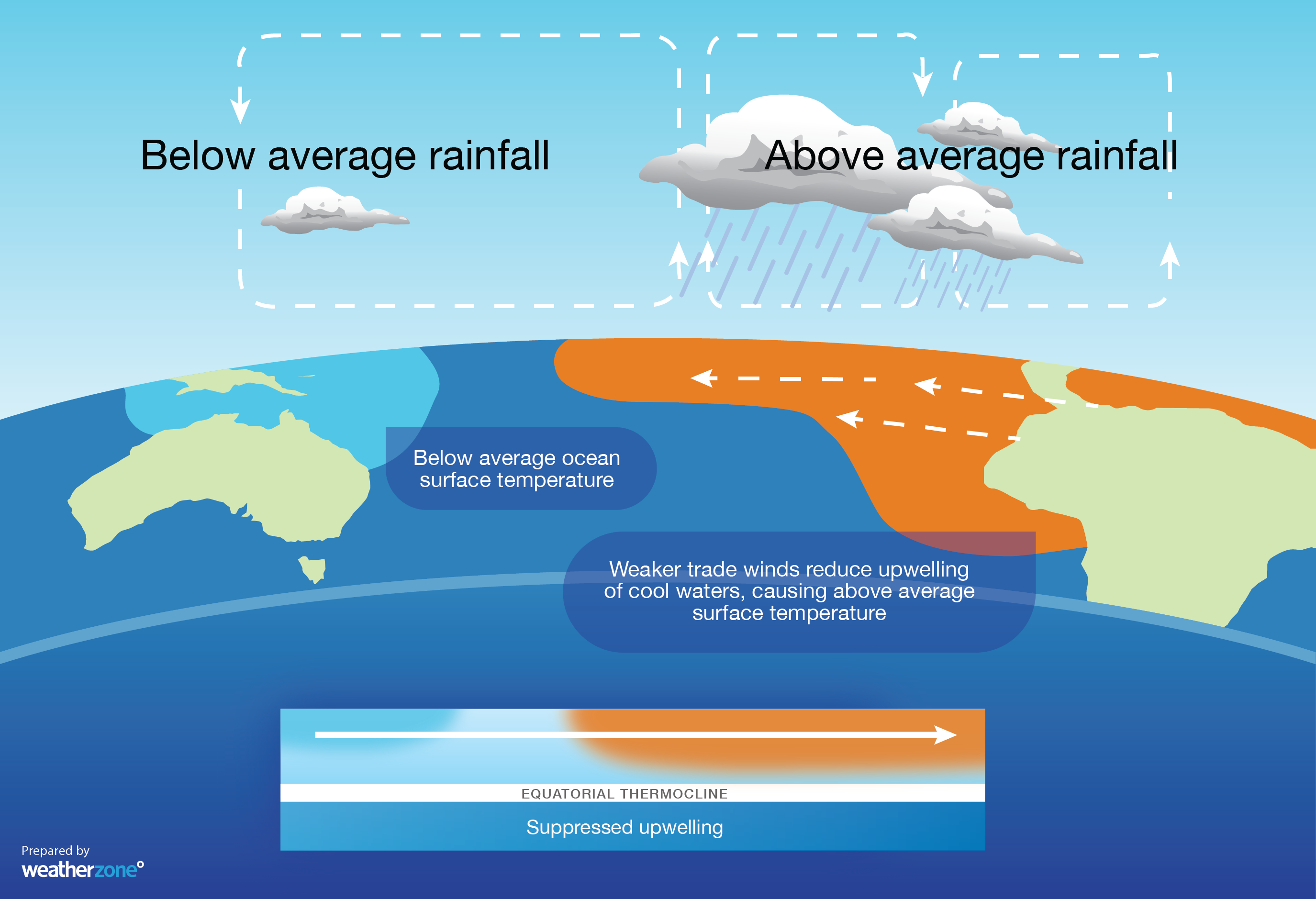
Image: The graphic shows how El Niño impacts Australian weather.

DTN APAC can provide tailored climate briefings to your business to alert you of the most likely weather conditions and hazards to look out for during the upcoming season. Now is a good time to get a good look at the forecast for autumn and an early look at winter. To find out more or to book a presentation, please email apac.sales@dtn.com.

Latest news

Satisfy your weather obsession with these news headlines from around the nation, and the world.

El Niño Is Here: What a Potential Record Event Means for Southeast Asia and Australia

  El Niño was officially declared in June 2026, raising the prospect of widespread impacts across Southeast Asia, from extreme heat and water shortages to higher energy demand and agricultural stress.   The World Meteorological Organization has warned countries to “prepare for it to be severe”, while several global forecast models suggest the event could rank among […]

How El Niño will shape Australian port operations in winter-spring 2026

Australian ports and marine pilots can expect a season of shifting wind and swell patterns through winter and spring 2026, as a developing El Niño brings the likelihood of drier conditions and more variable operating windows across the country’s coastline.  Will El Niño develop in 2026?  There are clear signs that an El Niño pattern is becoming […]

From Kimberley to northern NSW: Bushfire outlook flags risk for resources sector this winter

Bushfire risk doesn’t usually make headlines in June, but AFAC’s winter seasonal outlook is putting mining and resources operators on alert from the Kimberley to the NSW.  Australia’s official seasonal bushfire outlook for winter 2026 was released by AFAC on Thursday, May 28. The outlook predicts increased fire risk across the northern parts of the Great Sandy Desert and surrounds […]

The signal was there weeks earlier: forecasting one of the year’s biggest wind events

In mid-May 2026, DTN APAC meteorologists flagged a strengthening Southern Ocean pattern in model guidance, signalling an extended run of record-challenging wind conditions across the NEM.  Nearly three weeks later, NEM wind generation climbed from around 1.5GW to more than 9GW, supplying roughly one-third of the grid and coming within 1GW of the all-time generation record.  The event highlighted […]