Prosper in a dynamic world
Search

Storms barrel towards three capital cities

Severe storms have ripped through Melbourne and Canberra on Thursday morning, delivering brief but heavy downpours in many suburbs, with the strong chance of more to come in both cities, as well as Sydney.

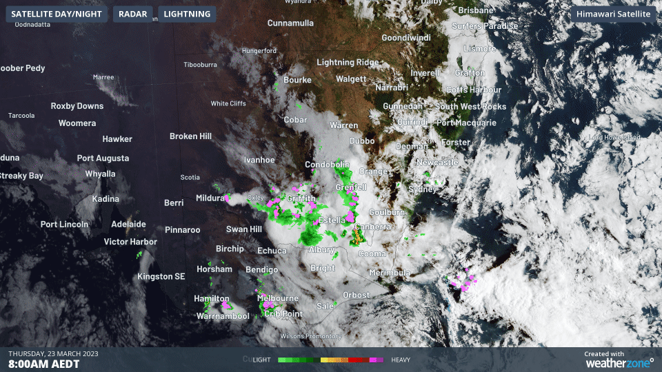
The storms in Canberra and Melbourne struck just after 9 am, as you can see on the radar loop below which covers the period between 8 am and 10 am Thursday.

The timing meant that commuters weren’t too badly affected, however as mentioned, we haven’t seen the last of the storm activity for the day.

The BoM has issued numerous warnings, the latest being a severe thunderstorm warning for the Melbourne area at 9:53 am Thursday, noting that the first severe thunderstorm has cleared to the east of the metro area, but another storm is approaching the Ballarat area and may become severe.

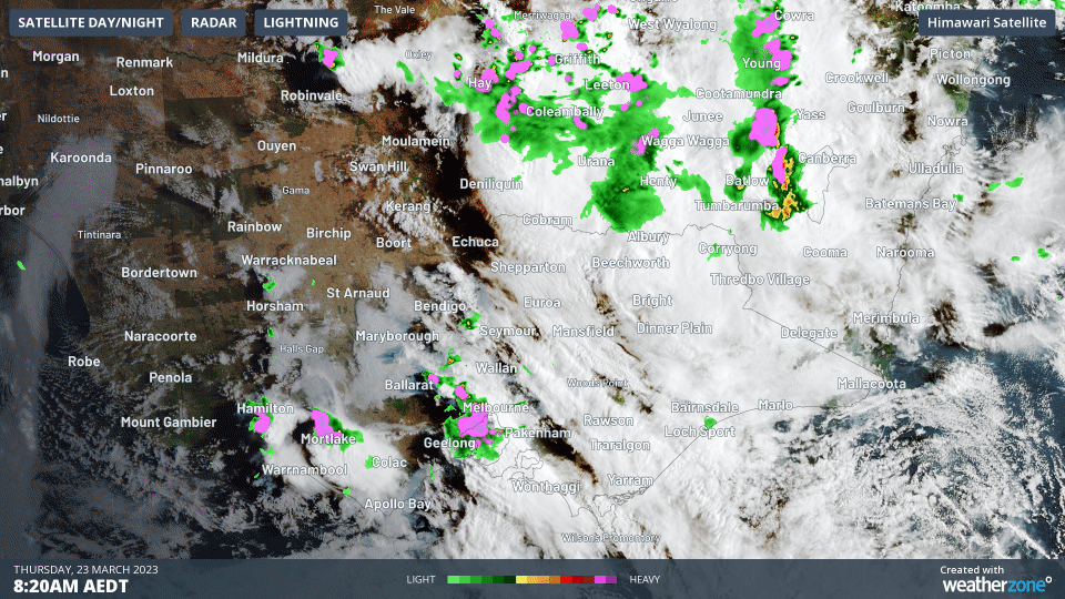
You can see that next storm marching through Ballarat in the general direction of Melbourne in the two-hour loop below, which shows the radar from 8:30 am to 10:30 am.

At the top of the loop, you can also see the storm that hit Canberra heading eastwards with bands north of it heading towards the greater Sydney metro area.

How much rain has fallen in this morning’s storms?

We wrote on Wednesday that the city and most suburbs of Melbourne only saw a millimetre or so of rainfall on a night when much heavier rain fell further north.

The city of Melbourne has again only seen 1.4 mm in Thursday’s first storm, while up to 15 mm fell in the outer eastern suburbs. These totals may well increase in coming hours as the next band of storms approaches.

Meanwhile Canberra has received a total of 15.4 mm on Thursday morning as we write this story, and that tally also seems likely to increase with another band approaching the national capital.

To find out bout DTN APAC and its weather forecasts and alerting services, please visit our website or email us at apac.sales@dtn.com.

Latest news

Satisfy your weather obsession with these news headlines from around the nation, and the world.

How Australian East Coast port and maritime operations could be disrupted by tropical cyclones over the next two weeks

Port and maritime operations across Australia’s East Coast could be disrupted by increased tropical cyclone activity in the Coral Sea and southwest Pacific Ocean over the next two weeks. Meteorologists reference a large selection of Numerical Weather Prediction (NWP) models to forecast weather. A number of these NWP models are forecasting the development of tropical […]

Extreme fire danger and severe heatwave conditions spreading across SA, Victoria and NSW

Hot, dry and windy weather causing elevated fire danger and severe heatwave conditions are sweeping across southeastern Australia over the next three days, driving high energy demand and disruption to operations. Clear skies associated a large and slow-moving high pressure system have allowed hot air to build up over parts of northern, western and central […]

Heightened bushfire risk during the 2025-26 summer for WA, Victoria and NSW in latest AFAC Outlook

The Australian and New Zealand Council for fire and emergency services (AFAC) identified western and southern WA, Victoria and inland NSW as key regions that are at risk of heightened bushfire risk this summer. Parts of Australia have experienced severe soil moisture and rainfall deficiencies over the past months and years, while high fuel loads […]

Southeast Asia hit by deadly widespread flooding with three tropical cyclones, including rare Malacca Strait cyclone

Three tropical cyclones: Senyar, Koto and Ditwah, have brought widespread deadly flooding to parts of southeast Asia over the past week, including Indonesia, Malaysia, Thailand, the Philippines and Sri Lanka. Extensive disruptions to industries, government and communities is expected as the rescue, clean up and recovery extend over the coming months. Senyar brings devastation to […]