
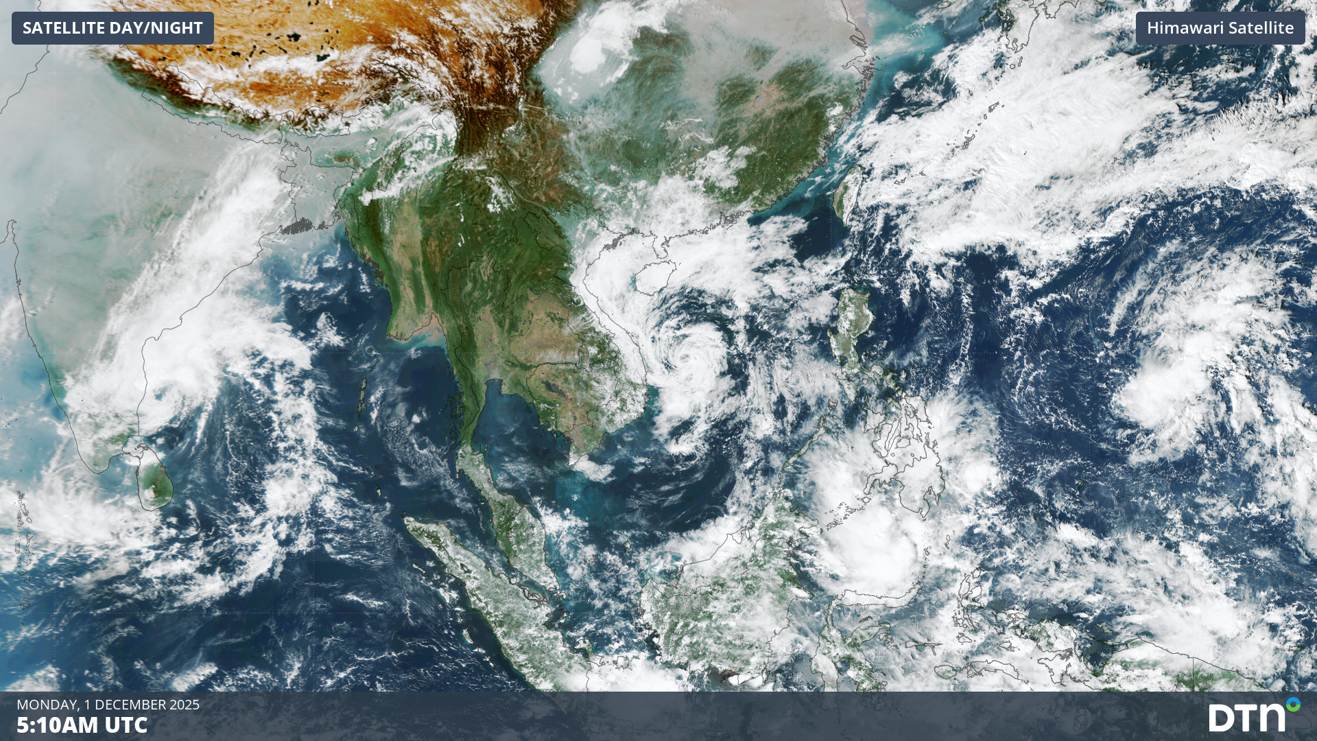
Three tropical cyclones: Senyar, Koto and Ditwah, have brought widespread deadly flooding to parts of southeast Asia over the past week, including Indonesia, Malaysia, Thailand, the Philippines and Sri Lanka. Extensive disruptions to industries, government and communities is expected as the rescue, clean up and recovery extend over the coming months.
Senyar brings devastation to Indonesia and the Malaysian Peninsula
Early last week, the Indian Meteorological Department (IMD) issued warnings for a rare tropical cyclone in the Malacca Strait called Senyar. According to MetMalaysia, this is the first tropical storm to intensify in the strait that separates Indonesia’s Sumatran Island, and the Malay Peninsula. The region rarely experiences tropical storm strength systems due to the proximity to the equator, which limits the Coriolis Force required for tropical cyclones to form.
Devastation across the region came with the torrential rainfall as monsoonal winds wrapped around Senyar, delivering hundreds of millimetres of rain within short periods of time. The map below shows rainfall estimates over the past week and Senyar’s track, however the worse affected areas of North Sumatra, Aceh, northeast Malaysia and southern Thailand have received rainfall accumulations exceeding the maximum denomination of the scale (300mm).
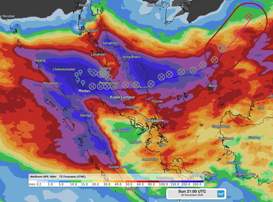
Image: Quantitative Precipitation Estimates (QPE) as seen on the DTN Stormtracker dashboard across Sumatra and the Malay Peninsula in the week to 5am local time on Monday, December 1, 2025, along with Tropical Cyclone Senyar’s past and future track.
Along with the torrential deluge, flooding over the region was also enhanced by the Barisan and Titiwangsa mountain ranges in Indonesia and the Malay Peninsula, respectively. The deep flow of moist monsoonal winds moving over the mountains resulted in heavy precipitation which flowed into the already flood affected areas.
Flooding and landslides have caused at least 600 deaths across Indonesia, Thailand and Malaysia, with rescue and relief efforts disrupted by destruction and closures of roads, airports and other transport infrastructures.
The remnants of Senyar moved off the east coast of Malaysia late last week. Daily showers will continue to affect the region over the coming week, bringing rainfall accumulations of 60-100mm. While further flooding is not expected, persistent showers could delay the flood water withdrawals.
Sri Lanka hit by deadly flooding with Tropical Cyclone Ditwah
In the north Indian Ocean, Tropical Cyclone Ditwah tracked roughly parallel to Sri Lanka’s south and east coastlines late last week. Much of the country received rainfall in excess of 300mm over less than three days, leading to widespread and devastating flooding.
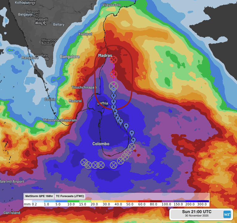
Image: Quantitative Precipitation Estimates (QPE) across Sri Lanka and southern India in the week to 2:30am local time on Monday, December 1, 2025, along with Tropical Cyclone Ditwah’s past and future track.
Sri Lanka’s death toll is approaching 200 lives lost, with rescue and relief efforts also encountering severe difficulties with the destruction to essential transport and utility infrastructures.
Ditwah has since weakened after moving north of Sri Lanka, but heavy rainfall should continue to impact southern and eastern Tamil Nadu and coastal Andhra Pradesh over the next 3-4 days.
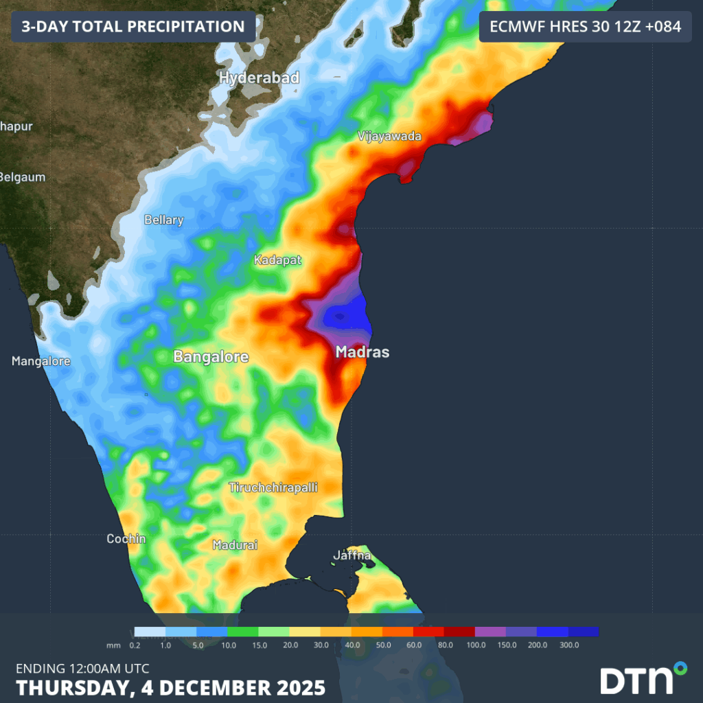
Image: Forecast rainfall accumulations in the three-day period to Thursday morning, December 4, 2025, showing heavy rainfall from the remnants of Ditwah impacting southern India.
Tropical storms lining up into the South China Sea
The satellite loop below shows two areas of convection to the west and east of the Philippines.
Video: Infrared satellite imagery showing Tropical Storm Koto approaching Vietnam, and another area of convection well east of the Philippines which could intensify over the coming week.
Tropical Storm Koto was briefly a typhoon over the South China Sea late last week, marking the 14th typhoon of the Western Pacific Typhoon season, and 27th named system. It has since weakened, but impacts are being felt as it approaches Vietnam, with heavy falls expected over coastal and central Vietnam this week.
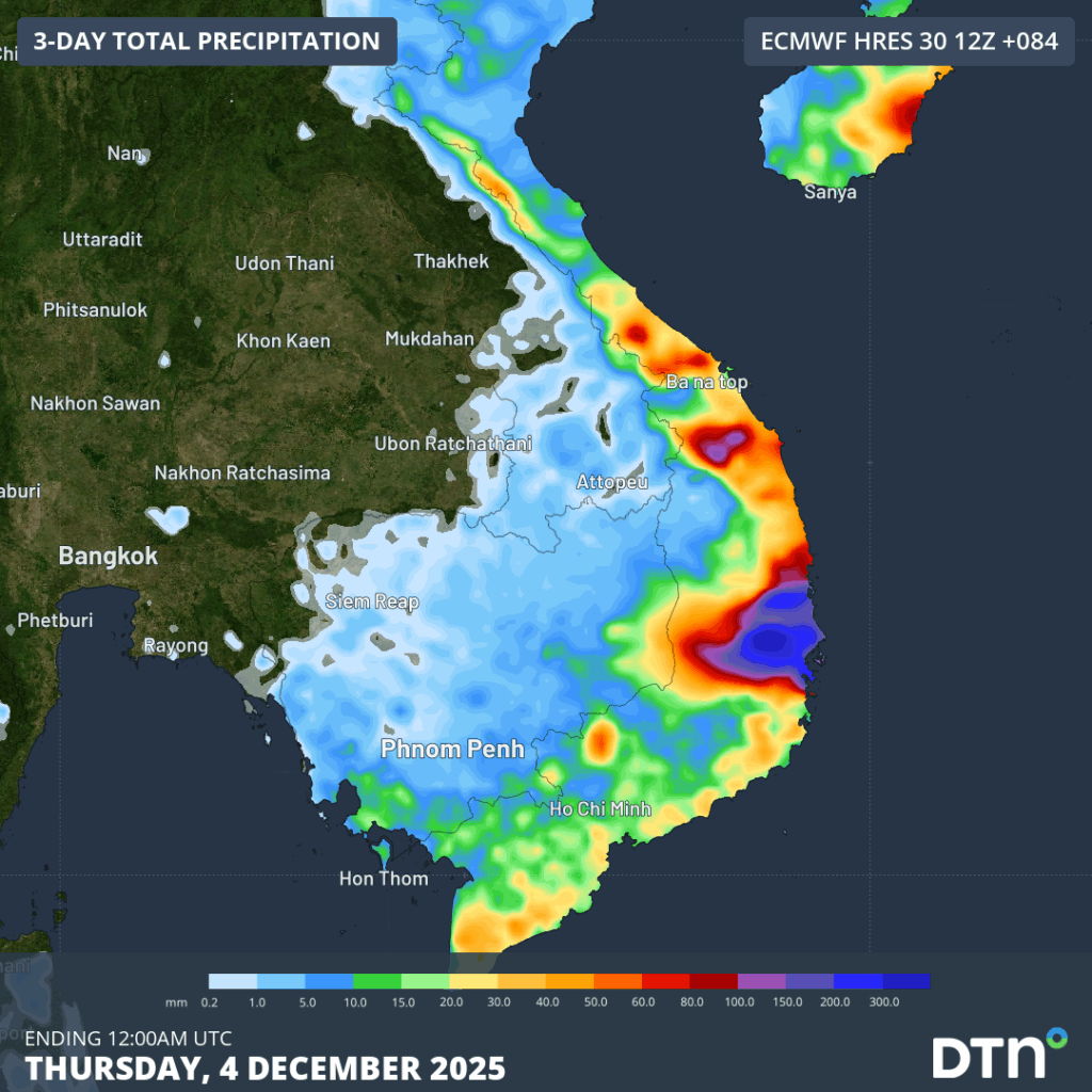
Image: Forecast rainfall accumulations in the three-day period to Thursday, December 4, 2025, across Vietnam.
Further east in the Pacific is an area of convection that could become more organised as the week goes on. Parts of the Philippines could become impacted late this week and into early next week if the system develops, with Vietnam potentially receiving another round of heavy rainfall next week if the system continues to track westwards.
How DTN APAC supports businesses, government and communities through tropical cyclones and typhoons
DTN APAC specialises in industry-leading forecast, alerting and threat analysis of tropical cyclones across Australia and Asia, offering you expert, customised solutions when the weather turns wild.
Providing rapid-update forecast information, we alert you to any low-pressure system gaining power within your region and, unlike other providers, can track its development out to 7 days. This gives you the time to prepare and safeguard your staff, sites and assets.
You will have the most precise weather intelligence charting rainfall, wind speeds and potential storm surges to help you make critical decisions quickly. Whether it’s adjusting key work schedules, protecting your staff or securing your site, we have the alerting capability to keep you steps ahead of the storm.
As the climate delivers increasingly severe weather events, their potential to impact your business operations grows.
Whether it’s preparing for the coming season’s tropical storm potential, or rapid-response forecasting with a typhoon approaching, or simply ensuring your operations team is equipped to confidently make decisions ahead of severe weather, our weather Risk Communicators are here for you.
Our weather risk communicators deliver short- to long-term guidance from:
- hourly-event weather monitoring (alerting you of impending destructive winds and heavy rain ahead of a tropical cyclone).
- week to month operational planning based on likely timing of increased monsoonal rain or periods of reduced cyclone activity.
- seasonal long term planning based on climate drivers and the likely trends across the coming months.
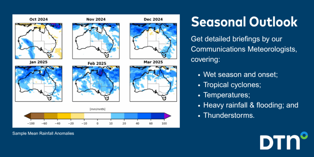
We deliver clear and comprehensive weather data, personalised risk assessments and briefings to you and your team, so that your critical decisions can be made with confidence.
We are available 365 days a year, so you always have the timely guidance you require, especially when severe conditions hit.
You have our insights to rely on to see you through complex situations, minimising potential loss of profit and maximising the safety of your staff and assets.
Learn more about our large range of industry leading products and services or email us at sales.apac@dtn.com




