Prosper in a dynamic world
Search

Rain for almost whole country over next 10 days

It’s not going to rain everywhere, every day, let’s be clear about that. But a series of weather systems will deliver rain to virtually all parts of Australia over the coming 10 days.

The graphic below shows the total accumulated rainfall which we can expect between today (Monday, September 26) and next Wednesday, October 5.

As you can see, heavy rain is expected in the southeast, and indeed we wrote about that earlier today in this story, as yet another rain and storm-bearing low pressure trough crosses the most heavily populated corner of the country.

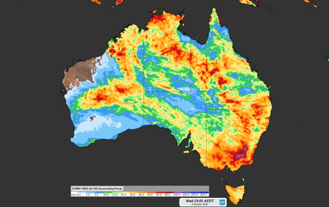
Image: It’s not often you see the whole country “coloured in” like this. Source: ECWMF.

But as mentioned, the picture above speaks about more than this week’s system.

Numerous weather systems are expected to impact the country in the next 10 days or so, including a low pressure trough which could deliver significant unseasonable rainfall to northwest WA’s Kimberly and Pilbara districts early next week.

Those two regions experience almost no rainfall on average at this time of year.

  • For example Broome, on the Kimberly coast, has had no rainfall in September 2022 to date.
  • Indeed Broome’s two driest months are Sept and Oct, with an average of just 1.4 mm in each month.
  • Yet Broome is located right where one of those reddish blobs sits, suggesting potential rainfall in the 50-80 mm range.

You might also note that the graphic above shows Darwin getting an early October drenching, and while the heart of the Top End wet season falls in midsummer and early autumn, October has an average of 70.2 mm, so a decent Darwin drop is not too unusual at this time of year.

It’s still too early predict exactly how that particular system will play out. But as mentioned, we can say with confidence that almost the entire country can expect to see at least some rain between now and the middle of next week.

We’ll keep you updated as these systems start to make their impact felt.

For more information on Weatherzone’s heavy rainfall, thunderstorm and cloud forecasting services, please contact us at apac.sales@dtn.com.

Latest news

Satisfy your weather obsession with these news headlines from around the nation, and the world.

From Kimberley to northern NSW: Bushfire outlook flags risk for resources sector this winter

Bushfire risk doesn’t usually make headlines in June, but AFAC’s winter seasonal outlook is putting mining and resources operators on alert from the Kimberley to the NSW.  Australia’s official seasonal bushfire outlook for winter 2026 was released by AFAC on Thursday, May 28. The outlook predicts increased fire risk across the northern parts of the Great Sandy Desert and surrounds […]

The signal was there weeks earlier: forecasting one of the year’s biggest wind events

In mid-May 2026, DTN APAC meteorologists flagged a strengthening Southern Ocean pattern in model guidance, signalling an extended run of record-challenging wind conditions across the NEM.  Nearly three weeks later, NEM wind generation climbed from around 1.5GW to more than 9GW, supplying roughly one-third of the grid and coming within 1GW of the all-time generation record.  The event highlighted […]

The 2026 Indian Southwest Monsoon onset is expected in the next two weeks

The Indian Southwest Monsoon will reach India in the next two weeks, but a developing El Niño could signal a drier than normal monsoon for businesses and major industries across the country. Southwest monsoon onset over southern India in the next two weeks The Indian Meteorological Department (IMD) is responsible for tracking the advance and […]

Rapid El Niño signal accelerating risk for Australian businesses

El Niño–favourable conditions are gathering pace across the tropical Pacific, with key ocean indicators approaching threshold levels and early atmospheric responses emerging.  While uncertainty remains around final El Niño strength, historical analogues show that even weak events can generate widespread impacts, including reduced rainfall, warmer daytime temperatures, increased frost risk, elevated fire danger, reduced tropical cyclone activity, and more. Industries including […]