Fierce winds, severe thunderstorms and heavy rain are expected to lash Southwest WA during the next 48 hours.
A low-pressure system and associated cold front will sweep across southwestern Australia on Tuesday afternoon, bringing a mix of wild winterlike weather.
The satellite image below shows the low pressure system and associated cloud approaching the west coast on Monday morning.

Image: Visible satellite image captured on Monday morning.
While the sky was mostly clear across southwestern WA on Monday morning, cloud and rain are expected to increase from Monday afternoon into Tuesday as the low and front arrive.
The image below shows one model’s forecast rainfall during 48 hours ending at 8pm AWST on Tuesday, with 30-60mm forecast along southern parts of the state’s western coastline and isolate pockets of 60-80mm likely.
 Thunderstorms are also likely to impact the southwest of WA overnight Monday into Tuesday, with heavy rainfall and damaging wind gusts possible in some of these storms.
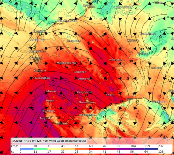
Strong winds independent of thunderstorms will also impact southwestern districts of WA later today through to Wednesday as the cold front and low move through. Winds are likely to peak on Tuesday and Wednesday, when damaging gusts in excess of 90 km/h are possible in some areas.
The map below shows the instantaneous wind gust forecast on Tuesday afternoon, with strong and gusty winds impacting much of central and southern WA.

Image: ECMWF instantaneous wind gust forecast at 2pm WST, Tuesday, September 13.
In addition to the rain and strong winds, temperatures will also drop to around 2-3 degrees below average in Perth from Tuesday and Friday in the wake of the front.
Check the latest severe weather and thunderstorm warnings for the most up-to-date information on this system. For more information on Weatherzone’s thunderstorm, heavy rainfall and strong winds forecasting and alerting, please contact us at apac.sales@dtn.com.


