Prosper in a dynamic world
Search

Thunderstorms and flooding to hit WA


Heavy rain, thunderstorms and flooding could impact parts of northwestern WA during the next 48 hours as moisture-laden air travels towards WA from the Indian Ocean. 

The satellite image below shows thick cloud streaming across western WA on Friday morning with rain falling along the coast. 

 cur-sat-rad-lig-au_au-tight_1920x1080

Image: Visible satellite image and radar at 10:20am on Friday, September 2. 

This cloud is forming as tropical moisture from the Indian Ocean feeds into a low-pressure system currently sitting off the Gascoyne coast. 

This system is expected to bring moderate to heavy rainfall and thunderstorms to parts of the southern Pilbara, Gascoyne Coast and Central West districts on Friday.  

Heavy rainfall and thunderstorms will continue and spread further east on Saturday, impacting the Pilbara, Gascoyne and parts of the South Interior, Goldfields, Central West and Central Wheatbelt districts.  

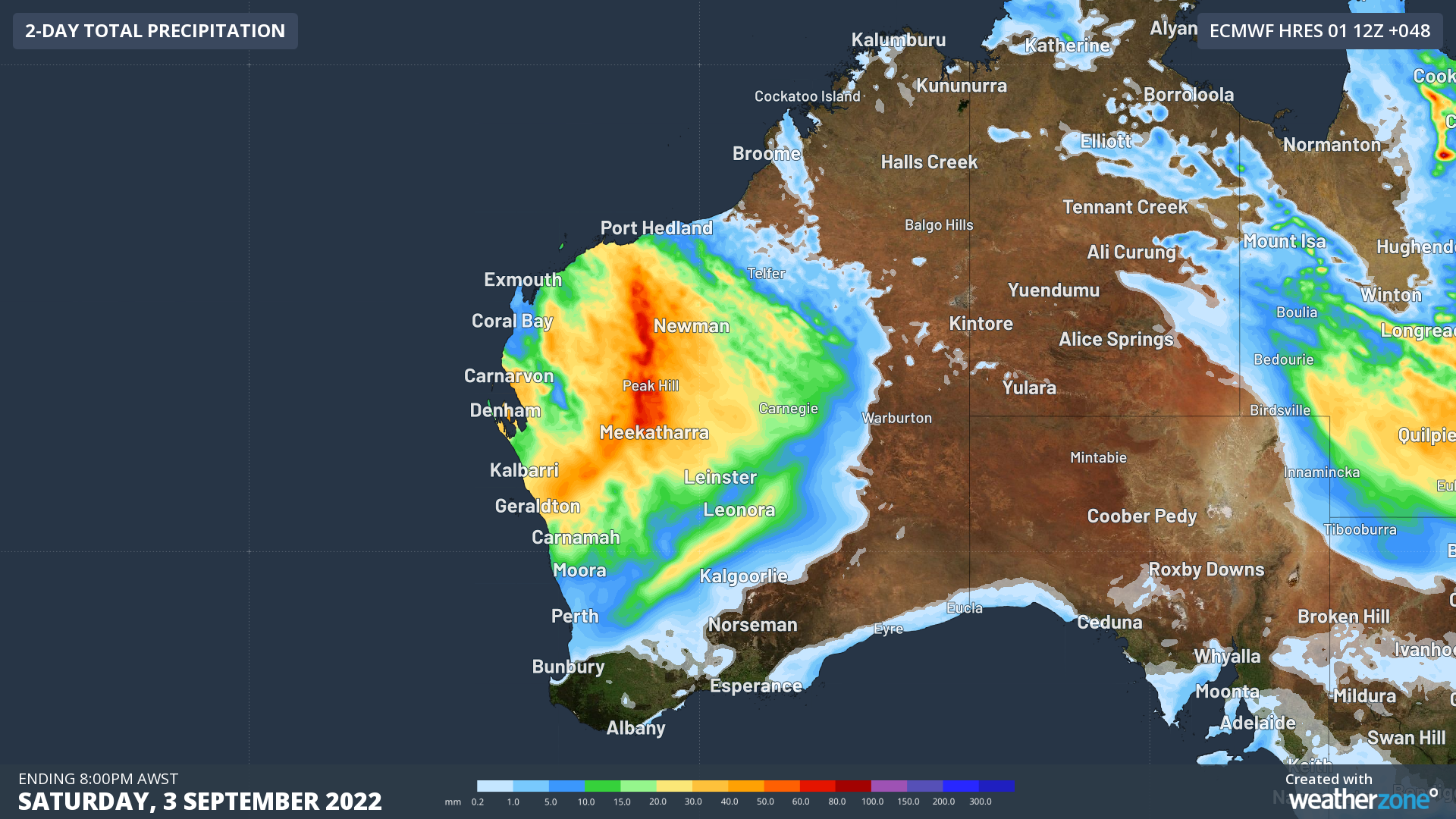
The map below shows the forecast rainfall expected during the next 48 hours. 

 nwp-pcp-ecmwf-hres-048_au-wa_1920x1080

Image: ECMWF 48 hour forecast rainfall to 10pm Saturday, September 3. 

Unfortunately, many catchments in these districts are already wet, which makes river rises and flooding of low-lying areas a heightened risk.  

The heavy rainfall and flooding could also cut off roads, highways and may isolate communities in these districts.  

Heavy rainfall should ease over the northwest of WA on Sunday as the wet weather moves into the state’s Northern and Southern Interior.  

Looking further ahead, another frontal system will deliver another burst of rain across most the state on Monday and Tuesday next week. Fortunately, the falls from this system shouldn’t be too heavy for most areas. 

The map below shows one model’s forecast rainfall for the next seven days, with widespread falls of 30-60mm forecast across western WA and isolated pockets of 60-80mm forecast in the Pilbara and Gascoyne regions. 

 nwp-pcp-ecmwf-hres-168_au-wa_1920x1080

Image: ECMWF weekly rainfall forecast to 8pm, Thursday, September 8. 

 For more information on Weatherzone’s thunderstorm or heavy rainfall alerting, please contact us at apac.sales@dtn.com.

Latest news

Satisfy your weather obsession with these news headlines from around the nation, and the world.

El Niño Is Here: What a Potential Record Event Means for Southeast Asia and Australia

  El Niño was officially declared in June 2026, raising the prospect of widespread impacts across Southeast Asia, from extreme heat and water shortages to higher energy demand and agricultural stress.   The World Meteorological Organization has warned countries to “prepare for it to be severe”, while several global forecast models suggest the event could rank among […]

How El Niño will shape Australian port operations in winter-spring 2026

Australian ports and marine pilots can expect a season of shifting wind and swell patterns through winter and spring 2026, as a developing El Niño brings the likelihood of drier conditions and more variable operating windows across the country’s coastline.  Will El Niño develop in 2026?  There are clear signs that an El Niño pattern is becoming […]

From Kimberley to northern NSW: Bushfire outlook flags risk for resources sector this winter

Bushfire risk doesn’t usually make headlines in June, but AFAC’s winter seasonal outlook is putting mining and resources operators on alert from the Kimberley to the NSW.  Australia’s official seasonal bushfire outlook for winter 2026 was released by AFAC on Thursday, May 28. The outlook predicts increased fire risk across the northern parts of the Great Sandy Desert and surrounds […]

The signal was there weeks earlier: forecasting one of the year’s biggest wind events

In mid-May 2026, DTN APAC meteorologists flagged a strengthening Southern Ocean pattern in model guidance, signalling an extended run of record-challenging wind conditions across the NEM.  Nearly three weeks later, NEM wind generation climbed from around 1.5GW to more than 9GW, supplying roughly one-third of the grid and coming within 1GW of the all-time generation record.  The event highlighted […]