Prosper in a dynamic world
Search

Melbourne’s coldest morning in four years


Melbourne and other parts of Victoria just endured their coldest morning since 2018, with more than half of the state registering temperatures below zero degrees.

A high pressure system passing over southeastern Australia on Tuesday night, in the wake of a cold front, caused a wintry combination of cold air, clear skies and light winds. These conditions created the perfect environment for efficient overnight radiative cooling, which caused the mercury to plummet.

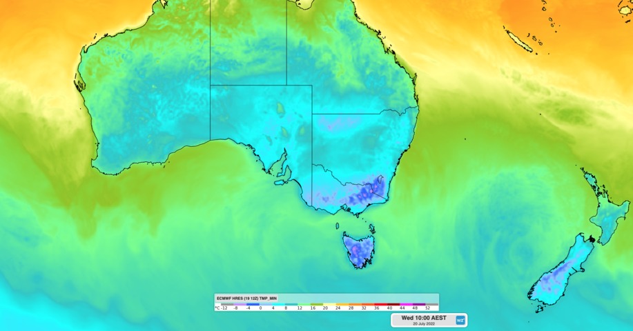
Image: Modelled minimum air temperature on Wednesday morning.

In Victoria, 41 of the state’s 79 weather stations registered temperatures below zero degrees on Wednesday morning. The lowest in the state was -7.4ºC at Mt Hotham.

Closer to Melbourne, Coldstream hit a teeth-chattering -3.8ºC and the airport at Tullamarine dropped to -1.5ºC. The city itself reached a low of 0.8ºC shortly before 8am. These were all the lowest temperatures since 2018.

Parts of southern NSW also copped a taste of this morning’s wintry chill. Perisher Valley in the Snowy Mountains reached -11.7ºC, which was the lowest temperature anywhere in Australia for two years. Thredbo Top Station, the country’s highest weather station, also had its coldest morning in four years, dipping to -10.6ºC.

Tasmania also shivered through another cold start this morning, with Liawenee reaching -9.1ºC and Launceston Airport -4.0ºC. This was Launceston’s lowest temperature since 2019.

Temperatures on Thursday morning will once again be cold enough for widespread frost across southeastern Australia. However, most places will be slightly warmer than they were this morning and overnight temperatures will continue to climb later in the week. For more information, please contact us at apac.sales@dtn.com.

Latest news

Satisfy your weather obsession with these news headlines from around the nation, and the world.

Perth sets rainfall streak not seen in 18 years as water storage levels fall

For four months in a row, Perth has exceeded its average monthly rainfall – the first time this has happened in the traditionally wet winter and spring period since 2007. Perth reached its September average of 79.3mm during light showers on Tuesday and Wednesday. Another 13.2mm of rain then fell in the 24 hours to […]

DTN remote sensing captures rain and thunderstorms lashing Solomon Islands

Aviation, mining and shipping industries in the Solomon Islands and other South Pacific nations are often unable to use traditional radar to warn of incoming storms that disrupt operations and put workers in harm’s way. DTN APAC offers a suite of remote sensing weather solutions that give businesses and industries in remote areas around the […]

Negative Indian Ocean Dipole officially underway – here’s what it means for Australian businesses and industries

A negative Indian Ocean Dipole (IOD) event is now underway, increasing the likelihood of above average rain over large parts of Australia in the coming months. What is the Indian Ocean Dipole (IOD)? The IOD is an index used to monitor sea surface temperatures across the tropical Indian Ocean. It’s an important index for the […]

La Niña more likely this year after BoM switches to new index – what does this mean for Australian businesses?

The likelihood of La Niña occurring in 2025 has increased due to a change in the way the Bureau of Meteorology calculates sea surface temperature anomalies in the tropical Pacific Ocean. What is La Niña? La Niña refers to a distinct pattern of sea surface temperatures across the tropical Pacific Ocean. When La Niña is […]