Prosper in a dynamic world
Search

Sydney’s coldest start to winter since 1989


Bob Hawke was Australia’s prime minister when Sydney last experienced an opening week of winter this cold.

The temperature at Sydney’s Observatory Hill failed to reach 18.5ºC during the first six days of June and is expected to top out at around 17ºC today.

While these maximum temperatures are close to the city’s long-term June average of 17ºC, it’s rare to see a run of days this cold at the start of winter in the modern climate.

The last time the first seven days of June stayed below 18.5ºC at the Observatory Hill weather station was in 1989. Prior to that year, such a feat was more common.

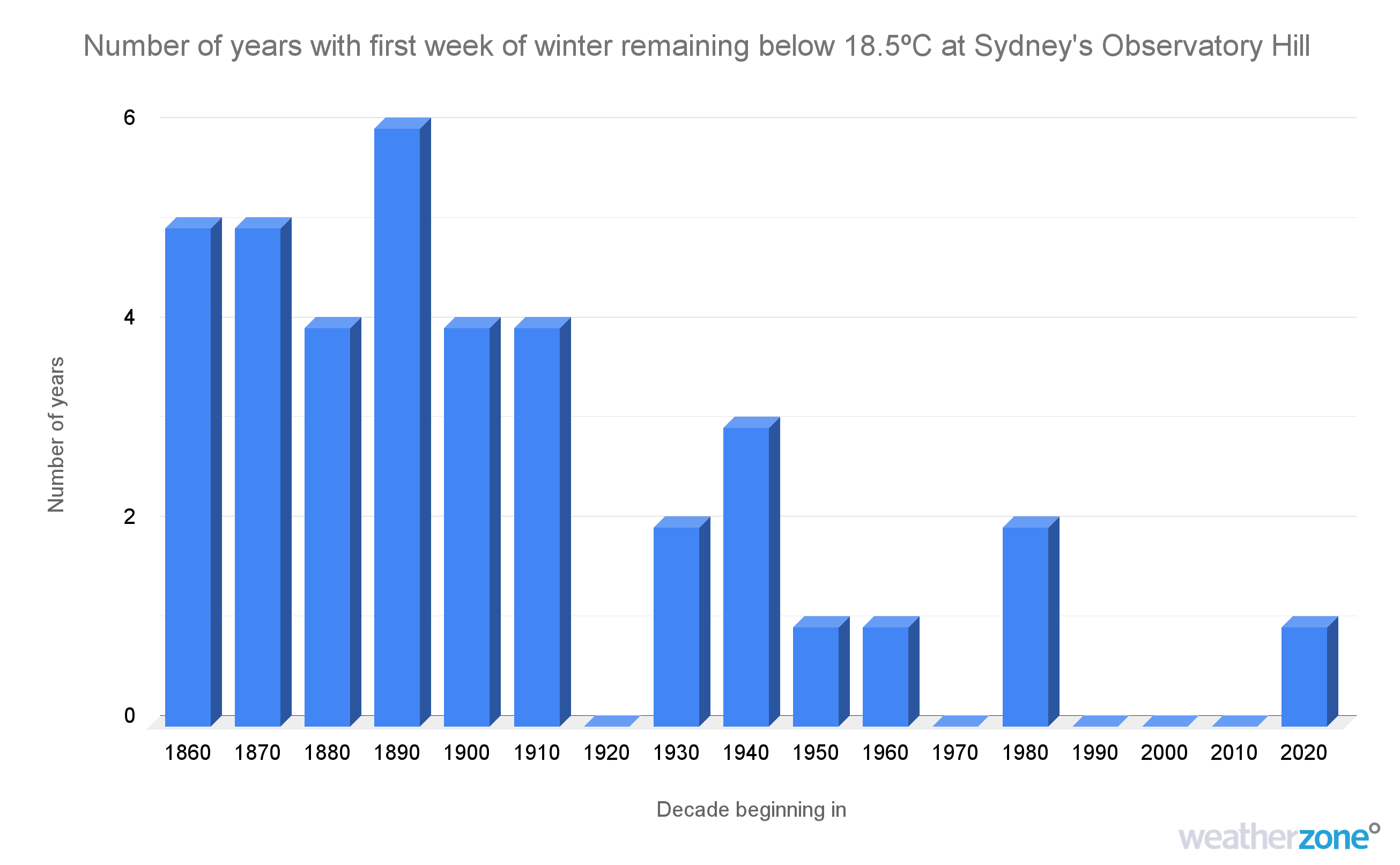
Image: Number of years per decade where Sydney’s Observatory Hill weather station failed to reach 18.5ºC during the first week of winter.

So, what caused such a cold start to winter this year?

Sydney and the rest of southeastern Australia has been hit by a flurry of cold fronts over the past week. This stagnant wintry weather pattern has caused a sustained stream of cold air to flow over Australia’s southeastern states.

This week is a good example of how cold periods of weather can still occur in a warming climate. But as the graph above shows, such cold spells are happening less frequently as the background climate continues to get warmer.

Australia’s average maximum temperature during winter has warmed by around 1.5ºC since 1910.

Weatherzone conducts detailed seasonal forecasts which can help with long-term planning out to six months. The seasonal forecasts are tailored to the business and can include risk of heavy rainfall and flood risk, tropical cyclones, thunderstorms, extreme heat, bushfires and much more. These forecasts can be delivered live online or face to face, allowing time for questions and increasing engagement.  

 For more information on our products or how we can help you with your business needs, please contact us at apac.sales@dtn.com

Latest news

Satisfy your weather obsession with these news headlines from around the nation, and the world.

High tropical cyclone risk near northern Australia this week

A tropical low currently developing over the Timor Sea has a high chance of becoming a tropical cyclone later this week, with a possibility of landfall somewhere in the Northern Territory or Western Australia. Key industries could be impacted including Ports, Mining, Transport, and Agriculture. The satellite images below show cloud circulating around the developing […]

Madden-Julian Oscillation increasing tropical cyclone potential for northern Australia industries

Sea surface temperatures exceeding 31°C off the coast of northern Australia and an active phase of the Madden-Julian Oscillation (MJO) are increasing the likelihood of early-season tropical cyclone activity, with hints of the season’s first tropical cyclone coming as early as next week. Tropical cyclones require sea surface temperature of 26.5°C or warmer to develop, […]

Tropical cyclone season begins with warm oceans surrounding northern Australia

The 2025-26 tropical cyclone season has begun with abnormally warm oceans surrounding northern Australia, signalling an increased risk for severe tropical cyclones in the coming months. The Australian tropical cyclone season runs from November 1 to April 30. During this six-month period, there are usually about 9 to 10 tropical cyclones in the Australian region, […]

7.8 million lightning pulses detected by DTN’s Total Lightning Network over Australia in one week

A barrage of thunderstorms battered large areas of eastern and northern Australia over the past week, producing close to 8 million lightning pulses across the country and more than 4 million over Queensland alone. DTN’s Total Lightning Network (TLN) detected around 7.79 million lightning pulses above Australia last week. This lightning was observed over every […]