Prosper in a dynamic world
Search

Tropical cyclone Karim forms out of season


A late-season tropical cyclone over the Indian Ocean will fuel rainfall over southwestern Australia later this week. 

Australia’s tropical cyclone season officially ended more than a week ago April 30th. However, unusually warm water over the eastern Indian Ocean has helped spawn an out-of-season tropical cyclone just inside the western boundary of Australia’s area of responsibility. 

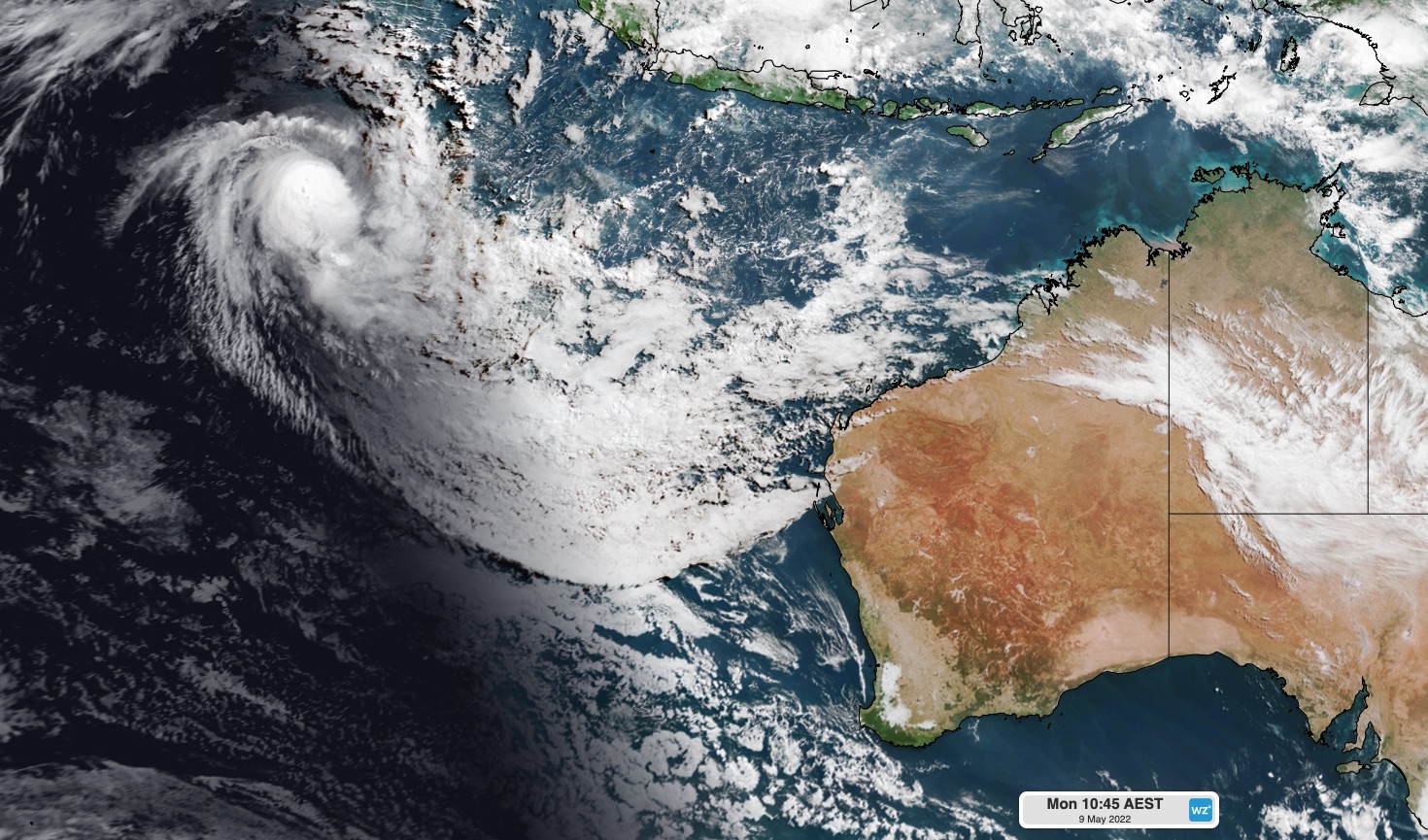
Tropical cyclone Karim developed well to the northwest of WA on the weekend and strengthened into a category two system overnight. At 2am AWST on Monday, Karim was located 700 km west of Cocos Island. 

 MicrosoftTeams-image (394)

Image: The sun rises over Tropical Cyclone Karim on Monday morning. 

Fortunately, Tropical Cyclone Karin is expected to move south and gradually weaken over the next few days, staying well away from the Cocos (keeling) Islands and mainland Australia. 

However, tropical moisture associated with the weakening cyclone will drift south and bring rain to southwestern Australia on Thursday and Friday. 

Showers will start to increase over the west coast of WA from late Wednesday, before rain becomes heavier and more widespread on Thursday into Friday. 

The map below shows how much rain one computer model is predicting by Friday night. 

 MicrosoftTeams-image (393)

Image: Forecast accumulated rain between Monday and Friday this week, according to the ECMWF-HRES model. 

Tropical Cyclone Karim is the 10th tropical cyclone to move through the Australian region since the start of the 2021/22 tropical cyclone season in November 2021. For more information on Weatherzone’s tropical cyclone services, please contact us at apac.sales@dtn.com. 

Latest news

Satisfy your weather obsession with these news headlines from around the nation, and the world.

El Niño Is Here: What a Potential Record Event Means for Southeast Asia and Australia

  El Niño was officially declared in June 2026, raising the prospect of widespread impacts across Southeast Asia, from extreme heat and water shortages to higher energy demand and agricultural stress.   The World Meteorological Organization has warned countries to “prepare for it to be severe”, while several global forecast models suggest the event could rank among […]

How El Niño will shape Australian port operations in winter-spring 2026

Australian ports and marine pilots can expect a season of shifting wind and swell patterns through winter and spring 2026, as a developing El Niño brings the likelihood of drier conditions and more variable operating windows across the country’s coastline.  Will El Niño develop in 2026?  There are clear signs that an El Niño pattern is becoming […]

From Kimberley to northern NSW: Bushfire outlook flags risk for resources sector this winter

Bushfire risk doesn’t usually make headlines in June, but AFAC’s winter seasonal outlook is putting mining and resources operators on alert from the Kimberley to the NSW.  Australia’s official seasonal bushfire outlook for winter 2026 was released by AFAC on Thursday, May 28. The outlook predicts increased fire risk across the northern parts of the Great Sandy Desert and surrounds […]

The signal was there weeks earlier: forecasting one of the year’s biggest wind events

In mid-May 2026, DTN APAC meteorologists flagged a strengthening Southern Ocean pattern in model guidance, signalling an extended run of record-challenging wind conditions across the NEM.  Nearly three weeks later, NEM wind generation climbed from around 1.5GW to more than 9GW, supplying roughly one-third of the grid and coming within 1GW of the all-time generation record.  The event highlighted […]