A dangerous multi-day deluge is likely to cause flooding in parts of QLD and NSW next week, however there is still a lot of uncertainty about how much rain will fall and which areas will be affected.
What can be said about this event, now
An upper-level cut-off low is expected to move across central Australia early next week before passing over QLD and northern NSW from Wednesday into the second half of the week.
This upper-level low will interact with a sustained stream of moisture-laden air from the Coral Sea to cause a prolonged period of heavy rain and thunderstorms. This weather setup is unusual over northeastern Australia during May and is being bolstered by the lingering La Niña in the Pacific Ocean.
This dynamic weather pattern is likely to produce heavy rain across a broad area of QLD and northern NSW next week, most likely between Tuesday and the weekend.
What can’t be said about this event, yet
While there is good agreement between forecast models that a major rain and flooding event will affect parts of QLD and NSW next week, there are still some large areas of uncertainty.
The position of the upper-low next week is almost impossible to predict at this stage. The images below show the predicted position of the upper-low on Wednesday and Friday next week, according three of the most reputable global weather models. While there is fairly good model agreement with the location and strength of the low on Wednesday, things become less certain by Friday. 

Image: Forecast 500 hPa temperature and height from three different forecast models, showing 10pm AEST on Wednesday, May 11 (top) and 10am AEST on Friday, May 13 (bottom).
The location of the upper-low will have a big influence on where rain falls over QLD and NSW next week. If it stays further west, the heavier rain is likely to target inland areas of eastern Australia. However, if it drifts more towards or over the coast, this will see the biggest falls and greatest flood risk occurring along the coast and ranges. The north-south movement of the low will also determine if heavier rain falls in north tropical QLD or southern QLD and northern NSW.
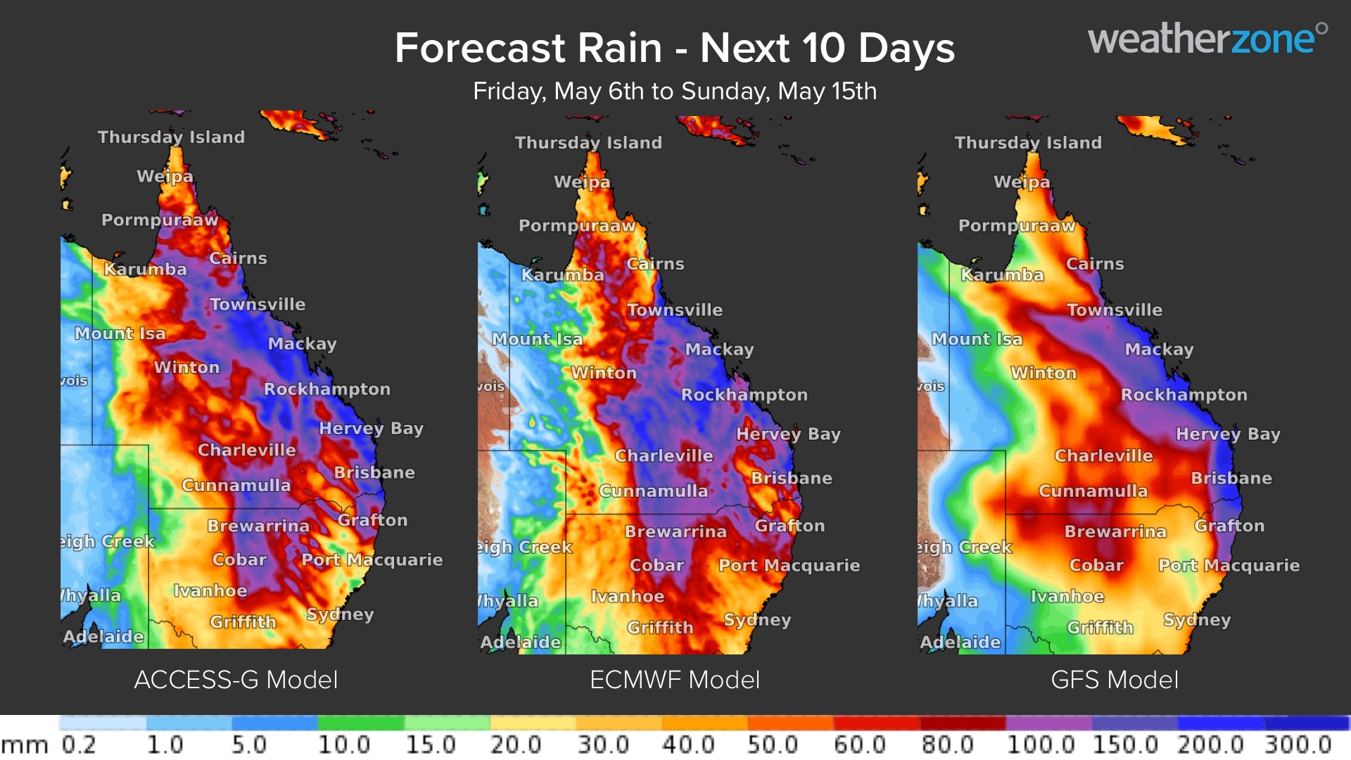
The maps below show the forecast accumulated rainfall between now and the end of next week from the same three models as the previous images. While the broad pattern is similar between the three models, there are some striking differences in the location and magnitude of the heaviest rain.

Image: Forecast accumulated rain between now and the end of next week (Friday May 6 to Sunday May 15) from three different forecast models.
While some forecast models are showing signs that several hundred millimetres of rain could hit parts of QLD and NSW next week, it is too early to make detailed predictions for individual locations of regions just yet. This does not mean that it will not happen, just that it is too early to know yet.
Any communities or industries operating anywhere in QLD and or northern NSW should prepare for heavy rain and possible flooding next week and pay close attention to the forecasts and warnings. There is good agreement that the Bowen Basin will be affected by the heavy rainfall event next week, impacting the mining industry in the area. We will provide updates on the heavy rainfall event in QLD and NSW next week as more data becomes available.
Weatherzone’s flood risk system
We have developed a flood risk system which accurately determines rainfall intensity at any given point along your mine site, catchment, road or railway.
The system uses radar technology which typically scans every 6-10 minutes, sending your business regular alerts or updates for your specific mine site or railway using geofencing technology.
Will the flood event subside, continue or worsen? The rainfall risk system is used in combination with Opticast™, an industry leading forecast system which forecasts rainfall intensity and accumulation at your location.
Weatherzone also provides businesses with long term rainfall forecasting solutions out to 6 months, which allows businesses to plan well in advance and reduce the impact on day-to-day operations. For more information, please contact us at apac.sales@dtn.com.


