A dangerous mix of heavy rain and damaging winds will batter parts of Tasmania during the next few days, with flooding likely to develop in some river catchments.
A pool of cold upper-level air passing over southeastern Australia this week will cause a low pressure system to deepen near Tasmania from today.
The low is expected to deepen near the state’s east coast today, before passing over Tasmania tonight and redeveloping off the north coast on Friday and moving away to the east Saturday afternoon and evening.
This dynamic low pressure system will drive heavy rain and powerful winds over Tasmania between Thursday and Saturday.
The heaviest rain and strongest winds are likely to affect the southern and eastern parts of the state, which has prompted a severe weather warning for heavy rainfall and damaging winds.
Heavy rainfall is likely over eastern and southeastern Tasmania from Thursday into Friday morning, with the heaviest falls gradually spreading southwards over this period. Heavy rain could also develop in northern and eastern Tasmania from Friday afternoon into Saturday. At this stage, rain should ease from Saturday afternoon as the low moves away to the east.
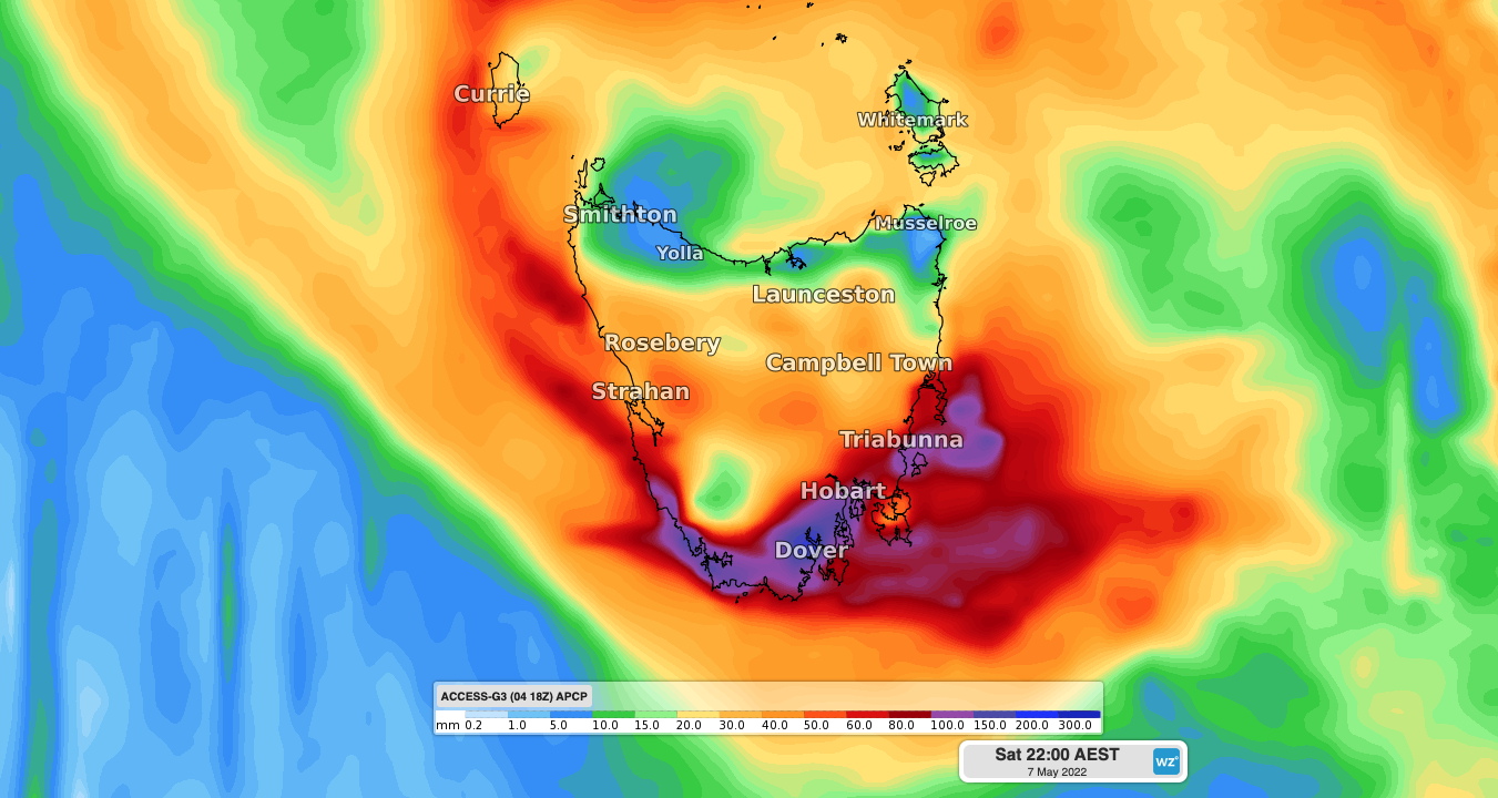
Accumulated rainfall totals of 80 to 100mm could occur between Thursday afternoon and Saturday morning, with pockets of 150 mm possible. Six-hourly rain rates may reach 50 to 100mm at times, particularly over elevated terrain and with thunderstorms in the state’s south. This much rain likely to cause flooding, with a flood watch in place for the South East, Huon, Derwent, North and North East catchments.

Image: ACCESS-G accumulated three-day rainfall up to 10pm Saturday, April 7.
Damaging winds are also likely over parts of southern and eastern Tasmania from Thursday afternoon into Friday morning and may also develop in parts of the state’s north later on Friday. Average wind speeds of 50km/h and wind gusts reaching around 80 to 100 km/h are likely for some areas.

Image: Forecast wind speed and direction at 1am AEST on Friday, May 6, according to the ACCESS-C model.
Wind and rain will ease over Tasmania from late Saturday into Sunday as the low moves out over the Tasman Sea.
This burst of wet weather follows a long run of abnormally dry conditions in the state’s west and south, with most of western Tasmania experiencing their driest November to April period on record.

Image: Rainfall deciles during the last six months (November 2021 to April 2022).
While this week’s rain will cause some flooding in the short term, it should help erase some of Tasmania’s long-term rainfall deficiencies, especially in the south of the state. For more information on Weatherzone’s flood and heavy rainfall alerts, please contact us at business@weathezone.com.au.


