Prosper in a dynamic world
Search

Perth to see its coolest day in five months


Temperatures are set to plummet across southwestern WA during the next few days as a cool airmass sweeps across the region.  

The first cold front will move through the southwest of WA on Tuesday, causing a noticeable drop in temperature in Perth. This system will be followed by another two fronts on Wednesday and Thursday.  

Collectively, these fronts will deliver a burst of cold and wet weather not seen in Perth for months. After reaching 31ºC on Monday,Perth’s temperature is only expected to reach 19-20ºC on Wednesday, Thursday and Friday, which is about 5 to 6ºC below average for mid-autumn. 

Wednesday’s forecast maximum temperature of 19ºC would be the coolest day in five months, with the last 19ºC recorded on November18, 2021.  

The last time Perth stayed below 21ºC for three consecutive days this early in the year was 14 years ago. 

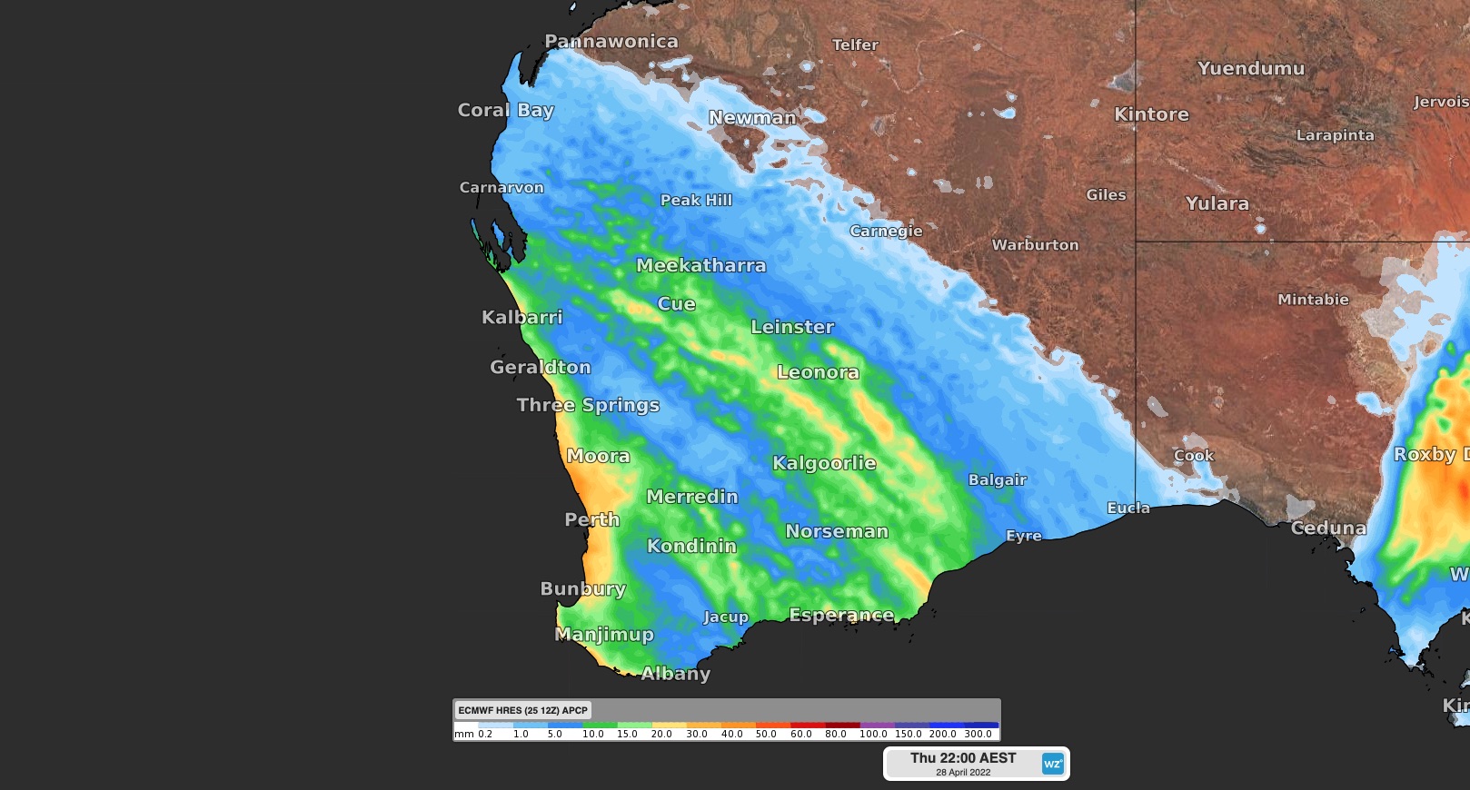
The cold fronts will also bring several days of wet and cloudy weather to southwestern WA as they move through the region. The map below shows the rainfall forecast during the next three days, with 20-40mm possible in Perth. 

 MicrosoftTeams-image (365)

Image: Forecast accumulated rain between Tuesday and Thursday this week, according to the ECMWF-HRES model. 

 This week’s cool and wet weather  after a hot and dry summer, which led to record breaking heat in Perth. Between December and February, Perth registered 32 days at or above 35ºC and 13 days at 40ºC or higher. These were both new summer records. 

 MicrosoftTeams-image (366) 

Thursday and Friday evenings should also be chilly, with temperatures of 9-10ºC forecast. This is about 4 to 5ºC below average for April. 

Fortunately for those that don’t like wet and cool weather, the weekend is looking mostly sunny and temperatures will rise to a pleasant 25ºC by Sunday. For more information on Weatherzone’s energy forecasts, please contact us at apac.sales@dtn.com.

Latest news

Satisfy your weather obsession with these news headlines from around the nation, and the world.

High tropical cyclone risk near northern Australia this week

A tropical low currently developing over the Timor Sea has a high chance of becoming a tropical cyclone later this week, with a possibility of landfall somewhere in the Northern Territory or Western Australia. Key industries could be impacted including Ports, Mining, Transport, and Agriculture. The satellite images below show cloud circulating around the developing […]

Madden-Julian Oscillation increasing tropical cyclone potential for northern Australia industries

Sea surface temperatures exceeding 31°C off the coast of northern Australia and an active phase of the Madden-Julian Oscillation (MJO) are increasing the likelihood of early-season tropical cyclone activity, with hints of the season’s first tropical cyclone coming as early as next week. Tropical cyclones require sea surface temperature of 26.5°C or warmer to develop, […]

Tropical cyclone season begins with warm oceans surrounding northern Australia

The 2025-26 tropical cyclone season has begun with abnormally warm oceans surrounding northern Australia, signalling an increased risk for severe tropical cyclones in the coming months. The Australian tropical cyclone season runs from November 1 to April 30. During this six-month period, there are usually about 9 to 10 tropical cyclones in the Australian region, […]

7.8 million lightning pulses detected by DTN’s Total Lightning Network over Australia in one week

A barrage of thunderstorms battered large areas of eastern and northern Australia over the past week, producing close to 8 million lightning pulses across the country and more than 4 million over Queensland alone. DTN’s Total Lightning Network (TLN) detected around 7.79 million lightning pulses above Australia last week. This lightning was observed over every […]