Prosper in a dynamic world
Search

Autumn chill on the way for southeastern Australia


While ample sunshine and warm weather are forecast for much of southeastern Australia this Easter long weekend, a blast of cooler air will move through the region early next week. 

Adelaide and Melbourne’s daytime temperatures are likely to be around five to eight degrees above the April average between this Thursday and Sunday. 

However, temperatures will become significantly cooler in both cities from Monday as the first of a series of cold fronts and low-pressure troughs move across the nation’s south and southeast.  

The first cold front and low-pressure trough will cause temperature to drop by about 4 to 8ºC in parts of SA, VIC and TAS. Temperatures are set to plummet again later in the week as another strong cold front sweeps across the area on Wednesday.  

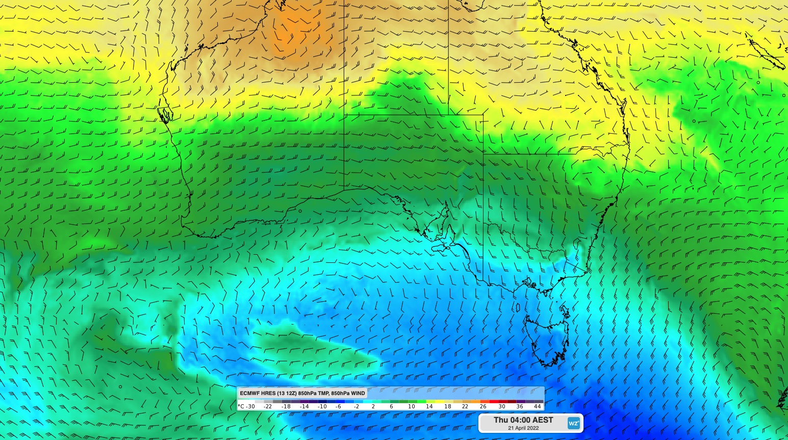
The map below shows a cold airmass moving through southern Australia behind this second front on Wednesday night. 

 MicrosoftTeams-image (357)

Image: Forecast 850 hPa temperature and wind from the ECMWF model, showing cold air moving over southeastern Australia at 4am AEST on Thursday. 

A belt of strong southwesterly winds will also sweep across southeastern Australia from mid-next week, making it feel several degrees cooler than the actual air temperature in both Adelaide and Melbourne.While damaging winds are not expected at this stage, the strong winds are likely to increase wind power across the National Electricity Market (NEM).

The map below shows the wind gusts forecast on Thursday afternoon. 

 MicrosoftTeams-image (356)

Image: Forecast wind gust speed and direction at 4pm AEST on Thursday, April 21, according to the ECMWF-HRES model. 

While the coolest air from this pair of fronts will clip Australia’s southern states, temperatures will also drop in Sydney from Thursday as cool southerly winds spread across NSW. 

Looking further ahead, there a signs that a ridge of high pressure may extend across southeastern Australia on Anzac weekend, promoting another sunny long weekend. For more information on Weatherzone’s energy forecasts, please contact us at apac.sales@dtn.com. 

Latest news

Satisfy your weather obsession with these news headlines from around the nation, and the world.

How does DTN help businesses monitor bushfire induced pyrocumulonimbus thunderstorms that ignite more fires?

Intense heat from bushfires during elevated fire danger days can trigger fire-induced pyrocumulonimbus thunderstorms that ignite additional fires. In early January 2026, an extreme heatwave sweeping over southeastern Australia brought catastrophic fire danger to Victoria. Intensely hot bush and grass fires spread erratically and quickly in hot, dry and gusty winds, with pyrocumulonimbus generating lightning, […]

Active seas to the north and east of Australia disrupting port and maritime operations

Seas to the north and east of Australia are experiencing periods of increased activity this week, leading to disruptions to port, maritime and offshore operations. Intense and hazardous Tasman Sea Ocean conditions across NSW’s South Coast rapidly deteriorated last Friday as a deep feed of easterly winds whipped up large and dangerous seas. The Batemans […]

Transport, emergency and energy industries flooded across Greater Sydney with weekend deluges

Transport, emergency, energy and port industries in eastern NSW and Sydney were impacted by significant flash flooding with intense and heavy rainfall this weekend. Rainfall rates between 80 and 140mm in one to three hours were registered across parts of Sydney’s Northern Beaches and Central Coast on Saturday afternoon and evening. In some areas, these […]

DTN Dangerous Thunderstorm Alerts in action with severe thunderstorms disrupting Perth industries

Severe thunderstorms impacted southwest WA and the Perth region on Sunday, December 14, 2025, triggering Dangerous Thunderstorm Alerts (DTA) by DTN for industries and businesses in the region. DTN operates Dangerous Thunderstorm Alerts (DTA) which alert businesses and industries to thunderstorms based on intensity and movement. These alerts provide advanced notice of thunderstorms moving into […]