Prosper in a dynamic world
Search

Six days of rain and storms in eastern Australia


A prolonged spell of rain and thunderstorms will hit Queensland and NSW during the next six days, with more than 100mm of rain possible in some recently flooded areas of eastern Australia. 

A slow-moving upper-level trough interacting with warm and moisture-laden air will trigger widespread rain and storms in eastern Australia each day between this Thursday and at least Tuesday next week. 

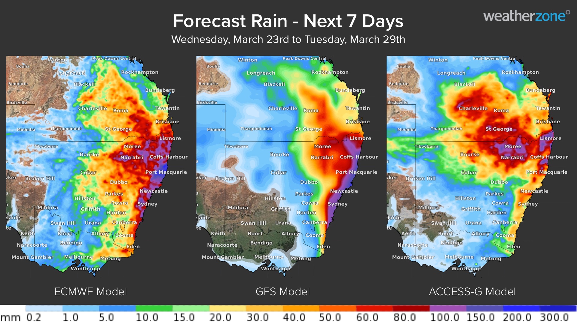
There is still some uncertainty around where and when the rain from this system will fall. However, several forecast models are predicting substantial rain over eastern and northeast NSW. The maps below show the predicted accumulated rain between now and next Tuesday from three forecast models.  

 MicrosoftTeams-image (303)

Image: Forecast accumulated rain during the next week, according to the ECMWF (left), GFS (centre) and ACCESS-G (right) models.

The maps above show that while there is still some model disagreement about rainfall amounts, most models agree that parts of eastern or northeast NSW will be a focus for heavy rain during the coming week. 

Unfortunately, there is potential for accumulated totals in excess of 100 mm in areas of central and northeast NSW that were recently affected by flooding. If this comes off it could cause renewed flooding in some areas. 

With so much uncertainty still at play around this potentially high impact weather event, it will be important to regularly check the latest forecasts, warnings and flood watches in your area over the coming week. 

Weatherzone meteorologists will be closely monitoring this event and can provide regular updates to clients in this region, for more information, please contact us at apac.sales@dtn.com.

Latest news

Satisfy your weather obsession with these news headlines from around the nation, and the world.

High tropical cyclone risk near northern Australia this week

A tropical low currently developing over the Timor Sea has a high chance of becoming a tropical cyclone later this week, with a possibility of landfall somewhere in the Northern Territory or Western Australia. Key industries could be impacted including Ports, Mining, Transport, and Agriculture. The satellite images below show cloud circulating around the developing […]

Madden-Julian Oscillation increasing tropical cyclone potential for northern Australia industries

Sea surface temperatures exceeding 31°C off the coast of northern Australia and an active phase of the Madden-Julian Oscillation (MJO) are increasing the likelihood of early-season tropical cyclone activity, with hints of the season’s first tropical cyclone coming as early as next week. Tropical cyclones require sea surface temperature of 26.5°C or warmer to develop, […]

Tropical cyclone season begins with warm oceans surrounding northern Australia

The 2025-26 tropical cyclone season has begun with abnormally warm oceans surrounding northern Australia, signalling an increased risk for severe tropical cyclones in the coming months. The Australian tropical cyclone season runs from November 1 to April 30. During this six-month period, there are usually about 9 to 10 tropical cyclones in the Australian region, […]

7.8 million lightning pulses detected by DTN’s Total Lightning Network over Australia in one week

A barrage of thunderstorms battered large areas of eastern and northern Australia over the past week, producing close to 8 million lightning pulses across the country and more than 4 million over Queensland alone. DTN’s Total Lightning Network (TLN) detected around 7.79 million lightning pulses above Australia last week. This lightning was observed over every […]