Prosper in a dynamic world
Search

Another cyclone is on the cards this week


A tropical low pressure system near the Cocos Keeling Islands has the potential to develop into a cyclone in the Australian region on Tuesday.  

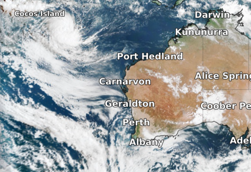
This map below shows cloud encircling the low sitting to the southeast of Cocos Islands on Monday. 

 satellite

Image: Visible satellite image at 8:50am WST on Monday, March 14 showing the low to the southwest of Cocos Island. 

The low will move southwest in the coming days and may gradually intensify into a tropical cyclone during Tuesday. If it does develop into a tropical cyclone inside the Australian Region, it will be named Billy. 

The low is currently moving away from Christmas Island and is forecast to pass well to the south of the Cocos (Keeling) Islands during Tuesday, with little impact expected on these Islands.  

Fortunately, this system will also stay away from the Australian mainland and is unlikely to have any direct impact on WA. 

Unexpectedly quiet cyclone season 

Despite La Niña, Australia has been having a relatively quiet tropical cyclone season so far. Since the start of the cyclone season in November, there have only been six tropical cyclones named inside Australia’s area of responsibility. This is well below the seasonal average of 11-12.  

The last tropical cyclone named in the Australian region was Anika, which impacted the Kimberley in late-February.  

Billy would become the seventh cyclone named in the Australian region this tropical cyclone season.  

There are also signs that another low may form in the Arafura Sea later this week. Models are suggesting this low could move to the west-southwest into the Western Region. While there is only a low risk of this system developing into a tropical cyclone at this stage, it could still enhance rainfall and thunderstorm activity across northern WA later this week. 

Our team of highly skilled or knowledgeable meteorologists at Weatherzone will continue to watch as weather systems evolve. Providing detailed risk analysis and impact advice to our business clients or to you and your business. For more information, please contact us at apac.sales@dtn.com.

Latest news

Satisfy your weather obsession with these news headlines from around the nation, and the world.

How does DTN help businesses monitor bushfire induced pyrocumulonimbus thunderstorms that ignite more fires?

Intense heat from bushfires during elevated fire danger days can trigger fire-induced pyrocumulonimbus thunderstorms that ignite additional fires. In early January 2026, an extreme heatwave sweeping over southeastern Australia brought catastrophic fire danger to Victoria. Intensely hot bush and grass fires spread erratically and quickly in hot, dry and gusty winds, with pyrocumulonimbus generating lightning, […]

Active seas to the north and east of Australia disrupting port and maritime operations

Seas to the north and east of Australia are experiencing periods of increased activity this week, leading to disruptions to port, maritime and offshore operations. Intense and hazardous Tasman Sea Ocean conditions across NSW’s South Coast rapidly deteriorated last Friday as a deep feed of easterly winds whipped up large and dangerous seas. The Batemans […]

Transport, emergency and energy industries flooded across Greater Sydney with weekend deluges

Transport, emergency, energy and port industries in eastern NSW and Sydney were impacted by significant flash flooding with intense and heavy rainfall this weekend. Rainfall rates between 80 and 140mm in one to three hours were registered across parts of Sydney’s Northern Beaches and Central Coast on Saturday afternoon and evening. In some areas, these […]

DTN Dangerous Thunderstorm Alerts in action with severe thunderstorms disrupting Perth industries

Severe thunderstorms impacted southwest WA and the Perth region on Sunday, December 14, 2025, triggering Dangerous Thunderstorm Alerts (DTA) by DTN for industries and businesses in the region. DTN operates Dangerous Thunderstorm Alerts (DTA) which alert businesses and industries to thunderstorms based on intensity and movement. These alerts provide advanced notice of thunderstorms moving into […]