
Perth just had its driest summer in eight years while Brisbane had one of its wettest summers on record, as La Niña helped cause a huge rainfall contrast across Australia.
The map below shows the observed rainfall during summer. The pink shading along parts of the north and east coasts are areas that picked up more than 1000 mm during the season. On the west coast, there are pockets that had less than 10mm and a few places that had less than 2mm.

Image: Observed rainfall during the 2021/22 summer season. Source: Bureau of Meteorology
This large contrast in summer rainfall was partially caused by the La Niña event that persisted throughout the season. La Niña caused above-average sea surface temperatures in the western Pacific Ocean, which enhances evaporation and fuels more rainfall in northern and eastern Australia.
La Niña is also associated with more positive phases of the Southern Annular Mode during summer. When the SAM is positive in summer, it causes unusually high pressure near southern Australia. This abnormally high pressure near and to the west of the Great Australian Bight prevented rain-bearing low pressure systems from impacting southwestern Australia during summer.
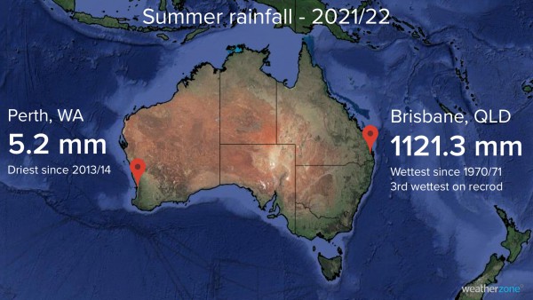
The map below shows just how different summer was on opposite sides of the country, with Brisbane received about 215 times as much rain as Perth.

Perth’s 5.2 mm of rain was its driest summer in eight years and only 12 percent of the city’s summer average of 42.3 mm.
Brisbane’s 1121.3 mm was the city’s third highest summer total in records sating back to 1840, beaten only by 1181.2 mm in 1970/71 and 1451.1mm in 1892/93. This was well above Brisbane’s long-term summer average of 451.2 mm.
It was also Brisbane’s cloudiest summer in a decade and Perth’s sunniest summer in eight years, with the two cities averaging 7.6 hours and 12.2 hours of daily sunshine, respectively.
Looking ahead La Niña is likely to persist at least into the first half of autumn, which should continue to bring above average cloud and rainfall to many parts of Australia, including the east. However, there’s roughly an equal chance of above or below average rainfall for the west coast during Autumn.
Solar power is becoming increasingly important in the energy markets, however the variable nature of solar generation poses significant challenges for integration into the electricity industry.
Weatherzone, in partnership with Solcast, provides solar power forecasting and solar irradiance data, for both large-scale solar farms and small-scale PV systems, plus their grid or regional aggregates. We also offer seasonal rain and solar forecasts out to 6 months, for more information, please contact us at apac.sales@dtn.com.




