Heavy rain and damaging winds are spreading along the Kimberley coast as Ex-Tropical Cyclone Anika gets set to reintensify over the coming days.
Tropical Cyclone Anika formed over the Timor Sea on Friday night before drifting south and making landfall over the north Kimberley coast on Saturday night. Anika crossed the coast as a category two tropical cyclone to the east of Kalumburu.
Since making landfall, Anika has weakened below tropical cyclone strength and has been traversing the north Kimberley, causing strong winds and heavy rain to spread further west

Image: Enhanced visible/infrared satellite image showing Ex-Tropical Cyclone Anika over the Kimberley around lunchtime on Monday.
At 8am AWST on Monday, Ex-Tropical Cyclone Anika was located roughly 65 km to the east southeast of Kuri Bay and 400 km northeast of Broome.
At this stage, the system is expected to continue moving towards the southwest in the coming days, which should allow it to move back off the west Kimberley coast on Tuesday and start to reintensify.
Once over open water, the low should redevelop into a tropical cyclone somewhere to the north of Derby or Broome. Forecast models suggest that the strengthening system could then turn south in the middle of the week and possibly make a second landfall.

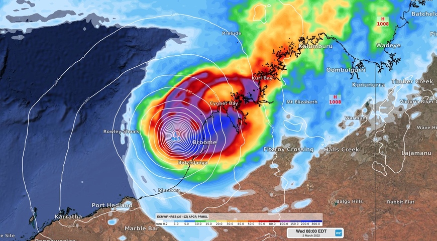
Image: Forecast 24-hour accumulated rain and mean sea level pressure on Monday morning, according to the ECMWF-HRES model.
Based on current model guidance, this second coastal crossing will most likely occur as a category three tropical cyclone, somewhere over the east Pilbara or west Kimberley coast on Wednesday or Thursday.
Tropical cyclone watches and warnings, and a flood watch, have been issued for parts of northern WA and these will be updated in the coming days as the system develops

Image: Forecast accumulated rain between Monday and Thursday, according to the ECMWF-HRES model.
Communities and industries located between the Mitchell Plateau and Port Hedland should closely monitor the latest tropical cyclone advisories in the coming days for the most up-to-date information.
For more information on Weatherzone’s tropical cyclone forecasting, please contact us at apac.sales@dtn.com.


