
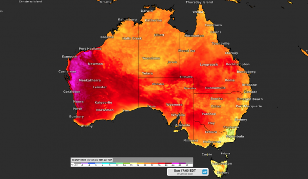
Perth could soon add another one or two days to its already record-breaking tally of 11 40ºC days so far this summer.
Two intense heatwaves in late-December and mid-January have seen Perth endure unprecedented heat this season.
At the start of this week, the city had already registered 11 days at or above 40º so far this season. This beat the previous record of seven days from the summer of 2015/16.

The most recent heatwave, which occurred between January 18 and January 23, produced Perth’s first string of six consecutive 40ºC days on record.
But while this has already been a summer without precedent in Perth, it’s not over yet.
The city is forecast to nudge 40ºC again this weekend and possibly early next week. Maximum temperatures could reach about 39 to 40ºC between Saturday and Monday and at this stage, one or two of these days has the potential to reach 40ºC.
There is some uncertainty regarding the timing of a southerly change with a weak cold front early next week. This means Monday’s forecast is prone to change in the coming days as the timing of this front becomes clearer.

Image: Forecast surface air temperature on Sunday, showing hot air hugging Australia west coast.
The impending heat has the potential to add another two 40ºC days to the summer tally, which would extend this season’s record to 13 in total.
There will be some slight relief from the heat in the middle of next week, although maximum temperatures should be back up to the high-thirties by around next Friday.
This month’s record-breaking heat in Perth has been caused by several factors:
- A lack of monsoon cloud cover in Australia’s western tropics has allowed extremely hot air to build up over the Pilbara and Kimberley regions of WA.
- Regular bursts of offshore winds along the state’s west coast, facilitated by stubborn West Coast Troughs, have caused the mercury to soar in Perth in recent weeks.
- Climate change has also made extreme heat more likely, with maximum temperatures in southwestern Australia increasing by 1.4ºC since 1910.
Weatherzone provides the energy sector with temperature, risk of extreme heat and long term temperature forecasts, for more information, please contact us at apac.sales@dtn.com.




