Prosper in a dynamic world
Search

Dangerous heat on the horizon for southeast QLD


A mass of extremely hot and humid air will cause oppressive conditions in southeast Queensland in the middle of next week. 

A pool of hot air originating over western Queensland will be pushed over the state’s southeast in the middle of next week. 

While bursts of hot weather are common in southeast Queensland during summer, next week’s heat will be accompanied by abundant atmospheric moisture and high relative humidity. 

The result of this hot and muggy air will be two days and nights of oppressive warmth, which will make it more difficult than usual for the body to cool down from sweating. 

MicrosoftTeams-image (205)

  MicrosoftTeams-image (206)

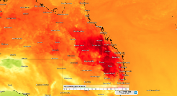
Images: Forecast surface air temperature during the afternoon on Tuesday (top) and Wednesday (bottom), according to the ECMWF model. 

Maximum temperatures should reach about 33 to 35ºC on Tuesday and Wednesday, respectively. However, the high humidity will make it feel about 3 to 5ºC warmer than this. 

Afternoon sea breezes and potential shower activity will provide some relief from the heat, however the high humidity will continue to make it continue to feel muggy well into the night. 

While minimum temperatures should drop to about 22 to 23ºC on Monday and Tuesday nights, models suggest that temperatures will still be feeling like the mid-to-high twenties on both nights. 

The heat and humidity will be flushed out of southeast Queensland on Thursday, February 3rd by a welcome southerly change. Maximum temperatures are expected to stay below 30ºC from Thursday until at least the start of the following week. For more information on Weatherzone’s energy forecasting, please contact us at apac.sales@dtn.com.

Latest news

Satisfy your weather obsession with these news headlines from around the nation, and the world.

High tropical cyclone risk near northern Australia this week

A tropical low currently developing over the Timor Sea has a high chance of becoming a tropical cyclone later this week, with a possibility of landfall somewhere in the Northern Territory or Western Australia. Key industries could be impacted including Ports, Mining, Transport, and Agriculture. The satellite images below show cloud circulating around the developing […]

Madden-Julian Oscillation increasing tropical cyclone potential for northern Australia industries

Sea surface temperatures exceeding 31°C off the coast of northern Australia and an active phase of the Madden-Julian Oscillation (MJO) are increasing the likelihood of early-season tropical cyclone activity, with hints of the season’s first tropical cyclone coming as early as next week. Tropical cyclones require sea surface temperature of 26.5°C or warmer to develop, […]

Tropical cyclone season begins with warm oceans surrounding northern Australia

The 2025-26 tropical cyclone season has begun with abnormally warm oceans surrounding northern Australia, signalling an increased risk for severe tropical cyclones in the coming months. The Australian tropical cyclone season runs from November 1 to April 30. During this six-month period, there are usually about 9 to 10 tropical cyclones in the Australian region, […]

7.8 million lightning pulses detected by DTN’s Total Lightning Network over Australia in one week

A barrage of thunderstorms battered large areas of eastern and northern Australia over the past week, producing close to 8 million lightning pulses across the country and more than 4 million over Queensland alone. DTN’s Total Lightning Network (TLN) detected around 7.79 million lightning pulses above Australia last week. This lightning was observed over every […]