There are signs that rain and thunderstorms will increase over northern Australia during the next week, raising the likelihood of tropical cyclone development in the region.
A monsoon trough is expected to move over northern Australia during the next few days, causing rain and storm activity to increase in parts of QLD, the NT and WA.
This increase in convective activity could cause a low-pressure system to develop within the trough, most likely over the Timor Sea later this week.
Some models suggest that this low could move south towards the Kimberley coast on the weekend and early next week.
If this low lingers over the ocean, there is a chance of it developing into a tropical cyclone off the Kimberley coast early next week. However, if it moves too close to or over land, it is unlikely to develop into a cyclone.
At this stage the greatest risk of tropical cyclone development will be between Monday and Wednesday and near the west Kimberley coast.

Image: Forecast accumulated 24-hour rain and mean sea level pressure (MSLP) at 11pm AEDT on Tuesday, January 25, according to the Access-G model.
Regardless of whether we see a tropical cyclone, the southward-moving monsoon trough will still cause an increase in rain and thunderstorms over northern Australia in the coming week.
This new injection of tropical moisture will also spread further south next week and combine with another moisture-laden airmass left behind by Ex-Tropical Cyclone Tiffany.
As a result of these two sodden tropical air masses, a large area of central, eastern and southeastern Australia is likely to see substantial rain during the next 7 to 10 days.

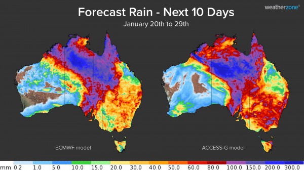
Image: Forecast accumulated 10 day rainfall from January 20th to 29th comparing ECMWF and ACCESS-G models.
Accumulated rainfall totals over the next ten days are forecast to be around 30-60mm across a broad area including the NT, northern WA, QLD, SA, NSW, ACT, VIC and TAS. Some areas may see isolated falls of 100-250mm over the next ten days and some places could pick up more than 300mm.
This widespread rain has the potential to cause flooding in several states and territories. It will also be falling in areas of the country that are usually dry in summer, with some inland areas of SA in line to receive more than two times their average summer rainfall in the space of one week.
Flood advisories, severe weather warnings and tropical cyclone warnings will be issued, when necessary, over the next 10 days. For more information on Weatherzone’s tropical cyclone and rainfall forecasting, please contact us at apac.sales@dtn.com.


