Prosper in a dynamic world
Search

Another hot week in Perth


Perth could get close to 40ºC on each of the next five days as a Severe Heatwave grips Australia’s west coast.

A near-stationary high pressure ridge over WA and a persistent West Coast Trough will direct a stream of hot easterly winds over Australia’s west coast during the remainder of this week.

This synoptic setup is common in summer, and it’s known to produce lengthy heatwaves in Perth as hot offshore winds delay the Fremantle Doctor.

Maximum temperatures are likely to reach 38 to 40ºC in Perth every day between Tuesday and Saturday, and could hit around 34 to 37ºC each day from this Sunday until Wednesday next week.

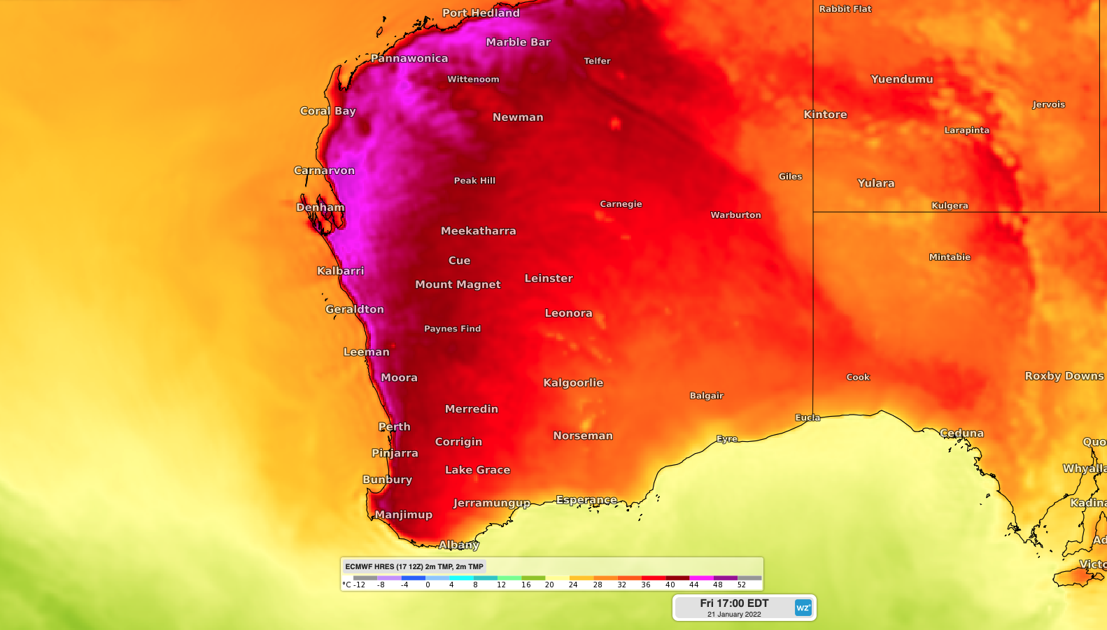
Image: Forecast surface air temperature along the west coast on Friday afternoon, according to the ECMWF model.

This week-long run of hot days continues a sweaty start to summer in the WA capital city.

Perth registered five days at or above 40ºC in December, which hasn’t happened since 1997. Four of these 40ºC days were consecutive, which is a feat that’s only happened on two other occasions in the records dating back to 1897.

This week’s heat will cause a Severe to locally Extreme Heatwave in western coastal districts of WA, from the Southwest Capes up to Exmouth.

This persistent heat will contribute to Very High to Extreme fire danger ratings over the coming week. For more information on Weatherzone’s temperature, extreme temperature and fire forecasting, please contact us at apac.sales@dtn.com.

Latest news

Satisfy your weather obsession with these news headlines from around the nation, and the world.

Perth sets rainfall streak not seen in 18 years as water storage levels fall

For four months in a row, Perth has exceeded its average monthly rainfall – the first time this has happened in the traditionally wet winter and spring period since 2007. Perth reached its September average of 79.3mm during light showers on Tuesday and Wednesday. Another 13.2mm of rain then fell in the 24 hours to […]

DTN remote sensing captures rain and thunderstorms lashing Solomon Islands

Aviation, mining and shipping industries in the Solomon Islands and other South Pacific nations are often unable to use traditional radar to warn of incoming storms that disrupt operations and put workers in harm’s way. DTN APAC offers a suite of remote sensing weather solutions that give businesses and industries in remote areas around the […]

Negative Indian Ocean Dipole officially underway – here’s what it means for Australian businesses and industries

A negative Indian Ocean Dipole (IOD) event is now underway, increasing the likelihood of above average rain over large parts of Australia in the coming months. What is the Indian Ocean Dipole (IOD)? The IOD is an index used to monitor sea surface temperatures across the tropical Indian Ocean. It’s an important index for the […]

La Niña more likely this year after BoM switches to new index – what does this mean for Australian businesses?

The likelihood of La Niña occurring in 2025 has increased due to a change in the way the Bureau of Meteorology calculates sea surface temperature anomalies in the tropical Pacific Ocean. What is La Niña? La Niña refers to a distinct pattern of sea surface temperatures across the tropical Pacific Ocean. When La Niña is […]