There are early signs that tropical cyclone activity could pick up in the Australian region between Christmas and New Year’s Eve.
We have already seen three tropical cyclones in the Australian region since the start of the cyclone season on November 1.
Tropical Cyclone Paddy developed near Christmas Island in mid-November, which is several weeks earlier than usual for Australia’s first cyclone of the season.
Paddy was followed by Tropical Cyclone Teratai in the same region at the start of December.
More recently, Tropical Cyclone Ruby formed over the eastern Coral Sea in mid-December, impacting New Caledonia but not having any direct effect on Australia.

Image: Visible satellite image of Tropical Cyclone Ruby to the north of New Caledonia on Monday, December 13, 2021.
A number of factors contributed to the formation of these early-season tropical cyclones in the last 4 to 5 weeks:
- Abnormally warm sea surface temperatures to the north of Australia
- La Niña
- Active phase of the Madden Julian Oscillation (MJO) in the Australian region
At least some of these cyclone-inducing features are still in place to the north of Australia as we head towards the final week of 2021.
Current Conditions
Sea surface temperatures near northern Australia are much warmer than normal at the moment, which is partially driven by La Nina. These warm ocean temperatures are favourable for tropical cyclone development in the Australian region.

Image: Sea surface temperature anomalies on December 18, 2021, showing an abundance of unusually warm water to the north of Australia. Source: NOAA
The Madden Julian Oscillation (MJO) – a pulse of cloud and rainfall that moves eastwards around the equator every 30-60 days – is currently in the Western Pacific and is expected to remain in this region for the next week or so.
When the MJO is near Australia, it can increase the risk of cyclone development in the region. While when it is away from the region, it reduces the risk of cyclones near Australia.
When the MJO is in the Western Pacific, the eastern Top End and far Northern QLD have a higher chance of above average rainfall.

Image: The eastward movement of the Madden-Julian Oscillation can cause an increase in cloud, rain and wind as it moves through the Australian region.
What’s ahead?
The MJO may still help increase rainfall in parts of northern Australia during the last two weeks of 2021 as it lingers in the Western Pacific region. More locally, above average sea surface temperature will also continue to promote convection and tropical cyclone development in the coming weeks.

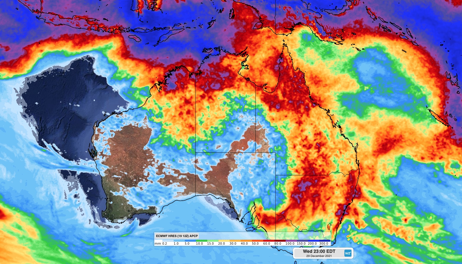
Image: Forecast accumulated rain during the 10 days ending on December 29, 2021, according to the ECMWF-HRES model. This model shows a notable increase in rainfall over parts of northern Australia during the next 10 days.
A number of computer models are predicting an increase in tropical cyclone potential near northern Australia between Christmas and New Year’s Eve.
It’s worth noting that there is quite a lot of model uncertainty regarding cyclone formation during this period. However, there is some alignment between models regarding the general areas and times to watch.
At this stage, the areas that have the greatest risk of see a tropical cyclone before the end of the year are the Top End, Gulf of Carpentaria and the northwest of WA.
The likelihood of tropical cyclone development increases from around December 27, however cyclone formation can’t be ruled out around Christmas Day at this stage.
More reliable model guidance will become available in the coming days and weeks. Our meteorologists will continue to monitor the situation closely and bring further updates as they become available. For more information on Weatherzone’s cyclone forecasting and consultancy, please contact us at apac.sales@dtn.com.


