While you’d struggle to find a small patch of blue sky across eastern Australia, summer has arrived early in Perth. Perth’s maximum temperatures are expected to top 34°C on Friday, 37°C on Saturday and 33°C on Sunday.
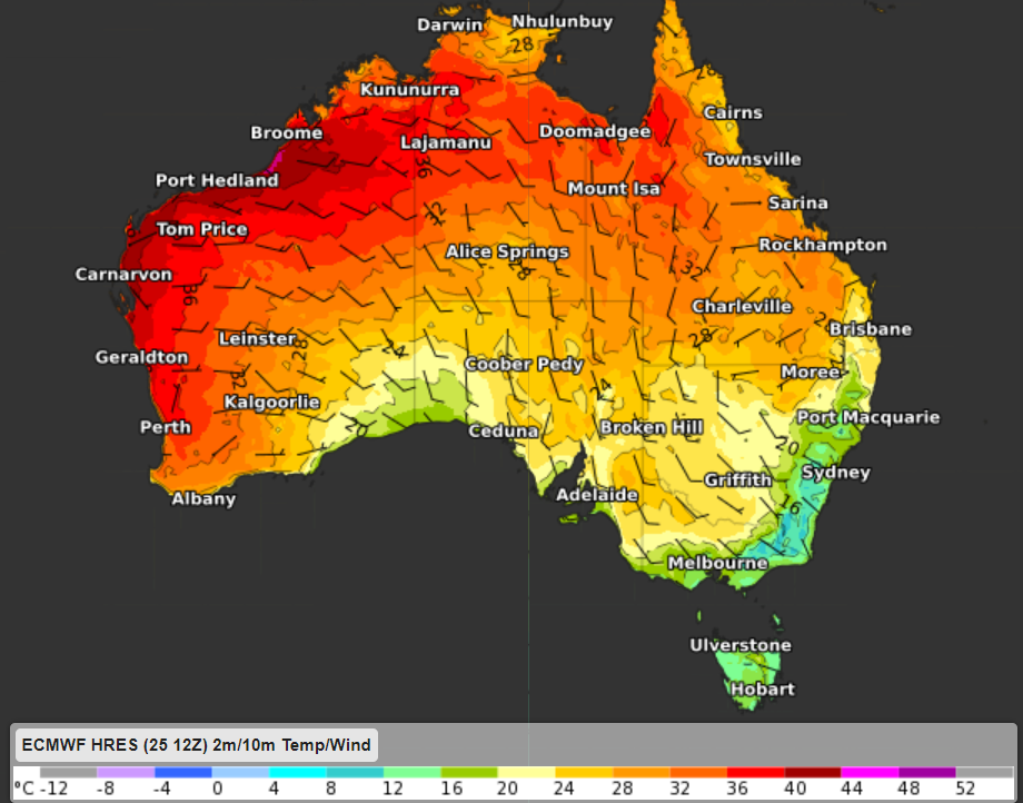
Saturday’s daytime temperature is expected to be 9-10°C above Novembers average, the hottest day in eight months (figure 1)
Figure 1: ECMWF 2m temperature and 10m wind at 2pm WST on Saturday, November 27.
When was the last time Perth was this hot and dry?
- The last time Perth reached or exceeded the mid-thirties was way back on March 29 this year, when the mercury peaked at 39.0°C.
- The hottest since then was October 15, 2021, when the mercury reached 33.2°C.
- As is typical for this time of year, Perth has started to dry out during November, after a super wet October, in which the city tripled its monthly average of 40.9 mm with 122.8 mm, and indeed broke the October rainfall record.
- While 40.4 mm of rain fell on November 9, that was just one of three ground-wetting days this month, and no rain is on the cards for the next week.
So the big dry typical of a Perth summer is on its way, and while temperatures should dip back into the mid-to-high twenties early next week, the heat looks to peak this weekend.
Why is the west coast warm and dry, while the east experiences a mild and wet summer during La Nina years?
During La Nina years, high pressure over southern Australia is common, which for Perth means dry and hot easterly winds from the interior of Australia. These easterly winds promote warmer weather for Perth and the west coast (figure 1).
While easterly winds across the east coast of Australia are humid, cool and produce rain and cloud as they hit the Great Dividing Range.
Weatherzone’s model Opticast is an industry leader and can forecast maximum and minimum temperatures up to two weeks out, including confidence intervals and risk of extreme heat. For more information, please contact us at apac.sales@dtn.com.


