Prosper in a dynamic world
Search

Oracle captures the Papua New Guinea storm this week


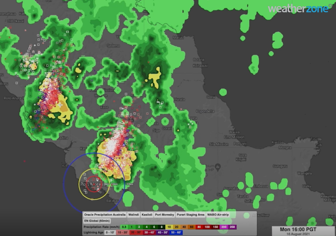
A thunderstorm rolled into Port Moresby, Papua New Guinea from the west on Monday, August 16, with little warning to locals about the Papua New Guinea storm due to sparse radar coverage (figure 1).

Oracle our new ‘radar’ system captured the storm, lightning, and heavy rainfall perfectly, well in advance and before the storm made its way through Port Moresby. 

Our clients in Port Moresby, with Oracle, were warned well in advance of the storm and rainfall, with the ability to track the storm. This enabled our clients to plan and prepare for the storm ahead of time, which is key for safety and productivity.  

Figure 1: Oracle radar capturing lightning and heavy rainfall between 1-4pm PGT on Monday, August 16, 2021.  

The Papua New Guinea storm (figure 1) illustrated the power of the Oracle system; however, it is worth noting this can be deployed anywhere in the world. 

 This storm clearly demonstrated the power of the Oracle system near Port Moresby. However, it is worth noting that Oracle can be deployed anywhere in the world, enabling users to see rain as it is happening wherever they are.  

In addition to tracking current rain, Oracle also provides live forecasts of rainfall rates, lightning, and cloud for up to three hours in advance, for anywhere in the world. 

It does this by feeding live satellite imagery, lightning data and nearby radar imagery into the forecast system. This innovative technology was built in collaboration with Solcast.  

Oracle is a more than adequate replacement for radar, but the genius of it is that it’s also a one-of-a-kind forecast system, delivering accurate forecasts out to four hours.  

Stay tuned for additional updates on Oracle’s new forecasting capabilities. For more information, please contact us at apac.sales@dtn.com 

Latest news

Satisfy your weather obsession with these news headlines from around the nation, and the world.

El Niño Is Here: What a Potential Record Event Means for Southeast Asia and Australia

  El Niño was officially declared in June 2026, raising the prospect of widespread impacts across Southeast Asia, from extreme heat and water shortages to higher energy demand and agricultural stress.   The World Meteorological Organization has warned countries to “prepare for it to be severe”, while several global forecast models suggest the event could rank among […]

How El Niño will shape Australian port operations in winter-spring 2026

Australian ports and marine pilots can expect a season of shifting wind and swell patterns through winter and spring 2026, as a developing El Niño brings the likelihood of drier conditions and more variable operating windows across the country’s coastline.  Will El Niño develop in 2026?  There are clear signs that an El Niño pattern is becoming […]

From Kimberley to northern NSW: Bushfire outlook flags risk for resources sector this winter

Bushfire risk doesn’t usually make headlines in June, but AFAC’s winter seasonal outlook is putting mining and resources operators on alert from the Kimberley to the NSW.  Australia’s official seasonal bushfire outlook for winter 2026 was released by AFAC on Thursday, May 28. The outlook predicts increased fire risk across the northern parts of the Great Sandy Desert and surrounds […]

The signal was there weeks earlier: forecasting one of the year’s biggest wind events

In mid-May 2026, DTN APAC meteorologists flagged a strengthening Southern Ocean pattern in model guidance, signalling an extended run of record-challenging wind conditions across the NEM.  Nearly three weeks later, NEM wind generation climbed from around 1.5GW to more than 9GW, supplying roughly one-third of the grid and coming within 1GW of the all-time generation record.  The event highlighted […]