Prosper in a dynamic world
Search

Tropical cyclone Seroja may swing towards WA later this week


Tropical cyclone Seroja is currently located well to the north-northwest of Broome and unlikely to impact Western Australia during the next few days (right track figure 1). However, the cyclone is forecast to swing south later this week, tracking parallel to the coast near Exmouth and Carnarvon (figure 1).  

At the same time, a tropical low has also formed near Christmas Island and its interaction with Seroja will play a huge role in Seroja’s movement (left track in figure 1).

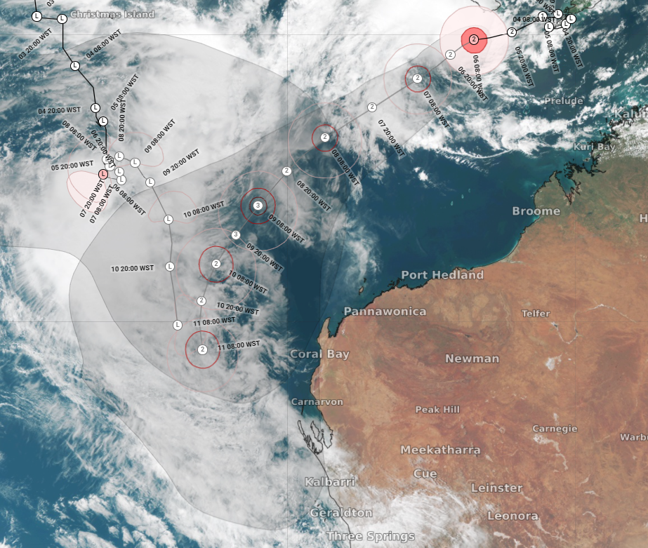
Figure 1: BOM tropical cyclone Seroja and low forecast issued on the 6th of April at 9am WST and satellite imagery. 

There is a huge amount of uncertainty in the track of the cyclone and whether it will impact the Western Australia. Some models show the cyclone approaching the Western Australian coastline later this week into the next, while others keep the cyclone offshore. 

With a cyclone and a low in the mixweekly rainfall totals of 40-70mm are forecast for western WA, with isolated falls above 90mm (figure 2). The rainfall totals are highly dependent on the movement of the cyclone. Severe storms may also bring very heavy rainfall, particularly for areas to the north and east of the tropical low/cyclone. 


If the cyclone was to come near or cross the coast, heavy rainfall and damaging or destructive winds are all possible, beginning on the coastal strip first before extending inland. 

Given the uncertainty in the track of the cyclone, please ensure you keep up to date with our forecasts and warnings. For more information on our services, please contact us at business@weatherzone.com.au.

Latest news

Satisfy your weather obsession with these news headlines from around the nation, and the world.

High tropical cyclone risk near northern Australia this week

A tropical low currently developing over the Timor Sea has a high chance of becoming a tropical cyclone later this week, with a possibility of landfall somewhere in the Northern Territory or Western Australia. Key industries could be impacted including Ports, Mining, Transport, and Agriculture. The satellite images below show cloud circulating around the developing […]

Madden-Julian Oscillation increasing tropical cyclone potential for northern Australia industries

Sea surface temperatures exceeding 31°C off the coast of northern Australia and an active phase of the Madden-Julian Oscillation (MJO) are increasing the likelihood of early-season tropical cyclone activity, with hints of the season’s first tropical cyclone coming as early as next week. Tropical cyclones require sea surface temperature of 26.5°C or warmer to develop, […]

Tropical cyclone season begins with warm oceans surrounding northern Australia

The 2025-26 tropical cyclone season has begun with abnormally warm oceans surrounding northern Australia, signalling an increased risk for severe tropical cyclones in the coming months. The Australian tropical cyclone season runs from November 1 to April 30. During this six-month period, there are usually about 9 to 10 tropical cyclones in the Australian region, […]

7.8 million lightning pulses detected by DTN’s Total Lightning Network over Australia in one week

A barrage of thunderstorms battered large areas of eastern and northern Australia over the past week, producing close to 8 million lightning pulses across the country and more than 4 million over Queensland alone. DTN’s Total Lightning Network (TLN) detected around 7.79 million lightning pulses above Australia last week. This lightning was observed over every […]